PAGASA provides critical updates on two tropical storms affecting the Philippine Area of Responsibility (PAR): Tropical Storm Nika (internationally known as “Toraji”) and Tropical Storm OFEL (known internationally as “Usagi”). Below is an overview of the current status, expected track, and potential impacts of these storms.

Tropical Storm Nika (TORAJI)
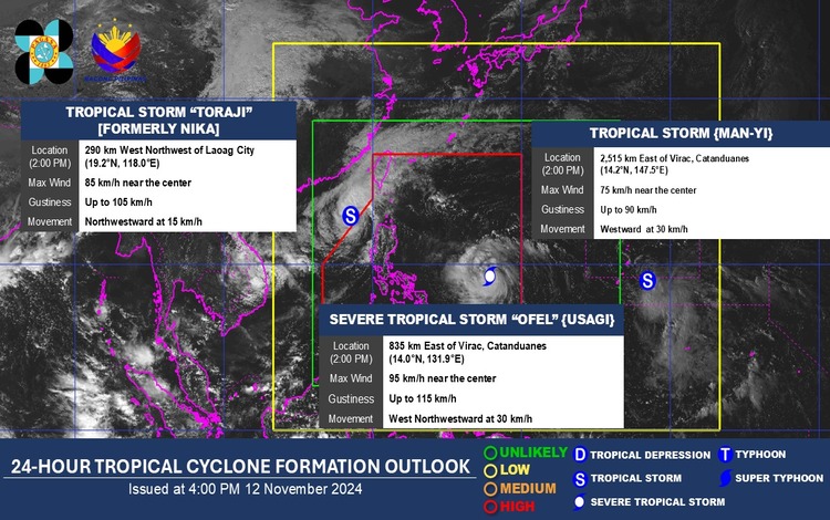
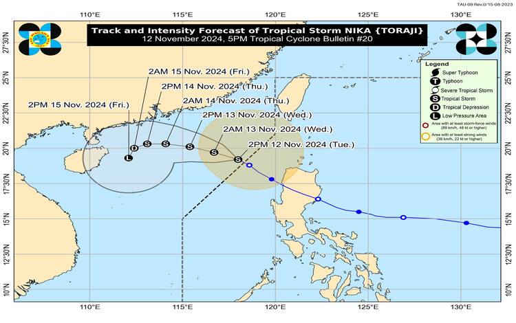
After a period of intense activity, Tropical Storm Nika weakened and exited the PAR. As of 4:00 PM, its center was estimated to be 365 kilometers west of Calayan, Cagayan, positioned outside PAR coordinates at 19.4°N, 118.0°E. Nika now maintains maximum sustained winds of 85 km/h, gusts reaching up to 105 km/h, and a central pressure of 992 hPa. The storm is currently moving northwest at 15 km/h.
While Nika no longer poses a direct threat to the Philippine mainland, it continues to impact certain maritime areas. PAGASA has issued a final Gale Warning, advising caution to mariners and small seacrafts, as strong to gale-force winds extend outwards up to 420 kilometers from its center.

Wind and Rainfall Hazards
No Tropical Cyclone Wind Signals (TCWS) are hoisted, as Nika’s impact on land has lessened. However, its peripheral effects will still bring strong gale-force gusts across the Luzon Strait, particularly affecting the Batanes and Babuyan Islands. Residents in these areas should expect brisk coastal winds and occasional gusts throughout the evening and into the following day.
On rainfall, PAGASA reports that Nika will not bring significant precipitation across the Philippines over the next three days, reducing concerns for heavy rain-related flooding or landslides.
Coastal Inundation and Sea Condition
The threat of storm surge from Nika has diminished significantly, and PAGASA has issued a final Storm Surge Warning. Although coastal communities are out of immediate danger, sea conditions remain turbulent. Waters around the western seaboard of Batanes and Babuyan Islands, as well as the seaboard of Ilocos Norte, are expected to be rough, with waves reaching heights of up to 3.0 meters. Mariners, especially those on smaller vessels or with limited experience, are strongly advised against venturing out.
Other areas with moderate sea conditions include the remaining seaboards of the Ilocos Region, Cagayan Valley, and several eastern and northern seaboards across Luzon and the Visayas. Mariners are urged to take precautions and remain vigilant of the changing sea conditions.
Track and Future Outlook
Tropical Storm Nika is forecasted to continue moving west-northwestward across the West Philippine Sea and is anticipated to turn southwestward by Thursday. Due to a combination of unfavorable environmental factors, Nika is expected to gradually weaken into a tropical depression on Thursday evening or early Friday morning. The storm may further deteriorate, potentially degenerating into a remnant low-pressure area by Friday afternoon or evening, effectively ending its lifecycle.
Tropical Storm OFEL (USAGI)
Meanwhile, another weather disturbance, Tropical Storm OFEL (internationally known as “Usagi”), has entered closer proximity to the Philippines and is positioned approximately 800 kilometers east of Southeastern Luzon at 14.0°N, 131.6°E. OFEL currently exhibits maximum sustained winds of 95 km/h, gusting up to 115 km/h, and is moving west-northwestward at a rapid pace of 30 km/h.
PAGASA’s forecast indicates that OFEL’s movement may bring it closer to the eastern regions of Luzon, prompting residents to prepare for possible shifts in weather conditions over the next 24-48 hours.
Forecast Weather Conditions
The Visayas, Palawan (including the Kalayaan Islands), and Occidental Mindoro will experience generally fair weather with partly cloudy to cloudy skies. However, isolated rain showers or thunderstorms are likely, driven by localized weather disturbances. These thunderstorms, while generally brief, could bring sudden downpours and potential localized flooding in low-lying areas.
Winds across these regions are forecasted to be light to moderate from the northwest to southwest, with sea conditions ranging from slight to moderate. Despite the relative calm, fishermen and operators of small boats should remain cautious, particularly in areas near the approach of OFEL.
Precautionary Measures and Monitoring
PAGASA advises that while Tropical Storm Nika has exited PAR, communities within the storm’s peripheral influence, particularly in northern Luzon, should remain vigilant to possible wind gusts and rough seas. Mariners and fishers should heed gale warnings and exercise caution. Additionally, as OFEL moves closer to the Philippines, residents in eastern Luzon should prepare for potential weather disturbances, even though OFEL’s path remains under observation.
Key Advisory Points
- Tropical Storm Nika: Now located outside PAR, weakening and moving westward, with its effects limited to gusty winds and rough seas over parts of northern Luzon.
- Tropical Storm OFEL: Positioned 800 km east of Southeastern Luzon, moving towards the Philippines. While it currently poses no direct threat, OFEL’s continued approach warrants careful monitoring.
PAGASA will continue to provide updates on both systems, particularly as OFEL approaches Luzon. The public is urged to follow official advisories and be prepared for any changes in the weather that may arise over the coming days.
