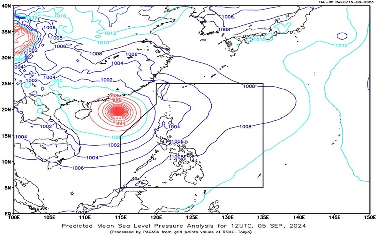
The Philippine Atmospheric, Geophysical, and Astronomical Services Administration (PAGASA) reports that Super Typhoon Yagi, formerly known as Enteng, is located 595 kilometers west-northwest of Laoag City, Ilocos Norte. Yagi, with maximum sustained winds of 195 km/h and gusts up to 240 km/h, is moving westward slowly. Although it is currently outside the Philippine Area of Responsibility (PAR), its influence is being felt in parts of the country.
Weather Conditions by Region
- Batanes and Babuyan Islands: Cloudy skies are expected with scattered rains and thunderstorms. This weather is attributed to the trough of Super Typhoon Yagi. Residents should be cautious of potential flash floods or landslides due to moderate to heavy rains.
- Pangasinan, Zambales, and Bataan: These areas will experience monsoon rains driven by the Southwest Monsoon. Heavy to intense rainfall may lead to possible flooding or landslides.
- Metro Manila, Cavite, Batangas, Rizal, Laguna, Oriental Mindoro, Occidental Mindoro, Cordillera Administrative Region, Ilocos Region, and Central Luzon: Expect occasional rains caused by the Southwest Monsoon. Residents should remain vigilant for flash floods or landslides due to moderate to heavy rains.
- Palawan, Quezon, Marinduque, Romblon, and the rest of Cagayan Valley: Cloudy skies with scattered rains and thunderstorms are forecasted. The Southwest Monsoon is the primary weather driver here, with a risk of flash floods or landslides from moderate to heavy rains.
- The Rest of the Country: Expect partly cloudy to cloudy skies with isolated rain showers or thunderstorms due to localized thunderstorm activity. Severe thunderstorms could bring flash floods or landslides.
Wind and Coastal Water Conditions
- Western Section of Luzon: Strong winds from the southwest to south are expected, with coastal waters becoming rough, ranging from 2.8 to 4.5 meters.
- Rest of Luzon: Moderate to strong winds from the southwest to southeast will be experienced, leading to moderate to rough coastal waters, measuring between 2.1 to 4.0 meters.
- Visayas and Mindanao: Winds will be light to moderate from the south to southwest, with coastal waters ranging from slight to moderate, at 0.6 to 2.5 meters.
Residents across the affected areas are advised to stay updated with PAGASA’s latest forecasts and warnings. Necessary precautions should be taken to mitigate the risks of flooding and landslides. Further updates will be provided as needed.