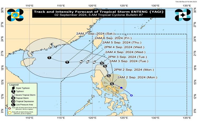
Tropical Storm Enteng has slightly intensified while decelerating over the coastal waters of Vinzons, Camarines Norte. The Philippine Atmospheric, Geophysical, and Astronomical Services Administration (PAGASA) has reported that the center of Enteng was estimated at 14.7°N, 123.0°E, with maximum sustained winds of 75 km/h near the center, gustiness of up to 90 km/h, and a central pressure of 998 hPa.
Present Movement and Wind Signals
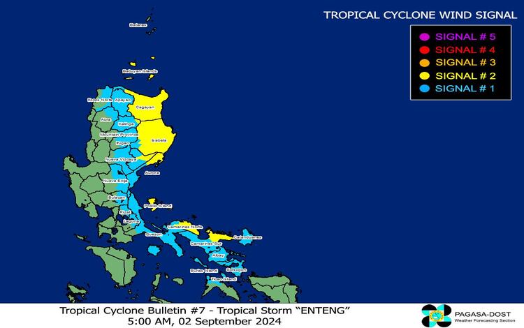
Enteng is currently moving west-northwestward at a speed of 10 km/h. Strong to gale-force winds extend outwards up to 250 km from the center of the storm. Given the intensity and movement of Enteng, PAGASA has issued Tropical Cyclone Wind Signals (TCWS) in several areas across Luzon.
- TCWS No. 2: Gale-force winds are expected in the northeastern portion of Camarines Norte, northeastern Camarines Sur, eastern Cagayan, eastern Isabela, Polillo Islands, eastern Quirino, and eastern Kalinga. Residents in these areas can expect winds of 62 to 88 km/h within the next 24 hours, posing a minor to moderate threat to life and property.
- TCWS No. 1: Strong winds are expected in the southern portion of Batanes, eastern Ilocos Norte, eastern Abra, Apayao, the rest of Kalinga, eastern Mountain Province, eastern Ifugao, the rest of Cagayan, the rest of Isabela, the rest of Quirino, eastern Nueva Vizcaya, the rest of Aurora, eastern Nueva Ecija, eastern Bulacan, eastern Rizal, eastern Laguna, northern and southern Quezon, Marinduque, the rest of Camarines Norte, the rest of Camarines Sur, Albay, Sorsogon, Catanduanes, and northern Masbate including Ticao and Burias Islands. Winds in these areas will range from 39 to 61 km/h, presenting a minimal to minor threat to life and property.
Heavy Rainfall and Flooding Risks
PAGASA has issued a heavy rainfall outlook with significant rainfall expected in various regions. Today, accumulated rainfall is forecasted as follows:
- >200 mm: Camarines Norte, Camarines Sur, Albay, Polillo Island, and the southern portion of mainland Quezon.
- 100-200 mm: Aurora, the rest of Quezon, Catanduanes, Masbate, and Sorsogon.
- 50-100 mm: Isabela, Quirino, Bulacan, Metro Manila, the rest of CALABARZON, Marinduque, and Romblon.
Tomorrow, September 3, heavy rainfall of 100-200 mm is expected in Isabela, Cagayan, Abra, Apayao, and Ilocos Norte, while 50-100 mm of rainfall is forecasted in Aurora, the rest of Ilocos Region, the rest of Cordillera Administrative Region, and mainland Cagayan Valley.
On Wednesday, September 4, 100-200 mm of rainfall is expected in Babuyan Islands, Apayao, Abra, Ilocos Norte, and Ilocos Sur, with 50-100 mm forecasted in Batanes, mainland Cagayan, and the rest of the Cordillera Administrative Region and Ilocos Region. Flooding and rain-induced landslides are anticipated, particularly in areas highly susceptible to these hazards.
Coastal Waters and Gale Warnings
The enhanced Southwest Monsoon, combined with the effects of Tropical Storm Enteng, will bring hazardous conditions over the coastal waters of the Philippines. Gale warnings are in effect over the eastern seaboard of Luzon and the southern seaboard of Southern Luzon. Sea travel is risky, especially for small seacrafts and motorbancas. Mariners are advised to avoid navigating these areas due to moderate to rough seas, with waves reaching 1.5 to 3.5 meters.
Track and Intensity Outlook
Tropical Storm Enteng is expected to continue its northwestward movement over the next 24 hours, possibly making landfall over Isabela or Cagayan by this afternoon or tonight. There is also a possibility of landfall over the northern portion of Aurora. As Enteng progresses, it may intensify into a severe tropical storm by Wednesday and could potentially reach typhoon strength by Thursday or Friday.
PAGASA will continue to monitor the situation and provide updates as necessary. Residents in affected areas are advised to stay vigilant, monitor weather reports, and heed the warnings of local authorities.