The Philippine Atmospheric, Geophysical, and Astronomical Services Administration (PAGASA) released its latest weather advisory on Tropical Depression “ADA” on January 14, 2026, warning of worsening weather conditions across large portions of the Visayas and Mindanao as the system continues to maintain its strength while slowing over the Philippine Sea.
As of 4:00 PM, the center of Tropical Depression Ada was estimated at 545 kilometers east of Hinatuan, Surigao del Sur, with maximum sustained winds of 45 km/h, gustiness reaching 55 km/h, and a central pressure of 1004 hPa. The weather disturbance is currently moving west-northwestward at 10 km/h, with strong winds extending as far as 500 kilometers from its center.
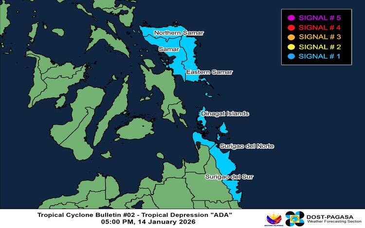
Wind Signals and Affected Areas
PAGASA has raised Tropical Cyclone Wind Signal No. 1 over several provinces in the Visayas and Mindanao, including Northern Samar, Samar, Eastern Samar, Dinagat Islands, Surigao del Norte, and Surigao del Sur. Under this signal, wind speeds of 39 to 61 km/h may occur within the next 36 hours, posing minimal to minor risks to life and property.
Authorities caution that wind impacts could be stronger along coastal and mountainous areas, particularly those directly exposed to the prevailing winds. PAGASA also noted that the highest wind signal that may be raised during Ada’s passage is Signal No. 2.
Monsoon Enhancement and Strong Gusts
Aside from Ada’s circulation, the Northeast Monsoon will intensify weather conditions across Northern Luzon, Central Luzon, CALABARZON, Bicol, Visayas, and parts of Mindanao over the coming days. Gusty to gale-force winds are expected in numerous coastal provinces from January 14 to 16, increasing risks of rough seas and dangerous travel conditions.
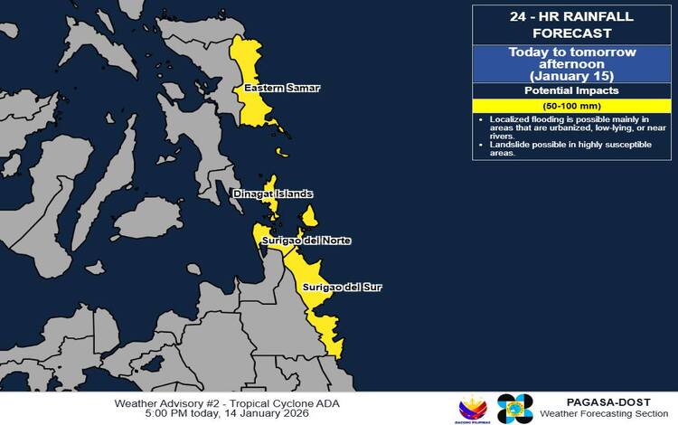
Heavy Rainfall and Flood Threat
PAGASA warned of widespread heavy rainfall as Ada approaches. From January 14 to 15, rainfall of 50 to 100 millimeters is forecast over Eastern Samar, Dinagat Islands, Surigao del Norte, and Surigao del Sur. Heavier rainfall of 100 to 200 millimeters is expected over Northern and Eastern Samar from January 15 to 16, with additional heavy rain impacting Bicol and Eastern Visayas through January 17.
Authorities emphasized that rainfall could be significantly higher in mountainous areas and that flooding and landslides may occur, especially in locations with saturated soil conditions.
Coastal and Marine Warnings
Seas will become rough to very rough, with wave heights reaching up to 4.0 meters along the eastern seaboards of Northern Samar, Eastern Samar, Catanduanes, Dinagat Islands, and Surigao del Sur. PAGASA strongly advises small fishing boats and motorbancas to remain in port.
Track and Outlook
Ada is forecast to strengthen into a tropical storm within 24 hours. It is expected to approach or make landfall over Eastern Visayas by January 16 or early January 17, before affecting Catanduanes and eventually turning northeastward over the Philippine Sea.
Disaster response agencies are urged to take immediate action to safeguard communities as weather conditions deteriorate.