September 26, 2025 – Severe Tropical Storm Opong (international name: Bualoi) is now traversing the Mindoro Strait, continuing to unleash heavy rains, strong winds, and dangerous sea conditions across large portions of Luzon and the Visayas.
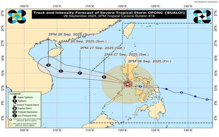
According to the Philippine Atmospheric, Geophysical and Astronomical Services Administration (PAGASA), the storm’s center was located at 4:00 p.m. Friday over the coastal waters of Santa Cruz, Occidental Mindoro (13.0°N, 120.3°E), based on data from the Busuanga Doppler Weather Radar. Opong carries maximum sustained winds of 110 kilometers per hour near the center, gustiness reaching 150 kph, and a central pressure of 985 hPa. It is moving west-northwestward at 35 kph.
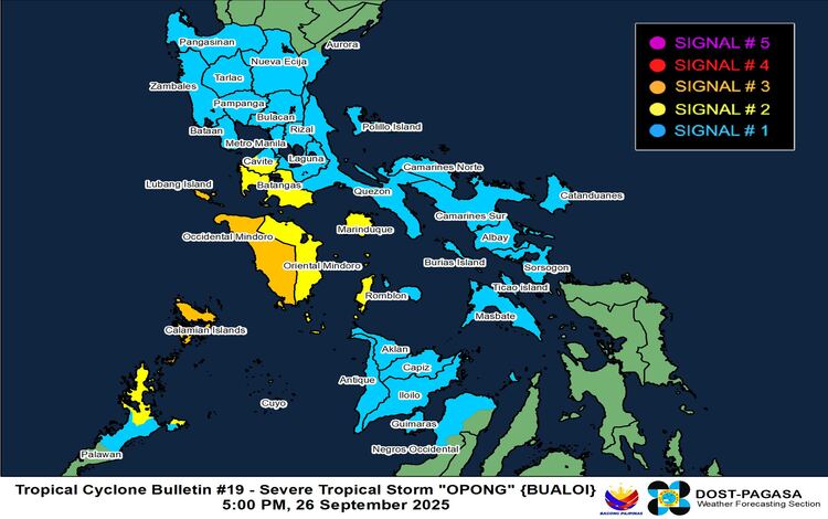
Wind Signals Raised
PAGASA raised Tropical Cyclone Wind Signal (TCWS) No. 3 over Occidental Mindoro and the Calamian Islands, warning of storm-force winds that pose a moderate to significant threat to life and property. Signal No. 2 is in effect over Cavite’s southern municipalities, Batangas, Marinduque, Oriental Mindoro, western Romblon, Cuyo Islands, and northern mainland Palawan. Meanwhile, Metro Manila, Pangasinan, Quezon, Bicol, and several areas in Western Visayas remain under Signal No. 1.
Authorities caution that winds may be stronger in coastal and upland areas directly exposed to the prevailing wind flow.
Rainfall and Flooding Threats
The storm, enhanced by the Southwest Monsoon, is forecast to dump heavy to intense rains over Occidental Mindoro, Palawan, including the Calamian Islands, and nearby provinces. Residents are advised to be aware of potential flash floods, landslides, and widespread flooding. PAGASA’s advisory emphasized that even areas outside the direct path of the cyclone may experience hazardous rainfall.
Hazards at Sea
A Gale Warning remains in effect for the seaboards of Central and Southern Luzon, the eastern coast of Northern Luzon, and the western waters of the Visayas. Sea conditions will remain very rough to high, with wave heights reaching up to nine meters along the seaboards of Occidental Mindoro, including Lubang Island. PAGASA warned that sea travel is risky for all vessels, and mariners are urged to remain in port until conditions improve.
Coastal communities in Bataan, Bulacan, Metro Manila, CALABARZON, Mindoro provinces, Marinduque, Romblon, Palawan, and parts of Western Visayas are also under a moderate to high risk of storm surge, with possible peak heights of one to three meters within the next 24 hours.
Projected Track
PAGASA forecasts Opong to continue its west-northwestward movement, emerging over the West Philippine Sea tonight. The system is expected to exit the Philippine Area of Responsibility (PAR) by Saturday afternoon, September 27. Forecasters also warned that Opong may re-intensify into a typhoon within the next 12 hours as it gains strength over open waters.
Government agencies and local disaster officials have been placed on heightened alert, urging residents in high-risk areas to remain vigilant and to follow evacuation orders when necessary.