September 25, 2025 – Severe Tropical Storm Opong (international name: Bualoi) maintained its strength Thursday afternoon while moving westward across the Philippine Sea, with state weather bureau PAGASA warning of multiple landfalls and widespread hazards across Luzon and the Visayas.
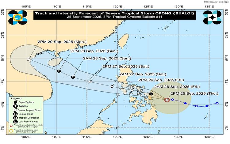
As of 4:00 p.m., the center of Opong was located 195 kilometers east northeast of Guiuan, Eastern Samar, or about 225 kilometers east of Borongan City. The storm is packing maximum sustained winds of 110 kilometers per hour (kph) near the center, gusts of up to 135 kph, and a central pressure of 980 hPa. It is currently moving westward at 15 kph, with strong to storm-force winds extending 460 kilometers from the center.
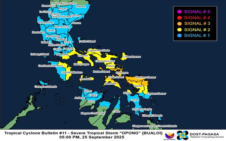
Tropical Cyclone Wind Signals Raised
PAGASA has raised Tropical Cyclone Wind Signal (TCWS) No. 3 over Sorsogon, northern Masbate, including Ticao and Burias Islands, Northern Samar, and parts of Eastern and Western Samar. These areas may experience storm-force winds within 18 hours, posing moderate to significant threats to life and property.
TCWS No. 2 is in effect over southern Quezon, Batangas, Camarines Norte, Camarines Sur, Albay, Catanduanes, Marinduque, Romblon, Oriental Mindoro, and parts of Eastern Visayas. Meanwhile, TCWS No. 1 covers Metro Manila, Central Luzon, Northern Mindanao, and several provinces in the Visayas.
Hazards Over Land and Sea
PAGASA warned that Opong could bring life-threatening storm surges exceeding 3.0 meters along coastal areas of Metro Manila, CALABARZON, Bicol, Eastern Visayas, and parts of MIMAROPA within the next 36 hours. Gale warnings are also in effect, with seas reaching up to 11 meters in height off Catanduanes and the eastern seaboards of Albay, Sorsogon, and Samar. All sea travel is considered risky, particularly for small vessels.
Heavy rainfall from Opong and the enhanced southwest monsoon is expected across Luzon, Visayas, and parts of Mindanao. PAGASA has issued general flood advisories for nine regions, including Metro Manila, Central Luzon, Bicol, and Eastern Visayas.
Landfall and Forecast Track
The storm is forecast to make its first landfall over Northern Samar or northern Eastern Samar early Friday, September 26, before crossing toward the Bicol Region, where another landfall near Sorsogon is possible later in the morning. PAGASA said Opong may intensify into a typhoon before landfall, then weaken slightly as it traverses Southern Luzon and Northern MIMAROPA, emerging into the West Philippine Sea by Saturday, September 27.
Re-intensification into a typhoon remains highly likely once the system exits into open waters.
Communities across Luzon and the Visayas are urged to brace for flooding, storm surges, and destructive winds as Opong continues to threaten large portions of the country.