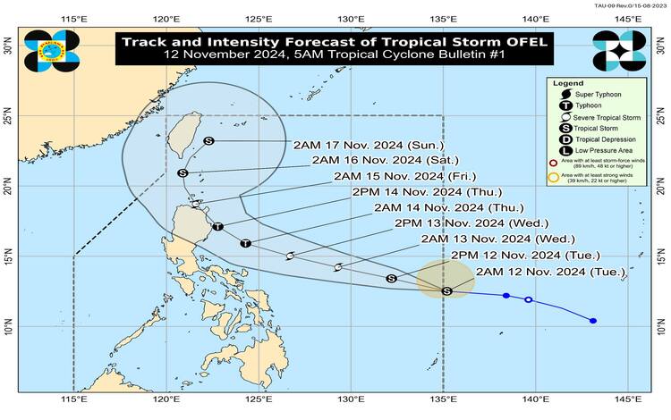
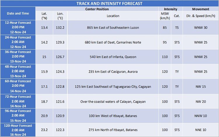
Tropical Storm Usagi, locally named “Ofel,” has officially entered the Philippine Area of Responsibility (PAR) as of early morning on November 12, 2024. The storm’s center was last recorded approximately 1,170 kilometers east of Southeastern Luzon at 4:00 AM, with coordinates at 13.0°N, and 134.8°E.

Intensity and Movement
Currently, Tropical Storm Ofel is exhibiting maximum sustained winds of 75 km/h near its center, with gustiness reaching up to 90 km/h. Its central pressure registers at 998 hPa. The storm is moving west-northwestward at a speed of 25 km/h, while strong to gale-force winds extend outwards up to 230 km from the center.
Tropical Cyclone Wind Signals (TCWS)
As of now, no Tropical Cyclone Wind Signal has been hoisted. However, it is anticipated that Signal No. 1 may be raised over portions of Cagayan Valley by late evening on November 12 or early morning on November 13. The highest TCWS that may be raised during Ofel’s course is Signal No. 4, as the storm potentially intensifies into a typhoon category.
Hazards Affecting Land Areas
- Heavy Rainfall
Currently, Tropical Storm Ofel is not directly affecting any part of the country. However, Pagasa has issued Weather Advisory No. 18 due to anticipated heavy rains associated with Ofel and the separate weather disturbance, Nika. - Severe Winds
As Ofel approaches, gale-force gusts are expected to impact various areas over the next few days:- November 13: Catanduanes
- November 14: Batanes, Quezon (including Polillo Islands), Camarines Norte, and northern Camarines Sur
- November 15: Isabela and northern Aurora
Residents in these areas, especially in coastal and elevated locations, are advised to brace for possible strong winds and secure lightweight structures as necessary.
Coastal Waters and Sea Condition Outlook
The following sea conditions are anticipated, raising risks for marine travel:
- Very rough seas (up to 4.5 meters): Seaboards of Ilocos Norte and northern Ilocos Sur. Pagasa warns that sea travel is highly risky for all types of vessels in these areas, and advises all mariners to remain in port or seek immediate shelter.
- Rough seas (up to 3.5 meters): Seaboards of Batanes and Cagayan, including the Babuyan Islands.
- Moderate seas (up to 2.5 meters): Northern Aurora and northern Zambales. Mariners of smaller vessels, such as motorbancas, are advised to exercise caution and avoid venturing out under these conditions.
Track and Intensity Outlook
Ofel is forecasted to maintain its west-northwestward path until the evening of November 14, before gradually shifting to a northwestward to northward direction. Based on the current trajectory, it is likely to make landfall over Northern or Central Luzon on November 14, either in the afternoon or evening.
The tropical cyclone is expected to strengthen steadily over the coming days and may intensify into a typhoon by Wednesday, potentially reaching land at peak intensity. Although the exact areas of landfall and specific impact zones remain uncertain, Pagasa emphasizes that hazards from wind, rainfall, and coastal conditions could extend beyond the immediate landfall point.

Precautions for Affected Regions
Residents in Northern Luzon are advised to prepare for potential heavy rains, strong winds, and possible storm surges, which may lead to flooding, landslides, and widespread disruptions. Eastern sections of Central and Southern Luzon may also experience impacts, particularly if the storm expands or takes a slightly more southern course.
Stay updated as Ofel progresses, given the possibility of shifts in the storm’s path and intensity. Adjustments in the projected track and affected areas may occur, especially toward the fourth and fifth days of the forecast period.
