The Philippine Atmospheric, Geophysical and Astronomical Services Administration (PAGASA) released its latest advisory on Tropical Storm “Paolo” (international name: Matmo) on October 2, 2025. Paolo has slightly intensified while moving west-northwestward over the Philippine Sea and is expected to affect multiple regions of Luzon with heavy rains, strong winds, and dangerous coastal conditions.
Location and Intensity
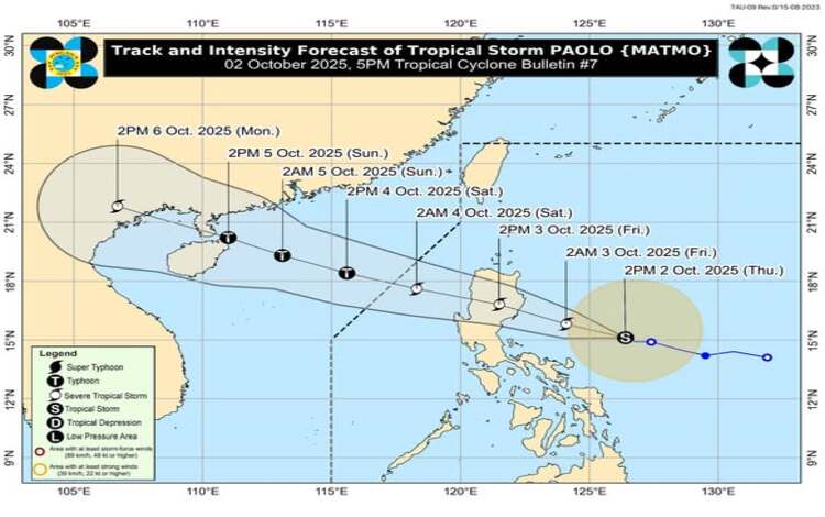
As of 4:00 PM, the center of Tropical Storm Paolo was estimated at 480 kilometers east of Infanta, Quezon, or 480 kilometers east of Baler, Aurora, based on available data, including Daet Doppler Radar. Paolo currently packs maximum sustained winds of 85 kilometers per hour near the center, gusts of up to 105 kilometers per hour, and a central pressure of 996 hPa. It is moving west-northwestward at 15 kilometers per hour, with gale-force winds extending up to 350 kilometers from the center.
Tropical Cyclone Wind Signals (TCWS)
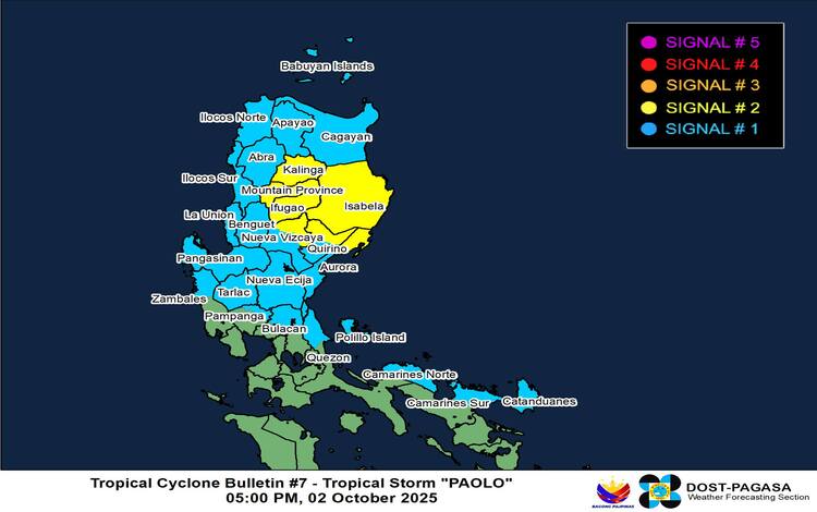
PAGASA has raised TCWS No. 2 in Isabela, parts of Quirino, Nueva Vizcaya, Kalinga, Mountain Province, Ifugao, and northern Aurora, warning of gale-force winds within 24 hours that pose a minor to moderate threat to life and property.
Meanwhile, TCWS No. 1 is hoisted in Cagayan, Apayao, Abra, Benguet, Ilocos provinces, La Union, Pangasinan, parts of Zambales, Tarlac, Nueva Ecija, the rest of Aurora, northern Bulacan, northern Pampanga, northern Quezon, including Polillo Islands, Camarines Norte, northern Camarines Sur, and Catanduanes. These areas may experience strong winds that could cause minimal to minor damage.
Authorities warned that Paolo could further intensify into a severe tropical storm and may even reach typhoon category before making landfall. The highest wind signal expected throughout its passage is TCWS No. 3, though in a worst-case scenario, TCWS No. 4 may be raised.
Rainfall, Flood, and Storm Surge Risks
Heavy rainfall is expected across Northern and Central Luzon, potentially leading to flash floods and landslides, especially in upland and low-lying areas. PAGASA has also issued General Flood Advisories for Regions I, II, III, CAR, CALABARZON, Bicol, MIMAROPA, Eastern Visayas, Western Visayas, and CARAGA.
There is a moderate to high risk of storm surge reaching 1.0 to 3.0 meters along coastal areas of Ilocos Norte, Cagayan, Isabela, Aurora, Quezon, Camarines Norte, Camarines Sur, and Catanduanes within 36 hours. Residents in these areas are advised to evacuate if necessary and heed local government advisories.
Sea Conditions and Gale Warnings
A gale warning is currently in effect over the eastern seaboards of Northern and Central Luzon. PAGASA reported seas of up to 6 meters along the Isabela coastline and up to 5 meters along northern Aurora and eastern Cagayan. Very rough seas of 3 to 4 meters are also expected across Ilocos Norte, Babuyan Islands, Ilocos Sur, northern Quezon, and Camarines Norte. Sea travel is considered risky for all vessels, with small boats and motorbancas strictly prohibited from sailing. Mariners are urged to seek shelter until conditions improve.
Track and Landfall Outlook
Based on PAGASA’s forecast, Paolo is projected to make landfall tomorrow morning, October 3, over southern Isabela or northern Aurora. The storm may slightly shift southward depending on the influence of a high-pressure system to its north. After crossing Northern Luzon, Paolo is expected to re-emerge over the West Philippine Sea by tomorrow afternoon and continue west-northwestward, likely exiting the Philippine Area of Responsibility by Saturday morning, October 4.
PAGASA emphasized that destructive winds, torrential rain, and storm surges may be experienced even in areas outside Paolo’s direct landfall path. Residents are advised to monitor official forecasts, prepare emergency supplies, and remain alert to local government instructions as the storm approaches.