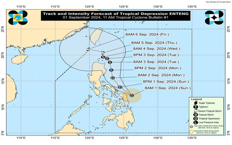
The Philippine Atmospheric, Geophysical, and Astronomical Services Administration (PAGASA) has issued Tropical Cyclone Wind Signal (TCWS) No. 1 for several areas in Luzon and Visayas due to Tropical Depression “Enteng.” The center of “Enteng” was located approximately 120 km North Northeast of Borongan City, Eastern Samar, or 150 km East of Catarman, Northern Samar (12.6°N, 126.0°E).
Current Status and Movement
Tropical Depression “Enteng” is currently moving northwestward at 30 km/h. It has maximum sustained winds of 45 km/h near the center, gustiness of up to 55 km/h, and a central pressure of 1002 hPa. Strong winds extend outward up to 150 km from the center, affecting both land and sea areas under the TCWS No. 1 signal.
Tropical Cyclone Wind Signal No. 1 in Effect
TCWS No. 1 has been raised over the following areas:
- Luzon: Eastern portions of Camarines Sur, Catanduanes, Albay, Sorsogon, Burias Island, and Ticao Island.
- Visayas: Northern Samar, Samar, Eastern Samar, Biliran, and the northeastern portion of Leyte.
Under TCWS No. 1, winds ranging from 39 to 61 km/h (Beaufort 6 to 7) are expected within the next 36 hours, posing a minimal to minor threat to life and property.
Rainfall Warnings and Other Hazards
Heavy rainfall is expected across several regions. From today until tomorrow noon, accumulated rainfall of 100-200 mm is forecasted for areas including Camarines Sur, Catanduanes, Albay, Sorsogon, Masbate, Northern Samar, Samar, Eastern Samar, and Biliran. Rainfall amounts of 50-100 mm are expected in Quezon, Marinduque, Romblon, and other parts of Eastern Visayas.
Flooding and rain-induced landslides are highly likely, particularly in areas that are prone to these hazards or have experienced significant rainfall over the past few days. PAGASA warns residents in these regions to be on high alert and to follow local authorities’ evacuation orders.
The enhanced Southwest Monsoon will also bring moderate to intense rainfall in other parts of Luzon and Visayas, especially in western areas. Strong to gale-force gusts are expected in several regions, including MIMAROPA, Western and Central Visayas, and the Caraga region, over the next 24 to 48 hours.
Maritime Warnings
Moderate to rough seas are expected over the eastern seaboards of Central Luzon and Southern Luzon, Northern Samar, Eastern Samar, and the Kalayaan Islands. Mariners of small sea vessels are advised to avoid navigating these waters, especially if inexperienced or operating ill-equipped vessels.
Track and Intensity Outlook
Tropical Depression “Enteng” is forecasted to continue moving northwestward to north-northwestward over the next 24 hours, with potential intensification into a tropical storm by tomorrow. A landfall over the Bicol Region-Eastern Visayas area is not ruled out. PAGASA will continue to monitor the situation and issue updates as necessary.