The Philippine Atmospheric, Geophysical and Astronomical Services Administration (Pagasa) announced on Thursday afternoon that Tropical Depression Jacinto continues to maintain its strength as it traverses the West Philippine Sea. The weather bureau released its latest advisory.
Current Location and Intensity
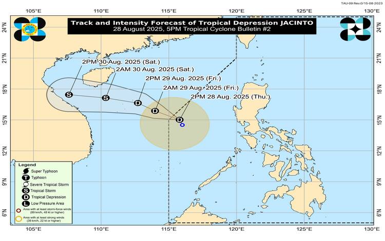
As of 4:00 PM, the center of Jacinto was estimated at 470 kilometers west of Iba, Zambales, at coordinates 15.4°N, 115.6°E. The tropical depression carries maximum sustained winds of 45 kilometers per hour near the center and gustiness of up to 55 km/h, with a central pressure of 1002 hPa. It is currently moving north-northwestward at 10 km/h.
Strong winds extend outward up to 340 kilometers from its center, although Pagasa has not raised any Tropical Cyclone Wind Signals (TCWS) over the country as of this update.
Weather Hazards
Despite the absence of direct cyclone signals, Jacinto continues to enhance the Southwest Monsoon, bringing significant rainfall and strong winds over several regions. Based on Pagasa’s rainfall outlook, intermittent heavy rains are expected, especially over western sections of Northern and Central Luzon and parts of Mimaropa and Visayas.
From today until tomorrow, strong to gale-force gusts are expected over Batanes, Babuyan Islands, the Ilocos Region, the Cordillera Administrative Region, Zambales, Bataan, Mimaropa, Western Visayas, the Negros Island Region, Central Visayas, Dinagat Islands, and Camiguin. By Saturday, gusty winds will persist over Batanes, Babuyan Islands, Pangasinan, Zambales, Lubang Island, Romblon, and Palawan.
Pagasa reminded residents in coastal and upland areas to remain alert against possible flooding, flash floods, and landslides.
Coastal Waters and Sea Conditions
No gale warning is in effect, but rough sea conditions remain a concern. Waves may reach up to 3.5 meters over the northern and western seaboards of the Calamian Islands and parts of Palawan. Meanwhile, moderate to rough seas reaching up to 2.5 meters are expected over Batanes, Babuyan Islands, Zambales, and Occidental Mindoro.
Mariners operating small seacrafts, particularly motorbancas, are advised not to venture into sea travel under these conditions due to heightened risks. Ill-equipped and inexperienced vessels face increased danger from sudden surges and rough waves.
Track and Outlook
Pagasa projects that Jacinto will continue its northwestward track and exit the Philippine Area of Responsibility (PAR) by Thursday evening. Once outside PAR, it will turn west-northwestward across the West Philippine Sea towards northern or central Vietnam. Landfall in Vietnam is likely on Saturday afternoon or evening, where it may bring stronger winds and heavy rainfall.
The system is forecast to gradually consolidate and may intensify into a tropical storm by Friday evening, August 29.
Flood Advisories
Flood advisories have been issued in several regions, including Ilocos Region, Cagayan Valley, Central Luzon, CALABARZON, Mimaropa, Western and Eastern Visayas, and Zamboanga Peninsula. Residents are urged to monitor local government announcements and be prepared for possible evacuation if flooding worsens.
Pagasa continues to monitor Jacinto closely and urges the public to remain vigilant, especially in areas prone to heavy rains, landslides, and sea travel risks.