The Philippine Atmospheric, Geophysical and Astronomical Services Administration (PAGASA) issued its latest advisory on Tropical Depression MirasolPH on Tuesday afternoon, September 17, 2025, as the weather disturbance continued to affect several parts of Northern Luzon.
As of 4:00 p.m., the center of Mirasol was located in the vicinity of Kabugao, Apayao (17.9°N, 121.0°E). It carried maximum sustained winds of 55 km/h near the center, gustiness of up to 90 km/h, and a central pressure of 1002 hPa. The system was moving northwestward at 20 km/h, with strong winds extending outward up to 200 kilometers from the center.
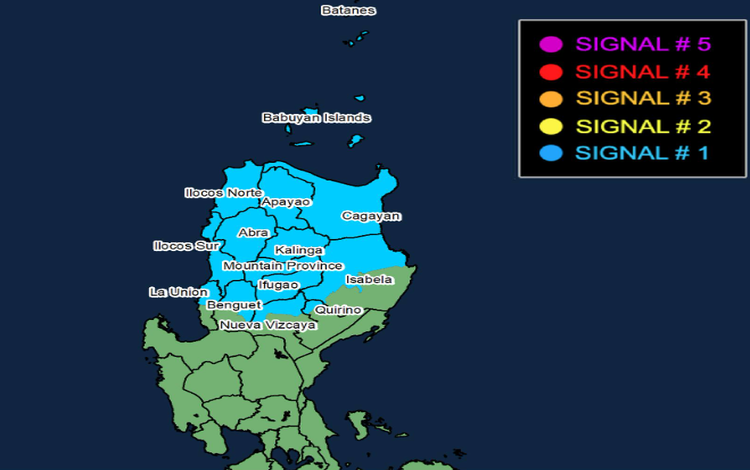
Wind Signals in Effect
Tropical Cyclone Wind Signal (TCWS) No. 1 remains hoisted over parts of Northern and Central Luzon, including Batanes, Cagayan with the Babuyan Islands, Apayao, Abra, Kalinga, Mountain Province, Ilocos Norte, Ilocos Sur, the northern portion of La Union, and the northern portions of Isabela, Quirino, Nueva Vizcaya, and Benguet.
Areas under Signal No. 1 may experience winds ranging from 39 to 61 km/h within 36 hours, posing a minimal to minor threat to life and property. PAGASA noted that winds may be stronger in coastal and upland areas directly exposed to prevailing wind directions.
Rainfall and Flood Risks
Mirasol is expected to bring heavy rainfall across Northern and Central Luzon. PAGASA advised residents to refer to Weather Advisory No. 6 for detailed rainfall outlooks. Multiple General Flood Advisories (GFAs) were also issued at 6:00 p.m. covering the Cordillera Administrative Region, Ilocos Region, Cagayan Valley, Central Luzon, CALABARZON, MIMAROPA, and Western Visayas, among others.
The state weather bureau warned that localized flooding and landslides remain possible, particularly in areas with steep terrain or those already saturated from earlier rains.
Coastal Hazards
Sea travel remains risky in areas directly affected by Mirasol. PAGASA reported moderate to rough seas of up to 3.0 meters along the eastern seaboard of mainland Cagayan and the seaboard of Isabela. Up to 2.5 meters of wave height is expected along the remaining seaboards of Cagayan, Babuyan Islands, Batanes, Aurora, Ilocos Norte, and Ilocos Sur.
Small boats and fishing vessels are strongly advised to avoid venturing into these waters.
Forecast Track and Outlook
Mirasol is projected to continue moving northwestward, crossing Northern Luzon within the next 12 hours before re-emerging over the coastal waters of Ilocos Norte tonight.
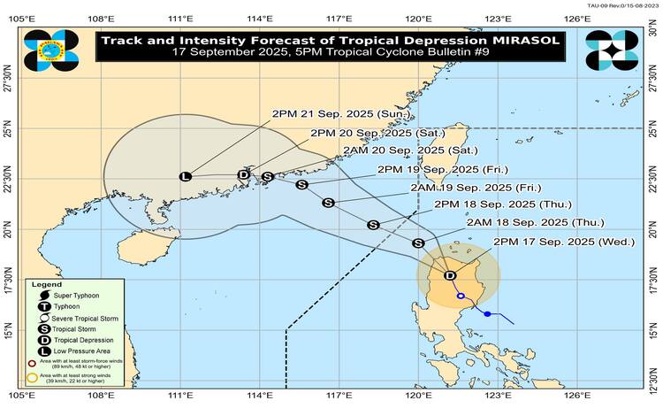
Once over the sea, the system is forecast to intensify into a tropical storm and could potentially strengthen further into a severe tropical storm. PAGASA said Mirasol is likely to exit the Philippine Area of Responsibility (PAR) by Wednesday morning, September 18, 2025.
Meanwhile, the Southwest Monsoon (Habagat) enhanced by Mirasol will continue to bring gusty conditions over Metro Manila, Southern Luzon, and Western Visayas through September 19.
Authorities urge the public to remain vigilant and continue monitoring official weather updates as the cyclone progresses.