The Philippine Atmospheric, Geophysical and Astronomical Services Administration (PAGASA) announced that a new weather disturbance has entered the Philippine Area of Responsibility (PAR) and was given the local name “Opong.” The tropical depression is the latest system to affect the country following the exit of Super Typhoon Nando.
Location and Intensity
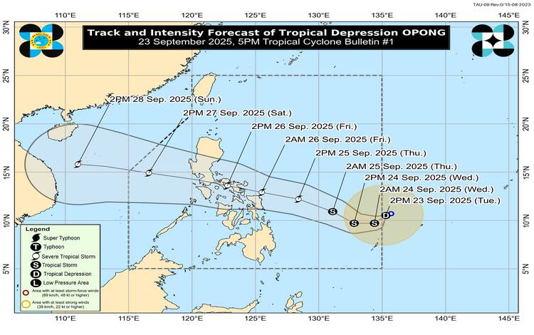
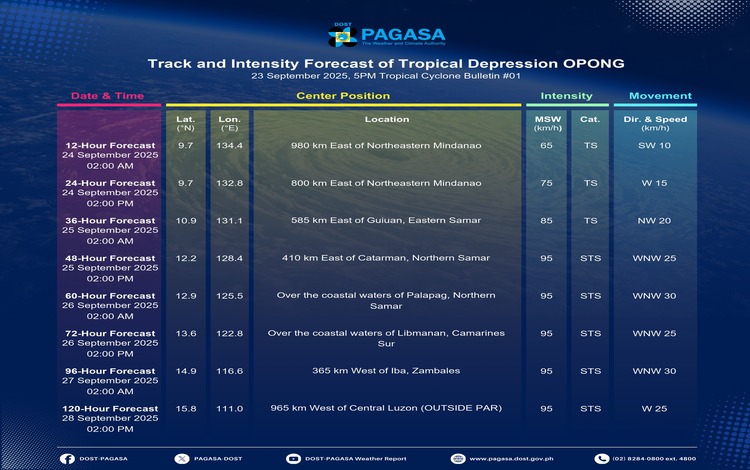
As of 4:00 PM Tuesday, the center of Tropical Depression Opong was estimated at 1,045 kilometers east of Northeastern Mindanao (10.4°N, 135.0°E). The system is currently packing maximum sustained winds of 55 kilometers per hour near the center and gustiness of up to 70 km/h, with a central pressure of 1004 hPa. It is moving west-southwest at 10 km/h.
The depression has a broad circulation, with strong winds extending up to 360 kilometers from its center. At this stage, no tropical cyclone wind signals (TCWS) have been raised over any part of the country.
Rainfall and Wind Outlook
PAGASA said Opong is unlikely to directly affect the weather in most parts of the country within the next 36 hours. However, heavy rainfall may begin to impact areas of Eastern Visayas and Bicol Region starting Thursday, September 25.
Wind Signal No. 1 may be hoisted as early as Wednesday, with the possibility of signals reaching up to Signal No. 3 should Opong strengthen into a severe tropical storm.
The combined influence of Opong, Super Typhoon Nando, and the Southwest Monsoon will generate strong to gale-force gusts across several areas:
- September 24: Most of Luzon, Western Visayas, Surigao del Norte, and Dinagat Islands
- September 25: Batanes, Babuyan Islands, Cagayan, Ilocos Norte, Palawan, Siquijor, Camiguin, Surigao del Norte, Dinagat Islands, Davao Oriental, Davao del Sur, and Davao Occidental
- September 26: Batanes, Babuyan Islands, Cagayan, Ilocos Norte, Siquijor, Northern Mindanao, Caraga, and the Davao Region
Hazards in Coastal Waters
PAGASA warned that moderate to rough seas may affect the eastern coasts of Visayas and Mindanao beginning Thursday afternoon. Gale warnings may follow for Eastern Visayas and Bicol Region as sea conditions worsen to very rough levels.
Additionally, storm surges could trigger coastal inundation in low-lying areas of Southern Luzon and Eastern Visayas, with warnings expected as early as Wednesday.
Track and Intensity Forecast
Based on current projections, Opong will continue its southwestward movement before turning west to west-northwestward, approaching the Eastern Visayas–Southern Luzon corridor. The system may pass close to or make landfall over Northern Samar early Friday, September 26, before crossing Southern Luzon through Friday evening into Saturday morning.
PAGASA noted that Opong is likely to intensify into a severe tropical storm by Thursday and could further strengthen while traversing the Philippine Sea.
Flood Advisories
As of 6:00 PM, PAGASA issued updated General Flood Advisories for multiple regions, including NCR (GFA#4), Cordillera (GFA#8), Ilocos Region (GFA#8), and CALABARZON (GFA#8). Final advisories were released for Cagayan Valley (GFA#7) and Western Visayas (GFA#7).
Authorities are advising residents, especially in flood-prone and coastal communities, to monitor official bulletins and prepare for possible heavy rainfall, strong winds, and coastal hazards in the coming days.