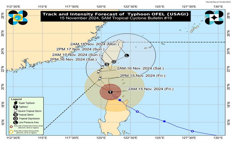
Typhoon “Ofel” (international name: Usagi) has been tracked over the Luzon Strait, approximately 100 kilometers northwest of Calayan, Cagayan (coordinates 19.8°N, 120.7°E). Ofel’s intensity continues to diminish as it moves north-northwestward at 20 km/h, with maximum sustained winds of 120 km/h near the center, gustiness reaching up to 150 km/h, and a central pressure of 975 hPa. The typhoon’s strong to typhoon-force winds extend up to 340 km from its center.

Tropical Cyclone Wind Signals in Effect
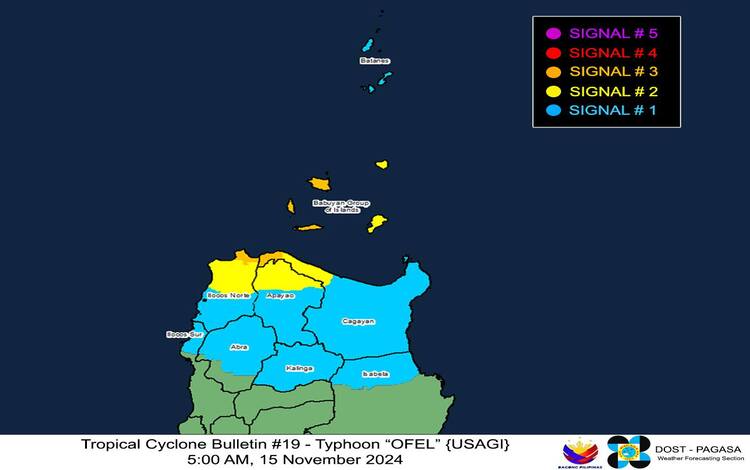
Pagasa has raised Tropical Cyclone Wind Signals (TCWS) across various regions in Northern Luzon, as outlined below:
- TCWS No. 3: Areas under this signal, including the western portion of Babuyan Islands, the northwesternmost part of Cagayan (Claveria, Santa Praxedes), and the northernmost areas of Ilocos Norte (Pagudpud), are expected to experience storm-force winds within 18 hours. Winds range from 89 to 117 km/h, posing a moderate to significant threat to life and property.
- TCWS No. 2: Gale-force winds are expected within 24 hours in areas such as the rest of Babuyan Islands, the northwestern Cagayan (Sanchez-Mira, Pamplona, Abulug, Ballesteros), parts of Apayao (Calanasan, Luna, Santa Marcela), and additional northern parts of Ilocos Norte (Piddig, Bacarra, Adams, Dumalneg, and Vintar). Winds of 62 to 88 km/h are anticipated, with the potential for minor to moderate impacts on life and property.
- TCWS No. 1: Strong winds may impact Batanes, parts of Cagayan, northern Isabela, and other regions within 36 hours. Wind speeds range from 39 to 61 km/h, with minimal to minor threats to life and property.

Rainfall and Wind Hazards
Residents in affected areas should refer to Weather Advisory No. 36, which details rainfall projections not only from Typhoon Ofel but also from Tropical Depression Pepito, which is expected to enhance rain-bearing winds. Heavy rains and strong winds pose risks of flash floods and landslides, especially in mountainous regions. Areas under TCWS No. 3 may face significant impacts, while minor to moderate effects are expected in areas under TCWS No. 2.
In addition to wind hazards, coastal areas face risks from storm surges, with anticipated peak heights of up to 3.0 meters in the next 48 hours. The affected regions include low-lying coastal communities in Batanes, Ilocos Norte, Ilocos Sur, Cagayan (including the Babuyan Islands), and Isabela. Communities are urged to heed Storm Surge Warning No. 11 and take necessary safety precautions.
Sea Conditions and Gale Warnings
Rough seas, with wave heights reaching up to 5.0 meters, are expected around the seaboards of Batanes and Babuyan Islands. The northern coastlines of Ilocos Norte and Cagayan can expect waves as high as 4.5 meters. Gale Warning No. 6 advises all vessels, regardless of tonnage, to remain in port until weather conditions stabilize. Smaller vessels, particularly motorbancas, should avoid navigating in rough waters, especially around the eastern seaboard of Cagayan and parts of Isabela where waves are estimated at 4.0 meters.
Track and Intensity Outlook
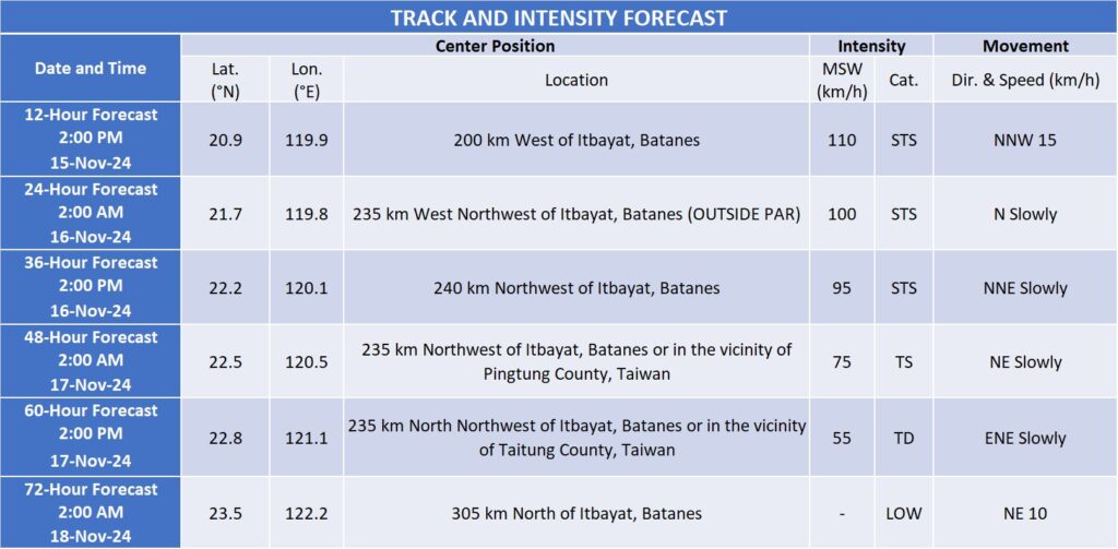
Pagasa forecasts that Typhoon Ofel will continue its north-northwest path, exiting the Philippine Area of Responsibility (PAR) by this afternoon. However, despite moving away, parts of Extreme Northern Luzon may still experience elevated wind threats due to Ofel’s influence. The typhoon is expected to weaken as it encounters less favorable environmental conditions in the Luzon Strait and the waters east of Taiwan. By November 16, Ofel may transition into a low-pressure system and could re-enter PAR, veering northeastward toward Taiwan.

Safety Advisories
Pagasa advises residents in affected regions to remain vigilant, follow local disaster protocols, and prepare for potential power outages, road closures, and other storm-related disruptions. Fisherfolk and mariners are especially cautioned to prioritize safety, while travelers are advised to confirm road and sea transport availability before venturing into affected areas.
As Ofel weakens, updates from Pagasa will continue to track its impact on Northern Luzon. Residents are urged to stay tuned for the latest advisories on rainfall, wind hazards, and coastal warnings, ensuring that safety measures are maintained during the typhoon’s remaining influence.
