The Philippine Atmospheric, Geophysical and Astronomical Services Administration (PAGASA) released its latest weather bulletin at 2:00 AM on February 7, 2026, reporting that Tropical Depression Basyang (international name Penha) has weakened into a Low Pressure Area (LPA) while remaining inside the Philippine Area of Responsibility (PAR). Despite the weakening, the weather disturbance continues to bring rain, gusty winds, and rough sea conditions in several parts of the country.
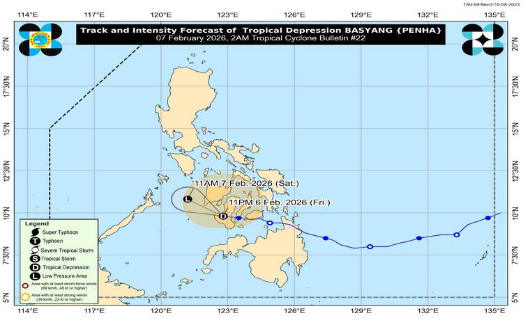
According to PAGASA, the center of Basyang was last estimated in the vicinity of Cauayan, Negros Occidental (9.9°N, 122.6°E). The system currently carries maximum sustained winds of 45 kilometers per hour near the center, with gustiness reaching up to 60 kilometers per hour and a central pressure of 1004 hPa. It is moving westward at 15 kilometers per hour and is forecast to continue traveling in a west-northwest direction toward the southern portion of Panay Island or Panay Gulf.
Weather authorities noted that Basyang is unlikely to redevelop into a tropical depression within the next 24 hours. However, its wide wind circulation, extending up to 250 kilometers from the center, continues to influence weather conditions across parts of Luzon and the Visayas.
Tropical Cyclone Wind Signals in Effect
Tropical Cyclone Wind Signal (TCWS) No. 1 remains in effect over several areas, indicating strong winds ranging from 39 to 61 km/h, with possible minimal to minor impacts on life and property.
Areas under TCWS No. 1 include Cuyo and Cagayancillo Islands in Luzon, as well as multiple areas in the Visayas such as Bohol, Cebu, Siquijor, Negros Oriental, Negros Occidental, Guimaras, Iloilo, Capiz, Aklan, Antique, and portions of Leyte and Southern Leyte.
PAGASA warned that local wind conditions may be stronger in coastal and mountainous areas exposed to prevailing winds. Additionally, the surge of the Northeast Monsoon, locally known as Amihan, may bring strong to gale-force gusts across most of Luzon, Western Visayas, and parts of Negros Island Region in the coming days.
Heavy Rainfall and Flooding Risks
While Basyang is weakening, heavy rainfall remains a major concern, especially in areas already saturated by previous rains. PAGASA advised residents to stay alert for possible flash floods, landslides, and localized flooding, particularly in low-lying and mountainous areas. Authorities continue to monitor rainfall outlooks through issued weather advisories across several regions, including MIMAROPA, Bicol Region, Western Visayas, Central Visayas, Eastern Visayas, and parts of Mindanao.
Sea Travel Warnings
Coastal waters remain hazardous due to strong winds and rough seas. PAGASA warned of very rough sea conditions reaching up to 4.5 meters along the seaboards of Batanes, while rough seas are expected in other northern and eastern coastal areas, including the Babuyan Islands and parts of Northern Samar and Eastern Visayas.
Mariners operating small vessels and motorized bancas are strongly advised not to venture out to sea, especially in high-risk areas. Larger vessels are also urged to remain cautious and seek safe harbor if necessary.
PAGASA expects Basyang to further weaken into a low-pressure system within the next 12 hours. Nevertheless, residents are advised to continue monitoring official weather updates as the system may still trigger rainfall and gusty winds beyond its forecast track.
Local government units and disaster response agencies remain on alert to ensure public safety as Basyang continues to influence weather conditions across affected regions.