MANILA, Philippines – Tropical Storm “RAMIL” (international name: FENGSHEN) has successfully traversed the Luzon landmass and is now situated over the West Philippine Sea, according to the latest bulletin issued by the Philippine Atmospheric, Geophysical and Astronomical Services Administration (PAGASA) on Saturday, October 19, 2025.
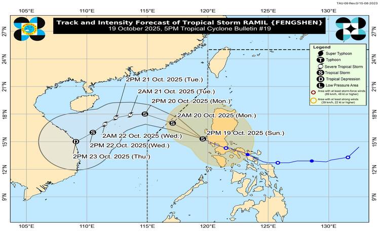
The shift in location marks a significant turning point in the storm’s path, as weather authorities forecast a possible re-intensification to a Severe Tropical Storm category once it moves farther from the Philippine landmass.
Current Status and Movement
As of 4:00 PM today, the center of Tropical Storm RAMIL was estimated to be 85 km west-northwest of Iba, Zambales. The storm maintains its strength with maximum sustained winds of 65 km/h near the center and gustiness of up to 80 km/h. The central pressure is recorded.
RAMIL is currently moving west-northwest at a swift 35 km/h, accelerating its trajectory towards exiting the Philippine Area of Responsibility (PAR). PAGASA projects the storm will officially be outside PAR by tomorrow (October 20) morning.
Wind Signals and Hazard Warnings
While the storm is moving away, Tropical Cyclone Wind Signals (TCWS) remain in effect for several parts of Luzon, warning residents of continued strong winds and associated hazards.
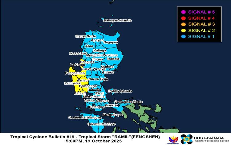
TCWS No. 2—indicating a threat of gale-force winds is currently hoisted over the central and southern portions of La Union, western and central Pangasinan, Zambales, Tarlac, the western portion of Pampanga, and the northern portion of Bataan. Residents in these areas must brace for minor to moderate threats to life and property within the next 24 hours.
TCWS No. 1 is in effect across a far broader area, including Metro Manila, Cagayan, Isabela, Ilocos Norte, Ilocos Sur, the rest of Central Luzon, CALABARZON, and portions of MIMAROPA and Camarines Norte. These regions face minimal to minor impacts from strong winds within a 36-hour warning lead time.
Heavy Rainfall and Coastal Threats
Local authorities are strongly advising the public to remain vigilant against potential secondary impacts. The trough and outer rainbands of RAMIL, along with the easterlies, are expected to bring strong to gale-force gusts over areas not directly under a wind signal, including the Bicol Region and Eastern Visayas today, and Central Luzon, Metro Manila, and CALABARZON tomorrow.
Furthermore, a Storm Surge Warning No. 10 indicates a minimal to moderate risk of storm surge, with peak heights of 1.0 to 2.0 meters over low-lying coastal localities in Ilocos Sur, La Union, Pangasinan, Zambales, Bataan, Batangas, Cavite, and Occidental Mindoro.
Sea travel remains extremely risky. A Gale Warning is in effect over the western seaboard of Luzon, with sea conditions expected to reach very rough seas (up to 4.5 meters) over the western seaboards of Pangasinan, Zambales, Bataan, Batangas, and Lubang Island. All mariners are advised to remain in port.
As the storm moves into the open West Philippine Sea and is poised for re-intensification, PAGASA continues to monitor the situation closely, urging all affected residents to heed official General Flood Advisories (GFAs) and local government instructions. The storm’s trajectory suggests its threat to the country will diminish as it tracks further away, but its lingering effects, particularly rainfall and coastal hazards, require continued caution.