MANILA, Philippines — The Philippine Atmospheric, Geophysical, and Astronomical Services Administration (PAGASA) released its 3:00 PM weather forecast for October 21, 2025, highlighting the persistence of the Easterlies and the impact of the Intertropical Convergence Zone (ITCZ) on various parts of the country.
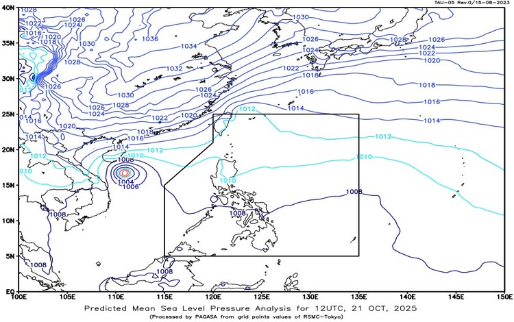
A notable weather feature is a Low Pressure Area (LPA) detected outside the Philippine Area of Responsibility (PAR), estimated at 435 km north-northeast of Itbayat, Batanes. While currently not a direct threat, its proximity and movement will continue to be monitored.
Adding to the dynamic situation is the presence of Severe Tropical Storm Fengshen (formerly “Ramil”) well outside the PAR, located 905 km West of Northern Luzon. Packing maximum sustained winds of 95 km/h near the center and gusts up to 115 km/h, Fengshen is moving westward at 10 km/h, steering it further away from the archipelago.
Rainfall Forecast and Concerns
The main rainfall threats are concentrated in the central and southern regions. Cloudy skies with scattered rains and thunderstorms are forecast for the Negros Island Region, Central Visayas, Zamboanga Peninsula, Northern Mindanao, SOCSSKARGEN, BARMM, and Davao Region. This adverse weather is attributed to the Intertropical Convergence Zone (ITCZ), prompting warnings of possible flash floods or landslides during moderate to, at times, heavy rains.
Meanwhile, the Bicol Region, Eastern Visayas, Caraga, Aurora, and Quezon will experience partly cloudy to cloudy skies with isolated rainshowers or thunderstorms due to the prevailing Easterlies. Isolated rainshowers are also expected for Batanes, caused by a Northeasterly Windflow, and for Metro Manila and the rest of the country due to Localized Thunderstorms. Residents in all these areas are advised to take precautions against possible flash floods or landslides, especially during severe thunderstorms.
Coastal and Marine Conditions
Sea conditions vary across the country. Extreme Northern Luzon is under a warning for rough coastal waters with wave heights reaching 2.8 to 4.0 meters, driven by strong Northeast winds. Northern Luzon will see moderate rough waters (1.2 to 2.5 meters) with mild to strong East to Northeast winds. Mariners in the rest of the country can expect calmer seas, with slight to moderate coastal waters (0.6 to 1.8 meters) and light to moderate winds from the Northeast to the South.
PAGASA also issued General Flood Advisories (GFA) for regions 6, 7, 8, 9, 10, 11, 12, 13, and BARMM, underscoring the risk of flooding in these areas. The maximum temperature recorded for the 24 hours ending 4:00 PM today at 1:00 PM, indicative of the high heat and moisture content in the atmosphere, with maximum relative humidity peaking early this morning.