The Low-Pressure Area (LPA) east of Extreme Northern Luzon has intensified into a Tropical Depression, now named Igme. This development prompts PAGASA to issue its first tropical cyclone bulletin regarding the system’s current status and potential impacts.
Location and Intensity
As of 4:00 PM today, the center of Tropical Depression Igme was estimated to be 530 kilometers east-northeast of Itbayat, Batanes, at coordinates 22.6°N, 126.6°E. The tropical depression is packing maximum sustained winds of 55 km/h near its center, with gusts reaching up to 70 km/h. The central pressure has been recorded at 1004 hPa, indicating its strength as a typical tropical depression. The system is moving in a northwestward direction at a speed of 15 km/h.
Wind Extent and Coverage
Strong winds extend outward up to 720 kilometers from the center of Igme, making the system a considerable threat even to areas that may not directly experience its core winds. Areas within its vicinity are likely to experience enhanced winds over the coming days, with the immediate concern being regions under the signal warnings.
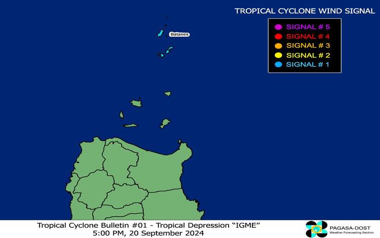
Tropical Cyclone Wind Signal (TCWS) in Effect
PAGASA has placed the province of Batanes under TCWS No. 1. This signal indicates that winds between 39 and 61 km/h, or roughly equivalent to Beaufort scale levels 6 to 7, can be expected within 36 hours. The forecasted wind speeds under this signal are considered to pose minimal to minor threats to life and property. Residents should prepare for possible impacts such as minor damage to lightweight structures and small tree branches breaking.
Hazards Affecting Land Areas
- Heavy Rainfall
While Igme is not expected to bring significant direct rainfall, the system is enhancing the Southwest Monsoon, which will trigger downpours in several areas. The latest advisory, Weather Advisory No. 41, issued at 5:00 PM today, includes details on the expected rainfall due to the combined effects of Igme and the monsoon. - Severe Winds
Coastal and upland areas exposed to winds are expected to experience enhanced wind gusts due to Igme. The provinces of Ilocos Region, Batanes, Babuyan Islands, Zambales, and Bataan are likely to face strong to gale-force gusts starting today. These conditions will persist until Wednesday, 22 September, when the tropical depression is expected to continue its influence over the region.
Hazards Affecting Coastal Waters
The sea condition outlook for the next 24 hours is concerning for mariners. Moderate to rough seas, with wave heights ranging from 1.5 to 3.5 meters, are expected along the seaboards of Northern and Central Luzon, as well as the western seaboard of Southern Luzon. Mariners, particularly those operating small seacrafts or motorbancas, are advised to refrain from venturing into these waters due to the hazardous conditions.
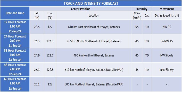
Track and Intensity Outlook
Tropical Depression Igme is forecast to maintain its current strength as it tracks generally west-northwestward until Sunday morning, 22 September. By this time, Igme is expected to begin turning north-northeastward. On its forecast path, a landfall in Taiwan remains a possibility. However, Igme is expected to exit the Philippine Area of Responsibility (PAR) by Sunday.
While no significant intensification is expected, there is a chance that Igme may gradually weaken into a low-pressure area before exiting PAR.
Stay tuned for the next bulletin at 11:00 PM today, and monitor advisories for updated information.