January 15, 2026 — Manila, Philippines
The Philippine Atmospheric, Geophysical and Astronomical Services Administration (PAGASA) reported early Thursday that Tropical Depression Ada (#AdaPH) has slightly intensified while continuing its movement over the Philippine Sea east of Mindanao, bringing strong winds, heavy rainfall, and dangerous sea conditions to several regions across the country.
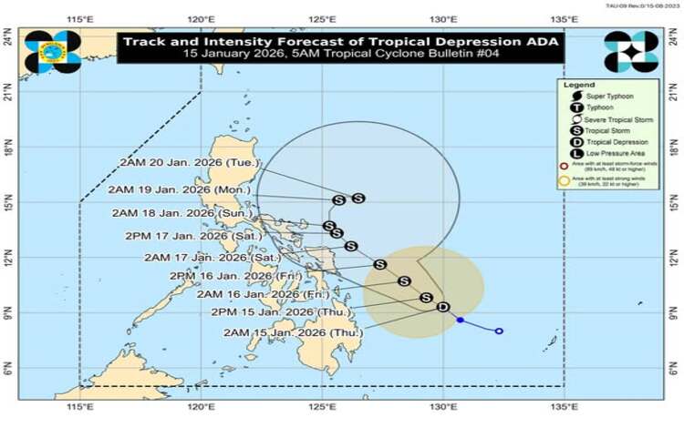
As of 4:00 a.m., the center of Tropical Depression Ada was located approximately 385 kilometers east-northeast of Hinatuan, Surigao del Sur, or about 465 kilometers east of Surigao City, with coordinates at 9.4°N, 129.7°E.
Strength and Movement
Ada now carries maximum sustained winds of 55 kilometers per hour with gusts reaching up to 70 km/h, and a central pressure of 1000 hectopascals. The weather system is moving northwestward at 20 km/h, with its strong winds extending outward up to 400 km from the center.
PAGASA forecasts that Ada will strengthen into a tropical storm later today and continue to intensify in the coming days gradually.
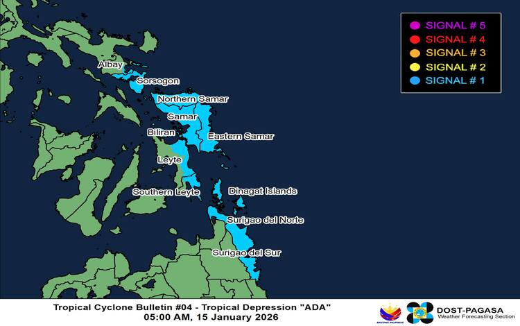
Areas Under Wind Signal No. 1
Tropical Cyclone Wind Signal No. 1 remains in effect over parts of Luzon, Visayas, and Mindanao, including:
- Luzon: Sorsogon and southeastern Albay
- Visayas: Northern Samar, Samar, Eastern Samar, eastern Biliran, eastern Leyte, and eastern Southern Leyte
- Mindanao: Dinagat Islands, Surigao del Norte, and Surigao del Sur
Under this signal, residents may experience strong winds between 39 and 61 km/h, posing minimal to minor threats to life and property.
The highest possible signal that may be raised as Ada progresses is Wind Signal No. 2, according to PAGASA.
Severe Winds and Heavy Rainfall Threat
Beyond the direct path of Ada, the Northeast Monsoon and the storm’s outer rainbands will produce strong to gale-force gusts across wide portions of Northern Luzon, CALABARZON, Bicol Region, Visayas, and Caraga through Saturday.
PAGASA has also issued multiple General Flood Advisories across Regions 3, 4A, 5, 7, 8, 10, 11, 12, 13, and BARMM, warning of possible flooding and landslides, especially in low-lying and mountainous areas.
Dangerous Sea Conditions
Coastal waters in eastern sections of the country are expected to become rough to very rough, with waves reaching up to 4 meters along the seaboards of Catanduanes, Northern Samar, Eastern Samar, Dinagat Islands, and Siargao.
Authorities strongly advise small sea vessels and motorbancas to avoid venturing into open waters as these conditions pose extreme danger to navigation.
Forecast Track
Ada is expected to continue moving northwest through Sunday before turning north-northeast by Monday. PAGASA warns that the storm could pass near Eastern Samar and Northern Samar by Friday or early Saturday, then move close to Catanduanes by Sunday. A westward shift could bring possible landfall over Eastern Visayas or the Bicol Region.
Officials urge residents in affected areas to remain alert, monitor official weather bulletins, and follow evacuation and safety protocols as the situation develops.