Typhoon “TINO” has slightly intensified as it charges westward, now posing a significant to severe threat to life and property across parts of Eastern Visayas and CARAGA. Residents in the path of the powerful weather system are strongly advised to complete all necessary preparations immediately.
Typhoon Track and Intensity
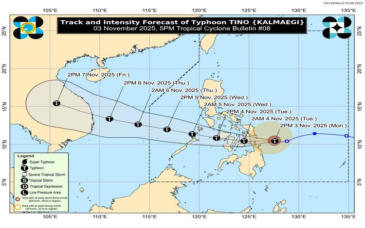
As of the 4:00 PM position, the eye of Typhoon “TINO” (International Name: KALMAEGI) was located approximately 170 km east-southeast of Guiuan, Eastern Samar.
Maximum Sustained Winds: 130 km/h near the center.
Gustiness: Up to 160 km/h
Central Pressure: 970 h
Movement: Westward at 20km/h
Wind Extent: Strong to typhoon-force winds extend up to 300km from the center.
Landfall Alert: TINO is forecast to make its initial landfall or pass very close to Homonhon Island or Dinagat Islands tonight or early tomorrow morning (04 November). It is then expected to cross over Leyte or Southern Leyte shortly after, traversing the Visayas and northern Palawan throughout tomorrow until Wednesday morning (05 November). The typhoon is expected to emerge over the West Philippine Sea on Wednesday and exit the Philippine Area of Responsibility by Thursday morning (06 November).
Crucial Warning: TINO is forecasted to make its initial landfall at or near its peak intensity (estimated 140-155 km/h, with rapid intensification still considered likely before it hits land. Despite expected weakening from terrain interaction, TINO is projected to maintain Typhoon status throughout its passage across the country.
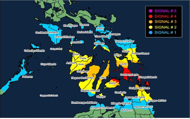
VISAYAS: Extreme southeastern portion of Eastern Samar (Guiuan), Southern Leyte, southern portion of Leyte (Mahaplag, Abuyog, City of Baybay, Inopacan, Hilongos, Hindang, Bato, Matalom, Javier), Camotes Islands, and the northeastern portion of Bohol. MINDANAO: Dinagat Islands, Siargao, and Bucas Grande Islands.
3
Much of the central Visayas, Biliran, Siquijor, Capiz, Iloilo, Aklan, Antique, parts of southern Masbate, southern Romblon, Cuyo Islands, and Northern Mindanao areas, including northern Surigao del Sur, Agusan del Sur, Agusan del Norte, and Camiguin.
Large portions of Eastern Samar, Samar, Leyte, Cebu, Bohol, northern Negros Oriental and Occidental, Guimaras, eastern Iloilo, and the rest of Surigao del Norte.
2
VISAYAS: Extreme southeastern portion of Eastern Samar (Guiuan), Southern Leyte, southern portion of Leyte (Mahaplag, Abuyog, City of Baybay, Inopacan, Hilongos, Hindang, Bato, Matalom, Javier), Camotes Islands, and the northeastern portion of Bohol. MINDANAO: Dinagat Islands, Siargao, and Bucas Grande Islands.
VISAYAS: Extreme southeastern portion of Eastern Samar (Guiuan), Southern Leyte, southern portion of Leyte (Mahaplag, Abuyog, City of Baybay, Inopacan, Hilongos, Hindang, Bato, Matalom, Javier), Camotes Islands, and the northeastern portion of Bohol. MINDANAO: Dinagat Islands, Siargao, and Bucas Grande Islands.
1
VISAYAS: Extreme southeastern portion of Eastern Samar (Guiuan), Southern Leyte, southern portion of Leyte (Mahaplag, Abuyog, City of Baybay, Inopacan, Hilongos, Hindang, Bato, Matalom, Javier), Camotes Islands, and the northeastern portion of Bohol. MINDANAO: Dinagat Islands, Siarga, and Bucas Grande Islands.
Expanded areas in Luzon (Albay, Sorsogon, Masbate, Romblon, Oriental/Occidental Mindoro, Palawan) and the rest of Mindanao.
Accompanying Hazards
Storm Surge and Coastal Flooding
There is a HIGH RISK of life-threatening and damaging storm surges with peak heights exceeding 3.0m over low-lying or exposed coastal communities within the next 48 hours. This applies to coastlines in Masbate, Romblon, Oriental/Occidental Mindoro, Palawan, ALL of Visayas, Dinagat Islands, Surigao del Norte/Sur, Agusan del Norte, Misamis Oriental, and Camiguin.
Heavy Rainfall
For the most current and detailed rainfall forecast due to the combination of TINO and the Shear Line, the public is advised to consult Weather Advisory No. 9 issued at 5:00 PM today.
Sea Travel Risk
A Gale Warning is in effect. Sea travel is risky for all types of vessels across all seaboards of the Visayas, the eastern and southern seaboards of Southern Luzon, and the northern and eastern seaboards of Mindanao. Wave heights can reach up to 9.0m on the eastern seaboard of Eastern Samar. Mariners must remain in port or seek immediate safe harbor.
Public Safety Advisory
Residents in areas under TCWS No. 4 and 3 must brace for significant structural damage, massive power outages, and widespread tree fall. Immediate preemptive evacuation in low-lying and coastal areas, especially those prone to storm surge, is highly recommended. All residents are urged to monitor updates from PAGASA and local disaster risk reduction and management councils (DRRMC).
⚠️ GENERAL FLOOD ADVISORIES (GFA) IN EFFECT ⚠️
PAGASA has issued a General Flood Advisory (GFA) across multiple regions, reflecting the serious threat of widespread flooding and rain-induced landslides due to Typhoon TINO and the prevailing Shear Line.
Hazard Level
Regions Under GFA
Significance
GFA #3 (High Risk)
Region 4A (CALABARZON), Region 5 (Bicol Region), Region 7 (Central Visayas), Region 8 (Eastern Visayas), Region 13 (CARAGA)
Indicates that flooding is SERIOUSLY THREATENING in low-lying areas and near river channels, with a high threat of LANDSLIDES in mountainous/hilly areas.
GFA #2 (Moderate Risk)
Region 3 (Central Luzon), Region 4B (MIMAROPA), Region 6 (Western Visayas), Region 10 (Northern Mindanao)
Indicates that flooding is THREATENING in low-lying areas and near river channels, and LANDSLIDES are threatening in landslide-prone areas.
GFA #1 (Minimal Risk)
NCR (National Capital Region), Region 9 (Zamboanga Peninsula), BARMM
Indicates that POSSIBLE flooding in low-lying areas and near river channels, and LANDSLIDES in mountainous areas.