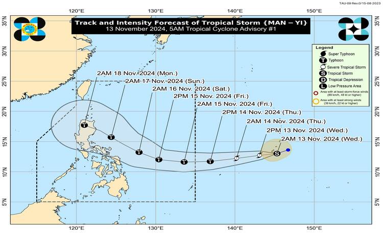
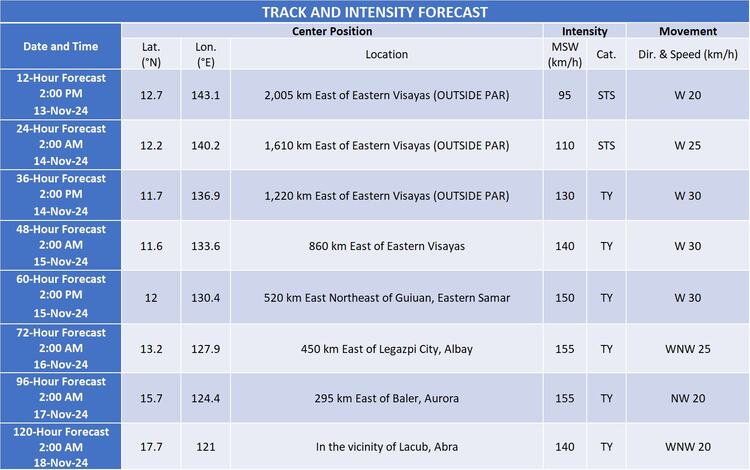
The Philippine Atmospheric, Geophysical, and Astronomical Services Administration (Pagasa) has issued an update on Tropical Storm MAN-YI, locally named Pepito, which remains south of Guam, steadily moving west-southwestward. As of 4:00 AM today, the storm was located approximately 2,210 km east of Eastern Visayas, outside the Philippine Area of Responsibility (PAR). MAN-YI currently carries maximum sustained winds of 75 km/h, gusts reaching 90 km/h, and a central pressure of 998 hPa. The tropical storm is advancing west-southwestward at a speed of 30 km/h, with strong to gale-force winds extending up to 270 km from its center.

Forecast Path and Intensity
Pagasa projects that MAN-YI, influenced by a high-pressure area south of Japan, will continue moving southwestward over the next 12 hours. It is expected to shift to a more westward path as it approaches the eastern boundary of PAR, potentially entering Philippine waters tomorrow evening, November 14. On its projected course, MAN-YI may make landfall over Northern or Central Luzon by Sunday, November 17, in the afternoon or evening.
According to Pagasa, MAN-YI is likely to intensify to a severe tropical storm by the end of today and could escalate further into a typhoon by tomorrow afternoon or evening. There remains a possibility of rapid intensification as it traverses the warm waters of the Philippine Sea. While not definite, forecasters do not rule out the potential for MAN-YI to reach super typhoon strength before making landfall, especially if it follows optimal conditions for intensification.
Despite uncertainty in its exact landfall location, MAN-YI’s broad reach and strength will likely result in hazardous weather impacts across Luzon. Pagasa emphasizes that areas outside the direct landfall point may still experience the storm’s effects, including strong winds and hazardous coastal conditions.
Potential Hazards and Affected Areas
Pagasa warns that, although the storm is still far from Philippine territory, residents in Northern Luzon should brace for possible heavy rainfall, severe winds, and coastal inundation due to potential storm surges. The eastern parts of Central and Southern Luzon could also be affected, particularly if the cyclone broadens in size or shifts to a more southerly track. MAN-YI’s impacts, therefore, may span a wider area than initially projected, especially if the system intensifies as expected.
In addition to wind and rainfall, MAN-YI is expected to create dangerous sea conditions along several seaboards. Starting on Saturday, November 16, the northern and eastern seaboards of the Bicol Region and Eastern Visayas will experience moderate to rough seas, with conditions potentially worsening as the storm nears. By Sunday, the affected areas will likely extend to the eastern seaboards of Central and Southern Luzon, and the entire seaboard of Northern Luzon. Fisherfolk and small vessel operators are advised to avoid venturing into these waters until conditions normalize.

Preparedness and Monitoring
Given the storm’s potential impact, Pagasa encourages residents, particularly those in Luzon’s coastal and mountainous regions, to stay updated on official weather advisories and bulletins. Local government units are advised to prepare for the possibility of evacuations or other necessary precautions, particularly in flood- and landslide-prone areas. Those living near shorelines and low-lying areas should remain vigilant for the possibility of storm surge flooding.
Pagasa will continue to closely monitor MAN-YI’s development and provide updates as new data becomes available. The agency urges the public to follow reputable weather sources and adhere to advisories for safety.
