The Philippine Atmospheric, Geophysical and Astronomical Services Administration (PAGASA) announced on Wednesday, October 8, 2025, that Tropical Storm “NAKRI” may enter the northeastern boundary of the Philippine Area of Responsibility (PAR) by Thursday afternoon or evening. Once inside PAR, the weather system will be given the local name “QUEDAN.”
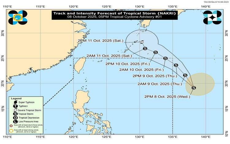
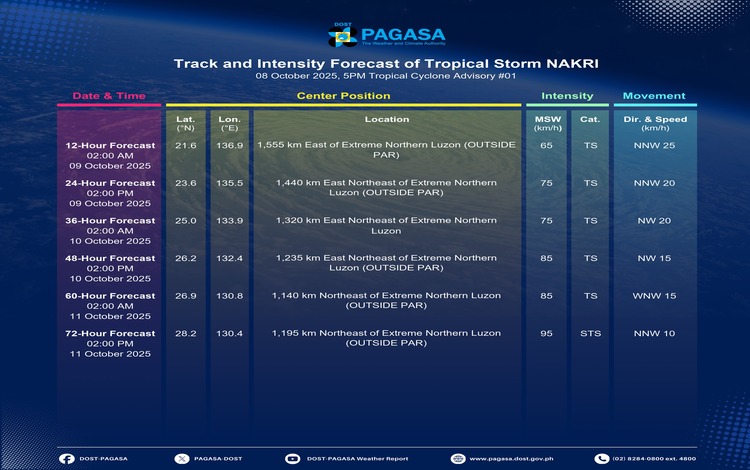
As of 4:00 p.m., the center of Tropical Storm NAKRI was located approximately 1,725 kilometers east of extreme northern Luzon, outside the PAR, at coordinates 19.7°N, 137.9°E. The storm currently packs maximum sustained winds of 65 kilometers per hour (km/h) near the center, gustiness of up to 80 km/h, and a central pressure of 1002 hPa. It is moving north-northwestward at a speed of 25 km/h, with strong to gale-force winds extending up to 380 kilometers from its center.
According to PAGASA’s forecast, NAKRI is expected to continue tracking generally north-northwestward to northwestward over the next 24 hours. The weather disturbance is predicted to enter PAR on October 9 and exit by early morning on October 10. By Saturday, October 11, it may intensify into a severe tropical storm as it heads toward the Ryukyu Islands of Japan.
PAGASA emphasized that NAKRI, or QUEDAN, once it enters PAR, is less likely to directly impact the country’s weather and sea conditions throughout the forecast period. Hence, no Tropical Cyclone Wind Signal is expected to be raised. However, the combined influence of the Intertropical Convergence Zone (ITCZ) and the northeasterly wind flow will bring strong to gale-force gusts across various regions.
On Thursday, gusty conditions may affect Batanes, the Babuyan Islands, Ilocos Norte, Palawan, and parts of Visayas and Mindanao, including the Negros Island Region, Central Visayas, and Northern Mindanao. By Friday, areas such as Eastern Samar, Dinagat Islands, Surigao del Norte, and Davao Oriental may experience similar winds. On Saturday, gusts are expected to persist in parts of Western Visayas, Central Visayas, and northern Mindanao provinces.
PAGASA continues to advise fishermen and small vessel operators, especially in the affected regions, to remain cautious of potentially rough seas and to monitor further weather updates as NAKRI nears the Philippine boundary.