The Philippine Atmospheric, Geophysical and Astronomical Services Administration (PAGASA) has issued its weather forecast for February 13, 2026, warning of scattered rains and thunderstorms affecting multiple regions of the country. The forecast highlights the combined effects of a Shear Line in Eastern Southern Luzon, the Northeast Monsoon over much of Luzon, and easterly winds impacting other areas. Residents are advised to remain vigilant for potential flash floods and landslides due to moderate to occasionally heavy rainfall.
In the Bicol Region and parts of Southern Luzon, including Isabela, Quirino, Aurora, Quezon, Rizal, Laguna, Batangas, Oriental Mindoro, Marinduque, and Romblon, cloudy skies with scattered rain showers and isolated thunderstorms are expected. The Shear Line in the area is contributing to unstable weather conditions, with potential flash floods or landslides in vulnerable locations. PAGASA urges residents in these areas to monitor river levels and avoid low-lying or flood-prone zones.
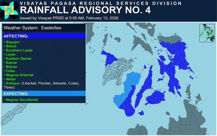
Meanwhile, Visayas, Northern Mindanao, Caraga, the Davao Region, and SOCCSKSARGEN are experiencing cloudy conditions with scattered rains and thunderstorms caused by easterly winds. These weather systems can trigger localized flooding and landslides, particularly in areas with previous rainfall accumulation. Provinces like Negros Occidental, Siquijor, Bohol, Southern Leyte, Leyte, Eastern Samar, Samar, Biliran, Cebu, Negros Oriental, Aklan, and parts of Antique—including Libertad, Pandan, Sebaste, Culasi, and Tibiao—are under an active rainfall advisory, as moderate to occasionally heavy rains may persist over the next few hours.
In Northern Luzon, including Cagayan Valley, Apayao, Kalinga, Mountain Province, and Ifugao, lighter rainfall is expected due to the influence of the Northeast Monsoon. While weather conditions remain mostly manageable, occasional light showers may occur, though no significant impacts are anticipated. Similarly, Metro Manila, the Ilocos Region, Central Luzon, and other parts of the Cordillera Administrative Region will see partly cloudy to cloudy skies with isolated light rain, posing minimal risk to the general public.
Wind conditions vary across the country. Northern Luzon and the eastern sections of Central and Southern Luzon are experiencing moderate to strong northeast winds, with coastal waters ranging from moderate to rough, measuring 1.2 to 2.5 meters. In other regions, winds are generally light to moderate from the east to northeast, with coastal waters mostly slight to moderate at 0.6 to 2.1 meters. Mariners and coastal communities are advised to exercise caution, particularly in northern and eastern coastal waters.
As of 2:00 AM on February 13, PAGASA confirms that no Low Pressure Areas (LPA) are being monitored for tropical cyclone formation. Despite this, the combination of existing weather systems may still cause heavy rainfall in vulnerable areas, prompting the issuance of General Flood Advisories. Region-specific alerts include GFA#3 for CALABARZON and MIMAROPA, GFA#15 for the Bicol Region, and various advisories across Visayas, Mindanao, CARAGA, and BARMM.
Residents across the Philippines are urged to remain vigilant, follow updates from PAGASA, and prepare for potential flooding or landslides. Timely precautions can help mitigate risks and ensure the safety of communities affected by today’s unpredictable weather patterns.