The Philippine Atmospheric, Geophysical and Astronomical Services Administration (PAGASA) issued its latest weather bulletin for December 3, 2025, highlighting the combined effects of the Intertropical Convergence Zone (ITCZ) and the Northeast Monsoon (Amihan) across various parts of the country. These weather systems are expected to bring rain, thunderstorms, and strong winds throughout the day, with potential risks of flooding and landslides in vulnerable areas.
ITCZ Dampens Southern Mindanao
The ITCZ, a weather pattern known for spawning rain clouds along the equatorial region, continues to affect the southern portion of Mindanao. Basilan, Sulu, and Tawi-Tawi will experience cloudy skies with scattered rains and thunderstorms for most of the day. PAGASA warns residents of the possibility of flash floods and landslides, especially during episodes of moderate to heavy rainfall.
Local governments are urged to remain vigilant, especially in low-lying areas and communities situated near mountain slopes, as changing weather patterns may lead to rapid water level rise.
Amihan Dominates Northern Luzon
The Northeast Monsoon, locally known as Amihan, continues to influence the weather over Cagayan Valley, Ilocos Norte, Apayao, Kalinga, and Aurora. These areas will see cloudy skies with rain, which may also lead to flooding or landslides due to sustained monsoon rains.
The rest of the Ilocos Region, the Cordillera Administrative Region (CAR), and Central Luzon will remain partly cloudy to cloudy, with isolated light rains also brought by Amihan. These areas are not expected to experience significant weather-related impacts.
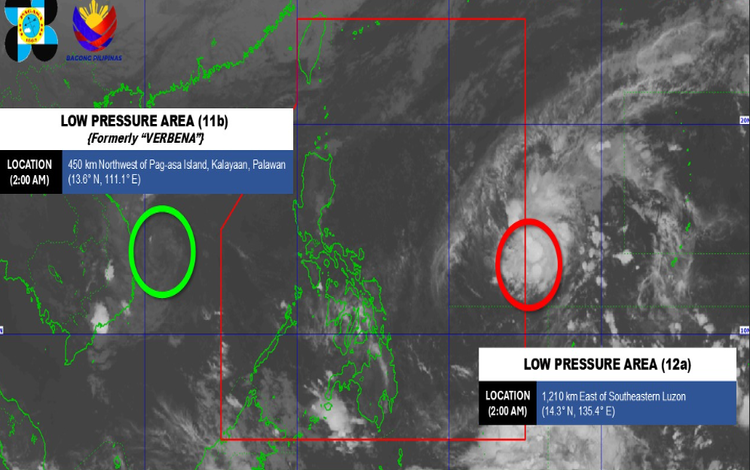
Low-Pressure Areas Monitored Outside PAR
As of 2:00 AM, former tropical cyclone “KOTO” (VERBENA) has weakened into LPA 11b, still being observed outside the Philippine Area of Responsibility (PAR). While no direct impact is expected, PAGASA continues to monitor its movement.
Meanwhile, LPA 12a, also located outside PAR, is showing a high chance of developing into a tropical depression within 24 hours. Though far from the country, enhanced winds and rains may still influence local weather conditions in the coming days.
Fair Weather with Isolated Thunderstorms Elsewhere
Metro Manila and most of the country will have partly cloudy to cloudy skies with isolated rainshowers or thunderstorms, mainly due to localized convective activity. PAGASA cautions that severe thunderstorms may trigger sudden flash floods or landslides, especially in flood-prone and mountainous communities.
Wind and Sea Conditions
- Northern Luzon: Moderate to strong northeast to north winds will prevail, producing moderate to rough seas with wave heights reaching 2.5 to 4.0 meters. Small vessels are advised to take precautions.
- Rest of Luzon: Winds will be light to moderate, with slight to moderate coastal waters.
- Visayas and Mindanao: Light to moderate north to northwest winds will result in slight to moderate seas.
Flood Advisories
PAGASA also issued General Flood Advisories (GFA #4 Final) for:
- Region 11 (Davao Region)
- Region 12 (SOCCSKSARGEN)
- Region 13 (CARAGA)
All advisories indicate flood conditions have subsided, but monitoring continues.