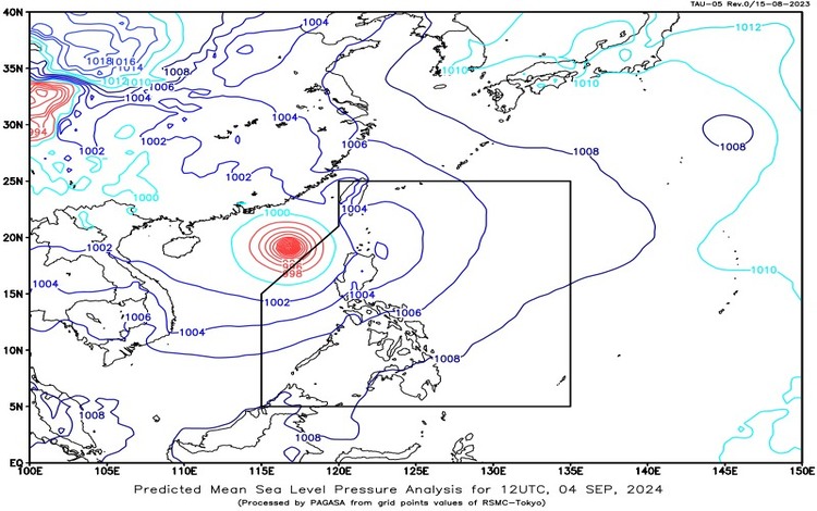
September 5, 2024, the Philippine Atmospheric, Geophysical, and Astronomical Services Administration (PAGASA) continues to monitor Typhoon Yagi (formerly “Enteng”), located 480 kilometers west-northwest of Laoag City, Ilocos Norte. The typhoon remains outside the Philippine Area of Responsibility (PAR), with maximum sustained winds of 175 kilometers per hour (km/h) and gusts reaching up to 215 km/h, moving westward at 25 km/h.

Synopsis
The trough of Typhoon Yagi is currently affecting the western section of Northern Luzon, while the Southwest Monsoon (Habagat) continues to influence weather conditions over Central and Southern Luzon.
Tropical Cyclone and Weather Conditions
Typhoon Yagi (formerly “Enteng”)
- Location: 480 km west-northwest of Laoag City, Ilocos Norte (19.1°N, 116.1°E)
- Maximum Sustained Winds: 175 km/h
- Gustiness: Up to 215 km/h
- Movement: Westward at 25 km/h
Forecast Weather Conditions
Cordillera Administrative Region, Ilocos Norte, and Ilocos Sur
- Weather Condition: Cloudy skies with scattered rain showers and thunderstorms.
- Cause: Trough of Typhoon Yagi.
- Potential Impacts: Possible flash floods or landslides due to moderate to heavy rains.
Pangasinan, Zambales, Bataan, and Occidental Mindoro
- Weather Condition: Monsoon rains.
- Cause: Southwest Monsoon.
- Potential Impacts: Possible flooding or landslides due to heavy to intense rains.
Metro Manila, La Union, Cavite, Batangas, Rizal, Laguna, Oriental Mindoro, Northern Palawan, and the rest of Central Luzon
- Weather Condition: Occasional rains.
- Cause: Southwest Monsoon.
- Potential Impacts: Possible flash floods or landslides due to moderate to heavy rains.
Quezon, Marinduque, and Romblon
- Weather Condition: Cloudy skies with scattered rain showers and thunderstorms.
- Cause: Southwest Monsoon.
- Potential Impacts: Possible flash floods or landslides due to moderate to at times heavy rains.
The Rest of the Country
- Weather Condition: Partly cloudy to cloudy skies with isolated rain showers or thunderstorms.
- Cause: Localized thunderstorms.
- Potential Impacts: Flash floods or landslides are possible during severe thunderstorms.
Wind and Coastal Water Conditions
- Western Section of Luzon
- Wind Speed: Strong
- Wind Direction: Southwest to South
- Coastal Waters: Rough, with waves reaching 2.8 to 4.5 meters.
- Rest of Luzon
- Wind Speed: Moderate to Strong
- Wind Direction: Southwest to Southeast
- Coastal Waters: Moderate to Rough, with waves between 2.1 to 4.0 meters.
- Visayas and Mindanao
- Wind Speed: Light to Moderate
- Wind Direction: South to Southwest
- Coastal Waters: Slight to Moderate, with waves between 0.6 to 2.5 meters.
Heavy Rainfall Warning (5:00 AM, September 5, 2024)
PAGASA has issued Heavy Rainfall Warning No. 28 for the National Capital Region and surrounding areas:
- Orange Warning Level: Zambales and Bataan
- Hazard: Flooding is still threatening in low-lying areas.
- Yellow Warning Level: Tarlac, Pampanga, Bulacan, Metro Manila, Rizal, and Cavite
- Hazard: Flooding is possible, especially in flood-prone areas.
Additionally, light to moderate rains, with occasional heavy downpours, are affecting Quezon, Laguna, Batangas, and Nueva Ecija, and may persist for the next three hours.
Palawan and Occidental Mindoro are expected to experience monsoon rains due to the Southwest Monsoon, while Northern Palawan will have occasional rains. The rest of Visayas and Palawan, including the Kalayaan Islands, will have partly cloudy to cloudy skies with isolated rain showers or thunderstorms, mainly caused by localized thunderstorms. Winds in these areas will vary from moderate to strong, with sea conditions ranging from moderate to rough. Meanwhile, Visayas will experience light to moderate winds and slight to moderate seas.
Residents are advised to stay updated on weather advisories and take necessary precautions, particularly in areas prone to flooding and landslides.
And due to the continued effects of bad weather, some areas have already declared #WalangPasok.
