The Southwest Monsoon continues to affect Southern Luzon, Visayas, and Mindanao, bringing widespread rains and thunderstorms across these regions. Meanwhile, the trough of Severe Tropical Storm Bebinca is influencing weather conditions in the rest of Luzon.
Severe Tropical Storm Bebinca (2413)
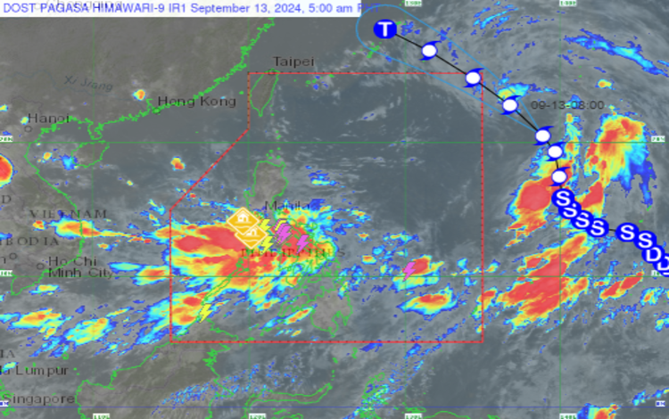
Severe Tropical Storm Bebinca, located 1,605 km east of Extreme Northern Luzon at coordinates 21.1°N, 137.3°E, has sustained winds of 95 km/h with gusts of up to 115 km/h. The storm is moving northwestward at a speed of 25 km/h. Currently outside the Philippine Area of Responsibility (PAR), Bebinca is expected to continue its path toward Northern Luzon, possibly intensifying in the coming days.
Forecast Weather Conditions
The following areas are expected to experience significant weather impacts due to the prevailing Southwest Monsoon and the influence of Severe Tropical Storm Bebinca:
- MIMAROPA, Western Visayas, and Negros Occidental
- Weather: Monsoon rains caused by the Southwest Monsoon.
- Impacts: Heavy to intense rains may lead to flash floods and landslides, particularly in low-lying and mountainous areas.
- Bicol Region, Southern Quezon, Batangas, and the rest of Visayas
- Weather: Cloudy skies with scattered to widespread rains and thunderstorms due to the Southwest Monsoon.
- Impacts: Moderate to heavy rains could cause flash floods and landslides in vulnerable areas.
- Mindanao
- Weather: Cloudy skies with scattered rains and thunderstorms due to the Southwest Monsoon.
- Impacts: The risk of flash floods and landslides remains high in areas experiencing moderate to heavy rainfall.
- Metro Manila and the rest of Luzon
- Weather: Cloudy skies with scattered rains and thunderstorms influenced by the trough of Severe Tropical Storm Bebinca.
- Impacts: Residents should remain vigilant for possible flash floods and landslides as rain intensity may vary between moderate to heavy at times.
Coastal Water Conditions
- Eastern Visayas and Mindanao: Expect strong winds from the southwest, leading to rough seas with wave heights ranging from 2.8 to 3.7 meters. Fisherfolk and small seacrafts are advised to avoid venturing into these waters.
- Palawan and the rest of Visayas and Mindanao: Winds will be moderate to strong, with moderate to rough seas (1.2 to 2.8 meters).
- The rest of Luzon: Winds are forecast to be light to moderate, with slight to moderate coastal waters (0.6 to 2.5 meters).
Heavy Rainfall Warnings
Pagasa has issued the following warnings for potential flooding and landslides in affected regions:
- Yellow Warning Level:
- Quezon: Light to moderate rains are expected, with flooding possibly occurring in flood-prone areas.
- Rizal, Batangas, and Metro Manila: Light to moderate rains with occasional heavy downpours within the next 3 hours.
- Heavy Rainfall Warning No. 4:
- Sorsogon: Red Warning due to severe flooding in flood-prone areas and increased risk of landslides in high-risk zones.
- Albay: Orange Warning as flooding is threatening low-lying areas and river channels, with landslides likely in steep terrain.
- Catanduanes and Camarines Norte: Yellow Warning due to possible flooding in low-lying areas.
5:00 AM Update
- Palawan, Kalayaan Islands, Occidental Mindoro, Western Visayas, and Negros Occidental: Monsoon rains due to the Southwest Monsoon will continue.
- The rest of Visayas: Cloudy skies with scattered rains and thunderstorms are expected, potentially causing further disruption.
Residents are urged to remain alert for updates and warnings from Pagasa, as conditions may rapidly change due to the influence of Severe Tropical Storm Bebinca and the ongoing Southwest Monsoon. Due to the adverse effects of Tropical Storm Bebinca and the southwest monsoon, some areas have declared class suspensions for today.