The Philippine Atmospheric, Geophysical and Astronomical Services Administration (PAGASA) reported that Tropical Storm Kristine (international name: Typhoon Kristine) has slightly intensified as it continues to move over the Philippine Sea, east of the Bicol Region. According to the 5:00 p.m. tropical cyclone bulletin released on Tuesday, October 22, the center of the storm was located approximately 390 kilometers east of Daet, Camarines Norte.
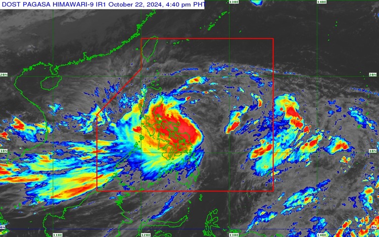
Typhoon Kristine is packing maximum sustained winds of 75 kilometers per hour (km/h) near the center, with gusts reaching up to 90 km/h. The storm is moving in a west-northwest direction at a speed of 15 km/h.
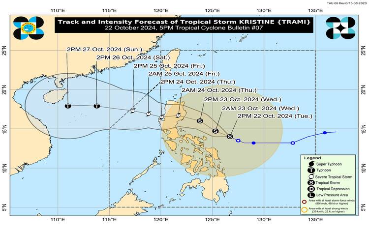
PAGASA forecasts that Typhoon Kristine will further strengthen and reach the severe tropical storm category before making landfall. Based on the latest track and intensity outlook, it is expected to hit land in the provinces of Isabela or northern Aurora by Wednesday night or early Thursday morning.
Once Typhoon Kristine makes landfall, it is predicted to slightly weaken as it traverses Northern Luzon. However, despite this slight weakening, the storm is expected to bring significant rainfall and gusty winds to affected areas. As it crosses Northern Luzon, heavy rainfall may result in possible flooding, landslides, and storm surges in coastal areas.
PAGASA also warned that Kristine will exit the landmass by Thursday afternoon or evening, heading toward the West Philippine Sea, specifically west of the Ilocos Region. The public is advised to stay vigilant and monitor updates as the storm could still cause severe weather conditions across parts of Luzon.
Residents in the affected areas, especially those in Northern Luzon and along the eastern seaboard of Luzon, are urged to take necessary precautions. Local government units have been advised to prepare for possible evacuations, particularly in low-lying and flood-prone areas. Fisherfolk are also cautioned against venturing out to sea due to rough conditions.
PAGASA continues to monitor the storm’s movement closely and will provide updated bulletins to keep the public informed. The next advisory is expected by 11:00 p.m. tonight.