Tropical Depression Gener remains steady, hovering over the waters east of Cagayan Valley. According to the latest data from the Philippine Atmospheric, Geophysical, and Astronomical Services Administration (PAGASA), Gener was located approximately 305 kilometers east-northeast of Casiguran, Aurora, or about 325 kilometers east of Tuguegarao City, Cagayan. The storm is currently moving north-northwestward at a speed of 10 km/h.
Intensity and Winds
Gener is sustaining maximum winds of 55 kilometers per hour (km/h) near its center, with gusts reaching up to 70 km/h. Its central pressure is measured at 996 hPa. The extent of the tropical cyclone’s winds stretches up to 360 kilometers outward from its center, affecting a significant area.
Tropical Cyclone Wind Signals (TCWS)
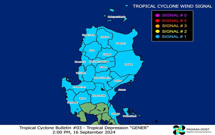
PAGASA has raised Tropical Cyclone Wind Signal No. 1 over multiple areas in Luzon. Under this wind signal, strong winds ranging from 39 to 61 km/h are expected within the next 36 hours. Areas under this signal should expect minimal to minor threats to life and property due to the winds.
The following areas are currently under TCWS No. 1:
- Cagayan, including Babuyan Islands
- Isabela, Quirino, Nueva Vizcaya
- Apayao, Kalinga, Abra
- Ifugao, Mountain Province, Benguet
- Ilocos Norte, Ilocos Sur, La Union, Pangasinan
- Zambales, Tarlac, Nueva Ecija, Aurora
- The northern portion of Quezon (General Nakar, Infanta, Real), including Polillo Islands
Hazards Affecting Land Areas
Heavy Rainfall Outlook
Tropical Depression Gener, in conjunction with the Southwest Monsoon and Tropical Storm Pulasan, is expected to bring heavy rainfall across parts of Luzon and Visayas. PAGASA has issued Weather Advisory No. 20 at 2:00 PM today to outline the expected precipitation. Flooding and landslides in flood-prone and mountainous areas remain a potential hazard.
Severe Winds
Strong winds will continue to affect areas under TCWS No. 1. In coastal and mountainous regions, the winds may be stronger due to enhanced local conditions. However, impacts from these winds are expected to be minimal to minor.
Gener, along with the monsoon and Tropical Storm Pulasan, will also bring strong to gale-force winds over Batanes, MIMAROPA, Bicol Region, Visayas, and parts of Mindanao today and tomorrow. On Wednesday (September 18), areas such as Metro Manila, CALABARZON, and Bulacan may also experience gusty winds.
Hazards Affecting Coastal Waters
PAGASA has issued a Gale Warning over several seaboards in Southern Luzon, Visayas, and Mindanao. Small seacrafts are advised against sea travel due to dangerous conditions. Moderate to rough seas, with wave heights ranging from 1.5 to 3.5 meters, are expected around Batanes, Babuyan Islands, and the northern coastlines of the Ilocos Region and Cagayan Valley.
Seafarers should exercise caution, particularly in areas where sea conditions are rough or where Gale Warnings are in place.
Track and Intensity Outlook
Tropical Depression Gener is forecast to make landfall in the vicinity of Isabela or Aurora within the next 24 hours. Afterward, the system is expected to emerge over the coastal waters of La Union or Pangasinan by tomorrow morning (September 17). Gener will then move west-southwestward over the West Philippine Sea and exit the Philippine Area of Responsibility (PAR) between tomorrow evening and Wednesday morning (September 18). After exiting PAR, the system will likely make landfall over southern mainland China by Friday (September 20).
There is a possibility that Gener may strengthen into a tropical storm as it crosses the West Philippine Sea, but for now, it remains categorized as a tropical depression. PAGASA will continue to monitor its development and issue updates accordingly.
Residents in the affected areas are advised to stay alert and follow updates from authorities, especially concerning possible floods, landslides, and strong winds.