As of the 5:00 PM advisory issued by the Philippine Atmospheric, Geophysical and Astronomical Services Administration (PAGASA) on September 16, 2024, Tropical Depression “Gener” continues its steady approach toward Northern Luzon, bringing with it potentially hazardous weather conditions. Gener, the seventh tropical cyclone to enter the Philippine Area of Responsibility (PAR) this year, is anticipated to make landfall either tonight or early tomorrow morning.
Current Status of Tropical Depression Gener
As of 4:00 PM, the center of Tropical Depression Gener was located approximately 290 kilometers east of Tuguegarao City, Cagayan, at coordinates 17.4°N and 124.5°E. The depression is moving northwestward at a speed of 10 kilometers per hour (km/h). Gener currently packs maximum sustained winds of 55 km/h near its center, with gustiness reaching up to 70 km/h. The storm’s central pressure is measured at 996 hPa.
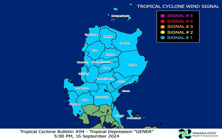
Tropical Cyclone Wind Signals (TCWS)
PAGASA has raised Tropical Cyclone Wind Signal No. 1 over several provinces in Luzon. The affected areas include Cagayan, the Babuyan Islands, Isabela, Quirino, Nueva Vizcaya, Apayao, Kalinga, Abra, Ifugao, Mountain Province, Benguet, Ilocos Norte, Ilocos Sur, La Union, Pangasinan, Zambales, Tarlac, Nueva Ecija, Aurora, and the northern portion of Quezon, including the Polillo Islands. Residents in these areas are advised to prepare for strong winds with speeds ranging from 39 to 61 km/h, which may bring minimal to minor threats to life and property. The public is urged to stay informed and adhere to local government advisories.
Heavy Rainfall and Winds
The heavy rainfall outlook for areas impacted by Gener can be found in PAGASA’s Weather Advisory No. 21, also issued at 5:00 PM today. In addition to the heavy rain directly associated with Gener, the tropical depression is enhancing the Southwest Monsoon, which is also being intensified by Tropical Storm Pulasan. This interaction will bring strong gale-force gusts over the areas of Batanes, MIMAROPA, the Bicol Region, Visayas, Zamboanga Peninsula, Northern Mindanao, and the Caraga and Davao regions today. Tomorrow (September 17), the monsoon will continue to impact Batanes, MIMAROPA, Bicol Region, Visayas, and Mindanao, and by Wednesday (September 18), its effects will extend to Zambales, Bataan, Pampanga, Bulacan, Metro Manila, CALABARZON, and more regions in the Visayas and Mindanao.
Sea Conditions and Gale Warnings
Mariners are advised to exercise caution, as gale warnings are in effect for several coastal waters. Sea travel remains dangerous for small vessels, especially motorbancas, in regions experiencing rough seas. Waves reaching 1.5 to 3.5 meters are expected in the coastal waters of Batanes, Babuyan Islands, and the northern seaboards of Ilocos and Cagayan Valley. Similarly, rough seas will affect the eastern seaboard of the Bicol Region, Visayas, and Mindanao. PAGASA has advised inexperienced mariners and operators of poorly equipped boats to avoid venturing out to sea.
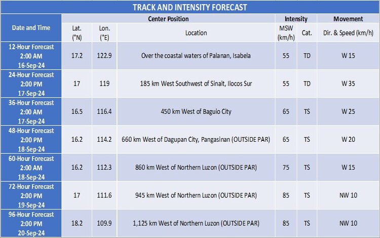
Forecast Track and Intensity
Tropical Depression Gener is projected to make landfall either late tonight or early tomorrow morning in the vicinity of Isabela or Aurora. After crossing Luzon, it is forecast to emerge over the coastal waters of La Union or Pangasinan tomorrow before moving westward over the West Philippine Sea. Gener is likely to exit the PAR between late tomorrow and Wednesday morning. While it is expected to maintain tropical depression status while crossing Luzon, there is a possibility of it intensifying into a tropical storm once it moves over the sea.
PAGASA will continue to monitor Tropical Depression Gener and issue updates as the situation evolves.