The Low-Pressure Area (LPA) east of Aurora has intensified into Tropical Depression “Gener.” The latest data from weather authorities reveals several key details about the developing storm.
Location and Movement
The center of Tropical Depression Gener was estimated at 315 kilometers east-northeast of Casiguran, Aurora, located at coordinates 16.9°N, 125.0°E. The storm is moving west-northwestward at a speed of 10 kilometers per hour.
Intensity
Gener has maximum sustained winds of 45 km/h near its center, with gusts reaching up to 55 km/h. The storm’s central pressure stands at 998 hPa. The strong winds from Gener extend up to 360 kilometers from its center, significantly impacting a wide area.
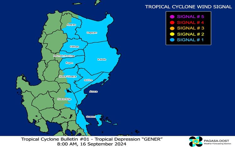
Tropical Cyclone Wind Signals
At present, Tropical Cyclone Wind Signal No. 1 is in effect for several regions in Luzon. This warning indicates strong winds with speeds ranging from 39 to 61 km/h and a lead time of 36 hours. Areas under this signal can expect minimal to minor impacts on life and property due to the winds. The affected areas include:
- Eastern and central portions of Mainland Cagayan, including cities and towns like Tuguegarao City and Aparri.
- Isabela, Quirino, and parts of Nueva Vizcaya.
- Eastern and southern Apayao, Kalinga, and portions of Mountain Province.
- Parts of Ifugao, Aurora, Nueva Ecija, and northern Mainland Quezon, including Polillo Islands.
Other Hazards Affecting Land Areas
Heavy Rainfall Outlook: The Southwest Monsoon, enhanced by Gener and Tropical Storm “Pulasan,” is expected to bring heavy rainfall. The public should refer to Weather Advisory No. 18 for detailed information on expected rainfall.
Severe Winds: Local winds may be stronger in coastal and upland/mountainous areas exposed to Gener’s influence. Minimal to minor impacts are anticipated in areas under Wind Signal No. 1.
Southwest Monsoon Impact: Gener, along with Pulasan, is expected to bring strong to gale-force gusts over MIMAROPA, the Bicol Region, Visayas, Zamboanga Peninsula, Northern Mindanao, Caraga, and Davao Region. The gusts are likely to affect these areas today and tomorrow, continuing through Wednesday.
Hazards Affecting Coastal Waters
A Gale Warning is in effect for several regions. Sea travel is risky for small seacrafts and all types of motorbancas. Gale Warning No. 4, issued at 5:00 AM, highlights the following sea conditions:
- Moderate to Rough Seas: 1.5 to 3.5 meters, affecting Northern Luzon, Central Luzon, and eastern Southern Luzon. Mariners are advised to avoid venturing out to sea under these conditions.
- Up to Moderate Seas: 1.5 to 2.5 meters, covering the remaining coastal areas not under Gale Warning. Mariners should take precautions and avoid navigation where possible.
Track and Intensity Outlook
Gener is forecast to continue moving west to west-southwest until Wednesday afternoon. It is expected to turn west-northwestward to northwestward thereafter. Landfall is anticipated in Isabela or Aurora within the next 24 hours. Gener might exit the Philippine Area of Responsibility (PAR) by Wednesday and is forecast to impact Hainan, China, by late Friday to early Saturday.
Gener is likely to see limited intensification over the next two days but may reach Tropical Storm strength by Wednesday after emerging over the West Philippine Sea. The storm is expected to maintain Tropical Storm intensity before weakening to a Tropical Depression before its landfall in Hainan, China. Changes in intensity and track are likely as Gener crosses Luzon.
For the latest updates and advisories, residents are encouraged to stay tuned to local weather stations and authorities.