The Philippine Atmospheric, Geophysical and Astronomical Services Administration (PAGASA) released its latest advisory at 8:00 PM on Friday, August 22, 2025, reporting that Tropical Depression Isang continues to move west-northwestward and is now situated over Ifugao Province. The weather system is forecast to cross Northern Luzon overnight before emerging over the West Philippine Sea by Saturday.
Location and Intensity
As of 7:00 PM, the center of Isang was estimated in the vicinity of Lagawe, Ifugao (16.8°N, 121.2°E), based on all available data, including those from the Benguet Doppler Weather Radar. The tropical depression is carrying maximum sustained winds of 55 kilometers per hour near the center, with gusts reaching up to 90 km/h. Its central pressure is measured at 1002 hPa, and it is moving west-northwestward at 15 km/h.
Strong winds extend outward up to 150 kilometers from its center, posing minimal to minor threats to life and property, especially in exposed areas.
Tropical Cyclone Wind Signals in Effect
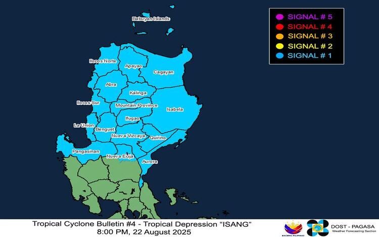
PAGASA has placed several areas under Tropical Cyclone Wind Signal (TCWS) No. 1, indicating strong winds within 36 hours. These areas include:
- Cagayan, Isabela, Quirino, Nueva Vizcaya, Apayao, Kalinga, Abra, Mountain Province, Ifugao, Benguet, Ilocos Norte, Ilocos Sur, La Union, Pangasinan, Aurora, and the northern portion of Nueva Ecija (Lupao, Carranglan, Pantabangan, San Jose City).
Winds in these locations may range from 39 to 61 km/h, bringing slight damage to light structures, particularly in coastal and upland zones.
Rainfall and Wind Hazards
In addition to Isang’s winds, the tropical depression is enhancing the Southwest Monsoon, which will bring gusty conditions and intermittent heavy rains across several regions.
- August 22: Zambales, Bataan, Metro Manila, CALABARZON, MIMAROPA, Bicol Region, Western Visayas, Central Visayas, and parts of Mindanao, including Dinagat Islands, Surigao del Norte, Camiguin, and Southern Leyte.
- August 23: Batanes, Cagayan, Ilocos Region, CAR, Central Luzon, Metro Manila, and portions of Southern Luzon.
- August 24: Kalayaan Islands.
PAGASA warned residents in flood- and landslide-prone areas to remain alert and monitor advisories closely.
Coastal Conditions
Although no gale warning is currently raised, rough seas up to 3.0 meters are expected along the seaboards of Batanes and Cagayan, while moderate seas up to 2.5 meters may affect Isabela, Ilocos Norte, and Ilocos Sur. Mariners of small sea vessels are strongly advised to avoid venturing out under these conditions due to possible risks.
Track and Forecast
Isang is expected to leave the Philippine Area of Responsibility (PAR) by Saturday morning or afternoon. It is also forecast to strengthen into a tropical storm within 24 hours and may reach severe tropical storm category while moving over the waters south of Hainan, China.
Communities across Northern and Central Luzon are urged to take necessary precautions against potential floods, landslides, and hazardous sea conditions, while continuously monitoring official weather updates.