Tropical Storm “ENTENG” has further intensified and is rapidly approaching the coastal waters of Casiguran, Aurora. The storm is expected to make landfall over the northern Aurora-southeastern Isabela area within the next three hours, bringing with it strong winds, heavy rainfall, and potential hazards to affected regions.
Current Location and Intensity
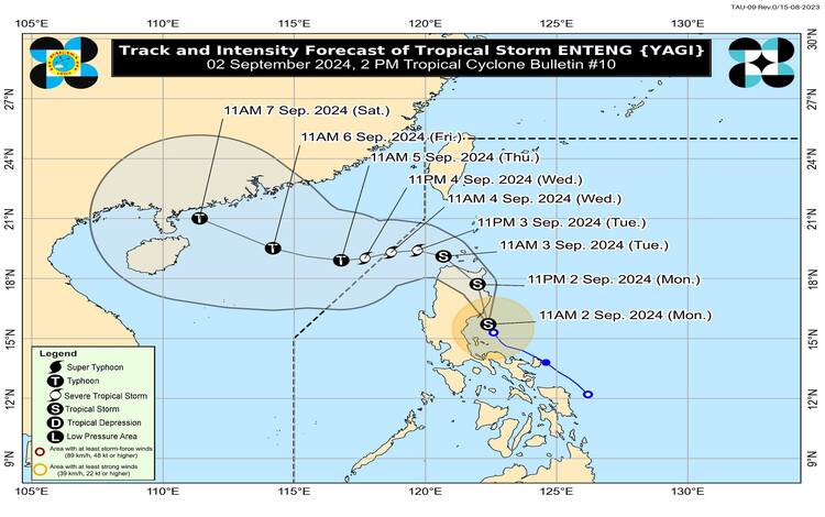
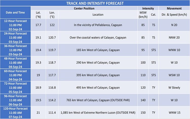
The center of Tropical Storm “ENTENG” was last estimated based on all available data, including the Baler Weather Radar, to be at 16.3°N, 122.3°E, just off the coast of Casiguran, Aurora. The storm has sustained winds of 85 km/h near its center, with gusts reaching up to 105 km/h. Its central pressure is measured at 990 hPa. Moving north-northwestward at a speed of 20 km/h, “ENTENG” is on a direct path to impact northern Aurora and southeastern Isabela.
Tropical Cyclone Wind Signals (TCWS)
TCWS No. 2 has been raised in several areas, indicating gale-force winds with speeds ranging from 62 to 88 km/h. The affected regions under this signal include:
- Ilocos Norte
- Apayao
- Eastern portions of Kalinga
- Cagayan, including Babuyan Islands
- Isabela
- Quirino
- The northern portion of Aurora
- Polillo Islands
- The northern portion of Camarines Norte
These areas should expect minor to moderate threats to life and property due to the strong winds.
TCWS No. 1 is also in effect for regions expected to experience strong winds with speeds of 39 to 61 km/h. This signal covers a broader area including Batanes, Ilocos Sur, La Union, Metro Manila, and other parts of Luzon.
Heavy Rainfall and Severe Winds
“ENTENG” is forecast to bring heavy rainfall to northern Quezon, Aurora, Isabela, Cagayan, Zambales, and parts of Pangasinan from today until tomorrow afternoon, with accumulated rainfall ranging from 100 to 200 mm. The storm is also expected to enhance the Southwest Monsoon, leading to moderate to intense rainfall in other parts of Luzon and Visayas over the next three days.
Strong to gale-force winds are anticipated across many regions, particularly in coastal and upland areas, with the highest Wind Signal potentially reaching No. 3 during “ENTENG’s” passage.
Track and Intensity Outlook
“ENTENG” is forecast to maintain its tropical storm status as it moves across Northern Luzon, with further intensification expected by tomorrow evening, potentially reaching severe tropical storm or even typhoon category by Thursday. The storm is likely to exit the Philippine Area of Responsibility by Wednesday afternoon.
Residents in affected areas are advised to prepare for the impending landfall and to follow the guidance of local authorities for any necessary evacuations or safety measures.