As of 5:00 PM on September 2, 2024, Tropical Storm Enteng (international name: Yagi) has made landfall in Casiguran, Aurora, and is currently situated over Quirino Province. The center of the storm was last located in the vicinity of Maddela, Quirino (16.3°N, 122.3°E), with maximum sustained winds of 85 km/h and gustiness reaching up to 140 km/h. Enteng is moving north-northwestward at 20 km/h, with strong to gale-force winds extending up to 200 km from its center.
Tropical Cyclone Wind Signals (TCWS) in Effect
- TCWS No. 2 has been hoisted over several areas in Luzon, including Ilocos Norte, Apayao, Cagayan, Isabela, Quirino, and parts of Kalinga and Aurora. Winds ranging from 62 to 88 km/h are expected, posing a minor to moderate threat to life and property.
- TCWS No. 1 is in effect over Batanes, Ilocos Sur, La Union, parts of Pangasinan, and other areas in Central Luzon and Metro Manila, where wind speeds of 39 to 61 km/h could result in minimal to minor damage.
Heavy Rainfall and Flooding Risks
The storm is forecast to bring significant rainfall over various parts of Luzon. From today until tomorrow afternoon, the Ilocos Region, Nueva Vizcaya, Quirino, Isabela, and parts of Aurora could receive 100-200 mm of rain, while Metro Manila and other regions may experience 50-100 mm. The heavy rainfall, especially in elevated areas, could lead to flooding and landslides in susceptible areas.
Enhanced Southwest Monsoon
The Southwest Monsoon, enhanced by Enteng, will bring moderate to intense rainfall over Luzon and parts of Visayas in the next three days. The regions most affected today include Ilocos, Zambales, Bataan, and Metro Manila, with the potential for strong winds and localized flooding.
Coastal Hazards
A minimal to moderate risk of storm surge is expected along the coasts of Batanes, Cagayan, Isabela, Ilocos Norte, Ilocos Sur, and Aurora within the next 48 hours. Additionally, gale warnings are in effect for the northern and eastern seaboards of Luzon, making sea travel risky for small vessels.
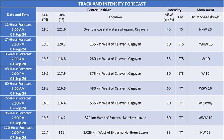
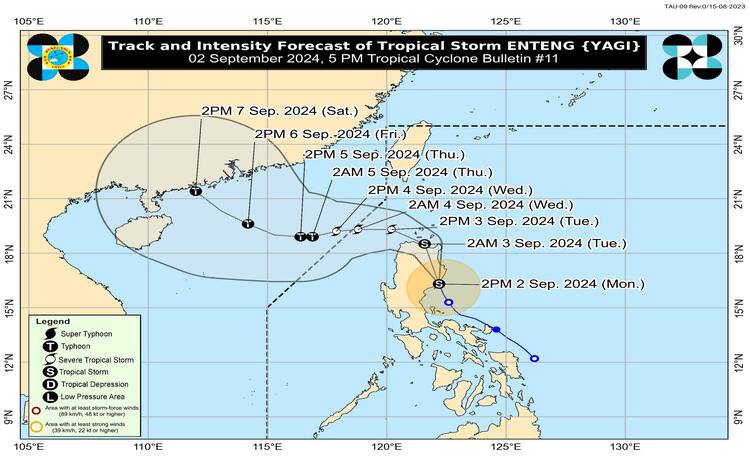
Track and Intensity Outlook
Enteng is forecast to continue its north-northwestward movement over Northern Luzon before turning west-northwestward over the Babuyan Channel by tomorrow morning. The storm is expected to intensify further, potentially reaching typhoon category by Thursday as it moves over the West Philippine Sea. Enteng may exit the Philippine Area of Responsibility by Wednesday morning or afternoon.
Residents in affected areas are advised to stay updated with the latest weather bulletins and take necessary precautions, especially those in areas prone to flooding and landslides.