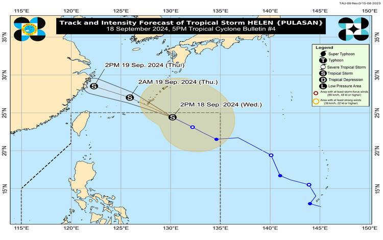
As of 5:00 PM on September 18, 2024, Tropical Storm Helen, internationally named PULASAN, is on the verge of leaving the Philippine Area of Responsibility (PAR). The center of Helen was last located approximately 930 km east-northeast of extreme northern Luzon, at coordinates 24.6°N, 129.9°E. The storm continues to maintain maximum sustained winds of 85 km/h near the center, with gusts reaching up to 105 km/h and a central pressure of 994 hPa. Moving northwestward at 40 km/h, Helen is expected to exit PAR within the next three hours.
Though Helen poses no direct threat to the Philippine mainland, its wide wind field extends up to 650 km from the center, producing strong to gale-force winds. No Tropical Cyclone Wind Signals (TCWS) are currently in effect, but indirect effects, particularly from the enhanced southwest monsoon (habagat), are expected.
Enhanced Southwest Monsoon Effects
The combination of Helen and another weather disturbance, Tropical Storm Gener, is enhancing the southwest monsoon, leading to widespread strong gale-force gusts in several areas. For today, gusty winds are anticipated in Zambales, Bataan, Pampanga, Bulacan, Metro Manila, CALABARZON, MIMAROPA, the Bicol Region, Visayas, and parts of Mindanao, including Zamboanga Peninsula, Northern Mindanao, Caraga, and Davao Region.
Tomorrow, September 19, stronger winds will persist in Ilocos Region, Isabela, Aurora, and many of the same areas affected today, while by Friday, September 20, the winds will extend to Batanes, Abra, Benguet, and other parts of northern Luzon.
Coastal Hazards and Gale Warnings
A Gale Warning is in effect for coastal waters across the western seaboard of Central Luzon, Occidental Mindoro, and Palawan, including the Kalayaan Islands. Sea travel is hazardous in these regions, particularly for small vessels. Mariners are advised to avoid venturing out to sea under these conditions due to the risk posed by rough to very rough seas.
Beyond the Gale Warning areas, seas remain moderately rough, with waves between 1.5 to 3.5 meters affecting the seaboards of northern Luzon and parts of the Visayas and Mindanao. Mariners, especially those operating small vessels, should remain cautious and avoid risky voyages.
Forecast and Outlook
Helen is expected to remain a tropical storm as it tracks northwestward over the East China Sea. It is forecast to gradually weaken without significantly impacting the Philippine mainland. The public is advised to stay updated on any further developments, particularly on the impacts of the enhanced monsoon.