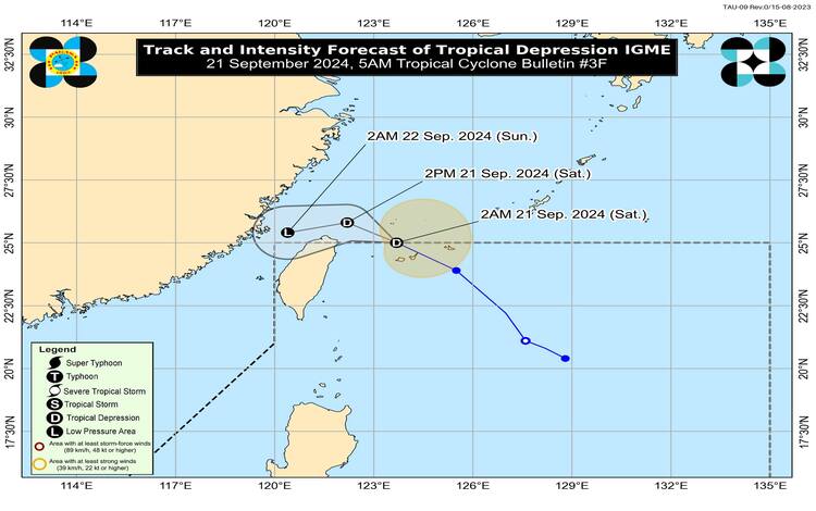
Tropical Depression Igme has exited the Philippine Area of Responsibility (PAR) as of today, September 21, 2024. At 4:00 AM, the center of Igme was located approximately 520 kilometers north-northeast of Itbayat, Batanes, at coordinates 25.2°N and 123.5°E. With maximum sustained winds of 55 kilometers per hour near its center and gustiness reaching up to 70 kilometers per hour, the tropical depression continues to move northwestward at 35 kilometers per hour. Its central pressure is measured at 1002 hPa, and the storm’s strong winds extend outward up to 240 kilometers from its center.

Despite Igme moving out of the PAR, it continues to enhance the southwest monsoon, bringing adverse weather conditions to parts of Luzon. The Philippine Atmospheric, Geophysical, and Astronomical Services Administration (PAGASA) issued advisories regarding the impact of the southwest monsoon, particularly on wind gusts and rainfall in various regions of the country.
Wind Conditions and Rainfall Outlook
As of the latest bulletin, no tropical cyclone wind signals (TCWS) are currently hoisted across any part of the Philippines. However, the enhanced southwest monsoon continues to pose hazards, particularly in coastal and upland areas prone to strong winds.
- For today (September 21, 2024), regions such as the Ilocos Region, Abra, Benguet, Batanes, Babuyan Islands, the extreme eastern portion of Isabela, Nueva Vizcaya, and Zambales are expected to experience strong to gale-force gusts.
- For tomorrow (September 22, 2024), these gusty conditions will persist over the Ilocos Region, Abra, Benguet, Batanes, Babuyan Islands, mainland Cagayan, Isabela, Nueva Vizcaya, and Zambales.
PAGASA advises residents in these areas to remain vigilant against the possibility of severe wind impacts, particularly in exposed coastal and upland locations. Meanwhile, heavy rainfall is expected to accompany the enhanced monsoon, which may cause localized flooding and landslides. The detailed rainfall outlook is available in PAGASA’s Weather Advisory No. 43 issued at 5:00 AM today.
Coastal Hazards and Sea Conditions
A Gale Warning is in effect for the western seaboard of the Ilocos Region, indicating hazardous sea conditions. Small seacrafts, particularly motorbancas, are strongly advised against venturing out to sea due to risky travel conditions. PAGASA reported sea conditions as follows:
- Rough seas (waves between 2.5 to 4.0 meters) are expected along the seaboards of Batanes and Zambales.
- Moderate to rough seas (1.5 to 3.5 meters) are expected over the seaboards of Babuyan Islands, and 1.0 to 3.0 meters over Bataan, Kalayaan Islands, and mainland Cagayan.
- The coastal waters of Isabela and Lubang Island will experience moderate seas (1.0 to 2.5 meters).
Mariners are urged to exercise caution and avoid unnecessary sea travel, especially in areas where the sea is rough. Inexperienced operators or those navigating inadequately equipped vessels are at increased risk.
Track and Intensity Forecast
Igme is expected to track further northwestward today over the East China Sea while gradually slowing down. By tomorrow, September 22, 2024, the tropical depression is forecast to shift west-southwestward. The influence of a passing frontal system over the East China Sea will likely cause Igme to weaken into a low-pressure area.

General Flood Advisories
PAGASA also issued flood advisories this morning, with specific alerts for the following regions:
- Region 1 (Ilocos Region) – General Flood Advisory (GFA) #4
- Region 2 (Cagayan Valley) – GFA #4
- Region 3 (Central Luzon) – GFA #17
- Region 4A (CALABARZON) – GFA #17
- Region 4B (MIMAROPA) – GFA #19
- Region 8 (Eastern Visayas) – GFA #3
- Cordillera Administrative Region (CAR) – GFA #3
Residents in these areas are advised to monitor updates from local authorities and remain prepared for possible flood occurrences.
As Tropical Depression Igme moves away from the Philippines, its impacts will continue to be felt through the enhanced southwest monsoon. PAGASA will continue to issue updates as necessary to inform the public of any developments.
