At 5:00 AM on September 27, 2024, the Philippine Atmospheric, Geophysical, and Astronomical Services Administration (PAGASA) confirmed that the low-pressure area east of Batanes has developed into Tropical Depression “Julian,” becoming the country’s newest weather disturbance.
Location and Intensity
As of 4:00 AM today, the center of Tropical Depression Julian was located 525 kilometers east of Itbayat, Batanes, at 20.9°N latitude and 126.9°E longitude. The tropical depression is moving south-southwest at 15 km/h. Julian currently carries maximum sustained winds of 55 km/h near the center, with gusts reaching up to 70 km/h. The central pressure of the tropical depression is estimated at 1004 hPa. Tropical Depression Julian is expected to intensify as it moves, potentially developing into a tropical storm by tonight or tomorrow morning.
Tropical Cyclone Wind Signals
As of the latest advisory, no Tropical Cyclone Wind Signals (TCWS) have been raised. However, PAGASA has indicated that TCWS No. 1 could be hoisted later today over portions of the Cagayan Valley region as Julian’s path continues to shift.
In addition to this, it is predicted that Wind Signal No. 2 or 3 may be raised in certain areas over the coming days if Tropical Depression Julian continues to intensify as forecasted.
Heavy Rainfall and Severe Winds Outlook
While there are no wind signals yet, the tropical depression is expected to bring strong to gale-force gusts across several areas in Luzon and Visayas in the coming days. According to PAGASA, coastal and upland areas, particularly in Aurora, Quezon, and the Bicol Region, should be prepared for these strong winds beginning tomorrow, September 28. By Sunday, September 29, stronger winds will be felt across a wider region including Aurora, Bataan, Pampanga, Bulacan, Metro Manila, CALABARZON, Romblon, Marinduque, the Bicol Region, Western Visayas, Negros Occidental, and Northern Samar.
For further details on rainfall predictions, PAGASA advises referring to Weather Advisory No. 1 issued at 5:00 AM today, which covers the heavy rainfall outlook related to Tropical Depression Julian.
Coastal Waters and Sea Conditions
Seafarers and those residing near coastal areas should also take precautions. Over the next 24 hours, moderate sea conditions are expected along the seaboards of Batanes, Cagayan, and Isabela, with waves reaching up to 2.5 meters in height. PAGASA advises operators of small vessels, such as motorbancas, to avoid navigating these waters until conditions improve.
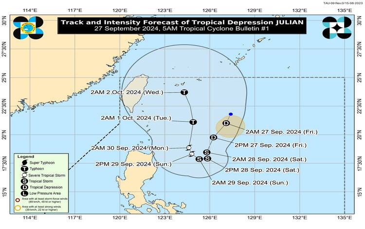
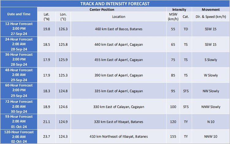
Track and Intensity Forecast
Tropical Depression Julian is projected to follow a looping path over the waters east of Batanes and Cagayan during the next five days. It will move south-southwest today, decelerating as it progresses. By tomorrow, Julian is expected to shift westward at a slow pace, before turning northwest on Sunday. The tropical depression is forecast to accelerate northward starting Monday, September 30, and continue through Tuesday, October 1.
Throughout this period, PAGASA predicts that Julian will gradually strengthen, reaching the tropical storm category by tonight or early tomorrow. Julian may evolve into a severe tropical storm on Sunday, and by Tuesday, October 1, it could intensify further into a typhoon.
Advisory and Public Preparedness
Residents in potentially affected areas, particularly in the Cagayan Valley, Bicol Region, and Visayas, are advised to stay updated on PAGASA’s bulletins. The next weather update on Tropical Depression Julian will be issued at 11:00 AM today.
PAGASA continues to monitor the tropical depression’s development and will issue necessary advisories regarding wind signals, rainfall, and sea conditions as the weather system evolves.