The Philippine Atmospheric, Geophysical, and Astronomical Services Administration (PAGASA) issued an update on Tropical Storm “Kristine” (international name: TRAMI), which has intensified into a tropical storm as of 5:00 AM today. This update is valid for broadcast until 11:00 AM.
Current Status
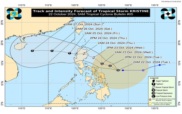
As of 4:00 AM, the center of Tropical Storm Kristine was located approximately 390 km east of Virac, Catanduanes (13.2°N, 127.8°E). It has maximum sustained winds of 65 km/h near the center and gustiness of up to 80 km/h, with a central pressure of 994 hPa. Kristine is currently moving westward at 15 km/h, and strong to gale-force winds extend up to 680 km from the storm’s center.
Tropical Cyclone Wind Signals (TCWS) in Effect
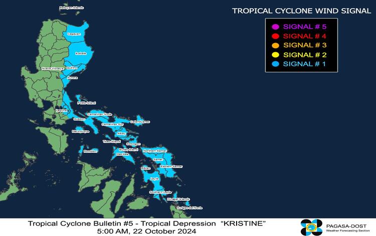
TCWS No. 1 has been raised over several areas, indicating the threat of strong winds within the next 36 hours. Winds ranging from 39 to 61 km/h (Beaufort Scale 6 to 7) are expected, posing minimal to minor threats to life and property.
Affected Areas:
- Luzon: Eastern and central portions of mainland Cagayan, Isabela, Quirino, the southern part of Nueva Vizcaya, Aurora, parts of Rizal and Laguna, northern and eastern portions of Quezon, Polillo Islands, Marinduque, Romblon, Camarines Norte, Camarines Sur, Catanduanes, Albay, Sorsogon, Masbate, Ticao Island, Burias Island.
- Visayas: Eastern Samar, Northern Samar, Samar, Leyte, Biliran, Southern Leyte.
- Mindanao: Dinagat Islands, Surigao del Norte including Siargao and Bucas Grande Group.
Wind and Rainfall Hazards
Kristine’s wind signals primarily indicate strong winds, which are expected to be slightly stronger in coastal and upland areas exposed to the winds. Areas under Wind Signal No. 1 may experience minimal to minor impacts. There is also the possibility of further intensification, potentially raising the wind signal to No. 4, as Kristine could rapidly intensify.
Additionally, the Northeasterly Windflow, combined with the storm, may bring gusty conditions to several areas, including:
- Today (22 October): Batanes, Babuyan Islands, Ilocos Region, Palawan, Romblon, Aklan, Antique, Negros Island Region, Central Visayas, Southern Leyte, Zamboanga del Norte, Northern Mindanao, Dinagat Islands, Surigao del Norte, Agusan del Norte, Sarangani, Davao del Sur, and Davao Oriental.
- Tomorrow (23 October): MIMAROPA, Visayas, and Mindanao.
- Thursday (24 October): MIMAROPA, Bicol Region, Visayas, Basilan, Sulu, Tawi-Tawi, Zamboanga del Norte, Lanao del Sur, Northern Mindanao, Dinagat Islands, Surigao del Norte, Davao del Sur, and Davao Oriental.
Sea Condition and Gale Warnings
A Gale Warning is in effect over the eastern seaboard of Luzon, the southern seaboard of Southern Luzon, and the eastern seaboard of Visayas. Very rough seas are expected, with waves reaching up to 6.5 meters over the seaboard of Isabela and the northern and eastern seaboard of the Bicol Region. Sea travel is highly risky for all types of vessels, and mariners are advised to remain in port or seek shelter.
Track and Intensity Outlook
Kristine is forecast to continue moving west-northwest until Thursday, October 24, before turning westward. On its current track, Kristine may land over Isabela on the evening of October 23. It is expected to exit the Philippine Area of Responsibility by Friday, October 25. While it is projected to remain a tropical storm over the next 24 hours, Kristine may strengthen into a severe storm upon landfall and eventually reach typhoon category as it emerges over the West Philippine Sea by Friday. Rapid intensification remains possible given the favorable conditions.
Further updates will be provided in the subsequent bulletins as Kristine’s path and intensity evolve.