Tropical Storm Enteng is on track to potentially make landfall over Cagayan and Isabela on Monday, according to the Philippine Atmospheric, Geophysical and Astronomical Services Administration (Pagasa). As of the 8:00 a.m. update, Enteng was located 100 kilometers north-northwest of Daet, Camarines Norte, moving west-northwest at 15 kilometers per hour (kph).
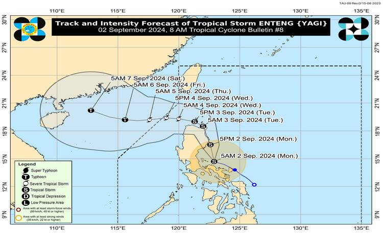
Enteng is currently packing maximum sustained winds of 75 kph and gusts of up to 90 kph. Pagasa’s forecast suggests that the storm could land in either Isabela or Cagayan later today or tonight. However, the possibility of a landfall over Aurora or the Babuyan Islands remains if the storm alters its current trajectory.
Given Enteng’s approach, Pagasa has raised Tropical Cyclone Wind Signal (TCWS) No. 2 in several areas across Luzon. This signal indicates that these regions can expect winds ranging from 62 kph to 88 kph within the next 24 hours. This level of wind strength can lead to minor to moderate impacts on life and property.
The areas under TCWS No. 2 include the northeastern portion of Camarines Norte, specifically the municipalities of Vinzons, San Lorenzo Ruiz, Talisay, Daet, Labo, Paracale, Jose Panganiban, San Vicente, Basud, Mercedes, Santa Elena, and Capalonga.
Residents in these areas are advised to take necessary precautions and stay updated on weather advisories as the storm’s path develops. Local authorities are also on high alert to provide assistance and ensure safety measures are in place to mitigate potential damage from the storm.