As of the latest update at 4:00 PM today, Tropical Depression Gener continues its westward movement over the West Philippine Sea. The storm’s center is currently located approximately 235 kilometers west-northwest of Baguio City, with coordinates at 17.0°N latitude and 118.5°E longitude. Gener is traveling at a speed of 30 kilometers per hour.
Intensity and Movement
Tropical Depression Gener has maximum sustained winds of 55 km/h near its center, with gusts reaching up to 70 km/h. The central pressure of the storm is measured at 996 hPa. The extent of its tropical cyclone winds reaches up to 480 kilometers from the center. Despite the significant wind radius, the depression remains relatively weak in terms of wind intensity compared to more severe tropical cyclones.
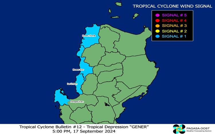
Tropical Cyclone Wind Signals (TCWS)
As of now, Tropical Cyclone Wind Signal No. 1 is in effect for several areas in Luzon. This includes:
- Ilocos Norte
- Ilocos Sur
- La Union
- Western portion of Pangasinan (Sual, Burgos, Dasol, Mabini, Infanta, Labrador, City of Alaminos, Bani, Bolinao, Anda, Agno)
The wind signal warns of strong winds ranging between 39 to 61 km/h (Beaufort 6 to 7). While these winds pose a minimal to minor threat to life and property, residents in the affected areas should remain vigilant. The warning provides a 36-hour lead time for preparation.
Other Hazards Affecting Land Areas
The Southwest Monsoon, enhanced by Tropical Depression Gener and Tropical Storm Pulasan, is expected to cause significant weather impacts. The heavy rainfall outlook has been detailed in Weather Advisory No. 29 issued at 5:00 PM today. The Southwest Monsoon will bring strong to gale-force gusts over the following regions:
- Today (17 September): Batanes, MIMAROPA, Bicol Region, Visayas, and Mindanao.
- Tomorrow (18 September): Zambales, Bataan, Pampanga, Bulacan, Metro Manila, CALABARZON, MIMAROPA, Bicol Region, Visayas, and Mindanao.
- Thursday (19 September): Isabela, Aurora, Pangasinan, Zambales, Bataan, Metro Manila, CALABARZON, MIMAROPA, Bicol Region, and Western Visayas.
Hazards Affecting Coastal Waters
Gale Warnings are in effect for several coastal waters, particularly along the western seaboard of Southern Luzon and the western and central seaboards of Visayas. These areas are expected to experience rough seas, making sea travel risky for small seacrafts and motorbancas. For more information, Gale Warning No. 7 issued at 5:00 PM today should be consulted.
In areas outside the Gale Warning zones, sea conditions are expected to be rough, with wave heights ranging from 1.0 to 3.5 meters in northern seaboards and up to 2.5 meters in other coastal waters. Mariners of small seacrafts should exercise extreme caution and avoid venturing out to sea if conditions are adverse or if they lack proper equipment.
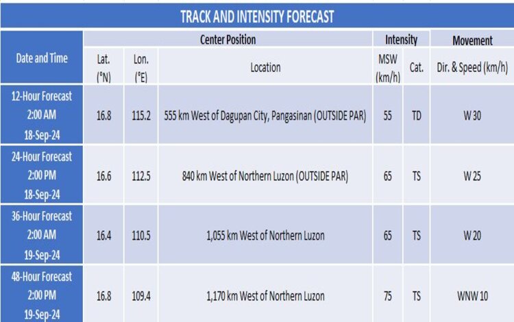
Track and Intensity Outlook
The track forecast suggests that Tropical Depression Gener will exit the Philippine Area of Responsibility (PAR) either tonight or early tomorrow morning. Once outside the PAR, Gener is expected to continue its westward path over the West Philippine Sea. There is a possibility that Gener may intensify into a tropical storm by tomorrow morning, but significant strengthening is not anticipated in the short term.
For the latest updates and warnings, residents are advised to stay tuned to official PAGASA bulletins and advisories.