At 11:00 AM today, the Philippine Atmospheric, Geophysical, and Astronomical Services Administration (PAGASA) released an update on Tropical Storm Helen (Pulasan), currently moving over the northern portion of the Philippine Sea. The storm continues its northwestward track while enhancing the Southwest Monsoon (Habagat) and impacting various regions of the Philippines with heavy rains and strong winds.
Location and Intensity
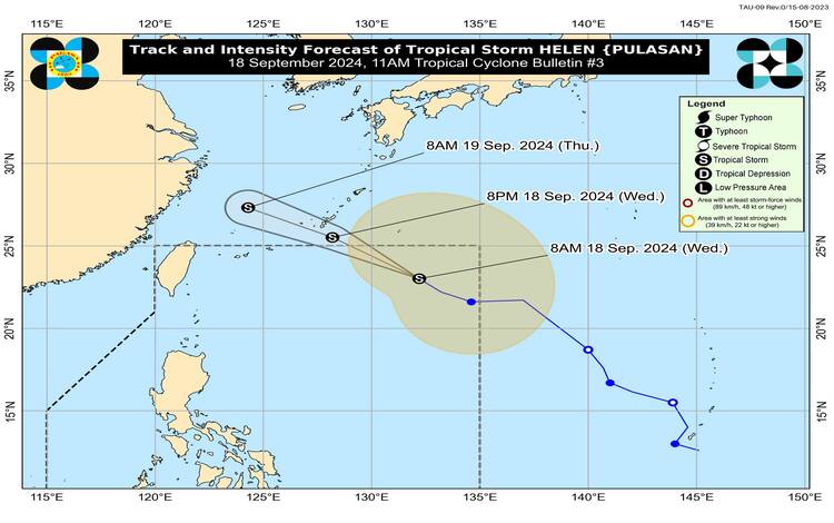
As of 10:00 AM, the center of Tropical Storm Helen was located approximately 1,060 kilometers east-northeast of Extreme Northern Luzon, at coordinates 23.5°N, 131.7°E. It carries maximum sustained winds of 85 kilometers per hour (km/h) near the center, with gustiness reaching up to 105 km/h. Helen’s central pressure is measured at 994 hPa, with its strong to gale-force winds extending up to 650 kilometers from the center.
Movement and Forecast Track
Helen is moving northwestward at a speed of 25 km/h. The storm is expected to continue this trajectory and exit the Philippine Area of Responsibility (PAR) by this afternoon or evening. Although Helen will remain far from the Philippine landmass, it is enhancing the Southwest Monsoon, which is affecting the weather in various parts of the country.
Helen is forecast to remain a tropical storm and may gradually weaken once it moves over the East China Sea. Its impact on the Philippines will primarily be through the intensified monsoon activity, rather than any direct effects.
Tropical Cyclone Wind Signals
No Tropical Cyclone Wind Signals (TCWS) are currently in effect for any area of the Philippines. However, the enhanced Southwest Monsoon is expected to bring significant winds and rainfall across several regions over the coming days.
Heavy Rainfall Outlook
PAGASA advises the public to refer to Weather Advisory No. 32, issued earlier today, for detailed information on the heavy rainfall outlook due to the combined effects of Tropical Storm Helen and Severe Tropical Storm Gener (international name: Chaba). These monsoon rains are expected to cause scattered to widespread rainfall, especially in Western Luzon, Visayas, and parts of Mindanao.
Severe Winds
The following areas may experience strong to gale-force winds today due to the enhanced Southwest Monsoon:
- September 18: Zambales, Bataan, Pampanga, Bulacan, Metro Manila, CALABARZON, MIMAROPA, Bicol Region, Visayas, Zamboanga Peninsula, Northern Mindanao, Caraga, and Davao Region.
- September 19: Ilocos Region, Isabela, Aurora, Zambales, Bataan, Metro Manila, CALABARZON, MIMAROPA, Bicol Region, Western Visayas, Negros Island Region, and Zamboanga Peninsula.
- September 20: Ilocos Region, Isabela, Aurora, Zambales, Bataan, Cavite, Batangas, Quezon, Occidental Mindoro, Marinduque, and Romblon.
Sea Conditions and Warnings
PAGASA has issued Gale Warning No. 8, effective at 5:00 AM today, covering several coastal waters, especially in Central and Southern Luzon, and Visayas. Sea travel is deemed risky for small seacrafts in these areas. Mariners are advised to avoid sailing in coastal waters where waves are forecasted to reach heights of 1.5 to 4.0 meters.
Other coastal areas not under the Gale Warning are also expected to experience rough to moderate seas, particularly along the western seaboard of Northern Luzon and Visayas.
Precautionary Measures
PAGASA reminds the public, especially those in coastal areas, to stay vigilant and avoid venturing out to sea under these hazardous conditions. Mariners operating small vessels are particularly urged to refrain from sailing, as the rough sea conditions may pose serious risks.
Next Update
The next bulletin on Tropical Storm Helen will be issued at 5:00 PM today. In the meantime, the public is encouraged to monitor updates from PAGASA and follow local authorities’ advisories for safety.