Tropical Depression Julian is steadily intensifying and may reach super typhoon status in the coming days, according to state meteorologists. The Philippine Atmospheric, Geophysical and Astronomical Services Administration (PAGASA) has raised Tropical Cyclone Wind Signal No. 1 over several areas, warning of strong winds and potential hazards.
Current Location and Strength
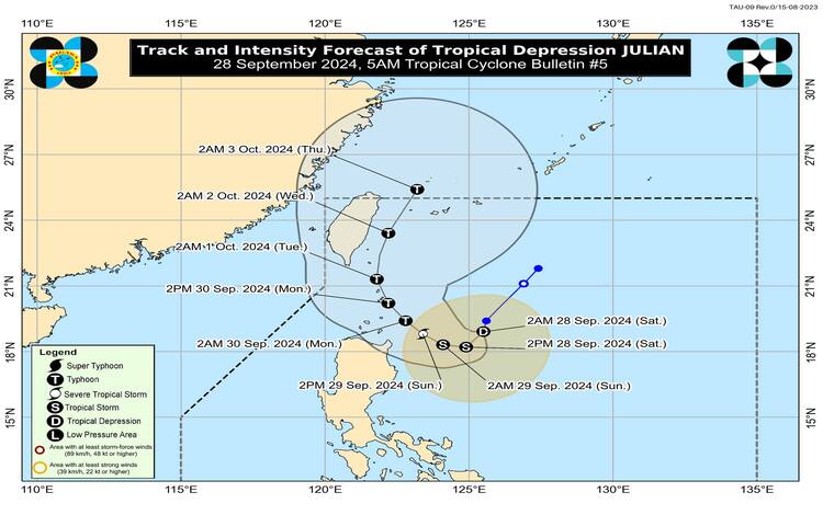
As of 4:00 AM today, Tropical Depression Julian was located 400 kilometers east of Aparri, Cagayan, at coordinates 18.6°N, 125.4°E. It is moving southward at 10 kilometers per hour, with maximum sustained winds of 55 kilometers per hour near the center and gusts reaching up to 70 kilometers per hour. The storm’s central pressure is currently 1002 hPa.
The tropical depression’s winds extend outwards up to 360 kilometers from the center, affecting coastal and nearby regions.
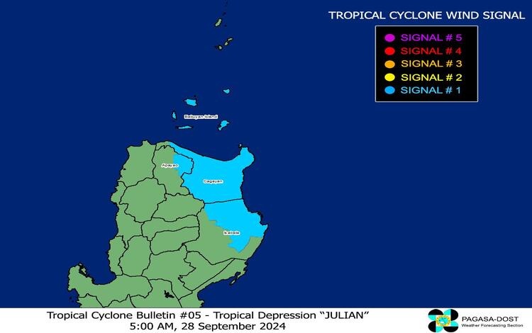
Wind Signal No. 1 Areas
PAGASA has hoisted Tropical Cyclone Wind Signal (TCWS) No. 1 over the following areas:
- Cagayan, including Babuyan Islands
- The northeastern portion of Isabela (San Pablo, Divilacan, Maconacon, Palanan, Cabagan, Santa Maria, Tumauini, Ilagan City, San Mariano, Santo Tomas, Delfin Albano)
- The eastern portion of Apayao (Luna, Pudtol, Santa Marcela, Flora)
These areas can expect strong winds within the next 36 hours, with speeds ranging from 39 to 61 kilometers per hour. Potential impacts are expected to be minimal, but residents should remain vigilant for possible power outages and minor property damage.
Heavy Rainfall Outlook
A heavy rainfall outlook has also been issued, and residents in the affected regions should prepare for flash floods and landslides, especially in low-lying and mountainous areas. PAGASA’s Weather Advisory No. 5, released earlier today, contains specific details on the rainfall forecast.
Future Intensification and Possible Landfall
Tropical Depression Julian is expected to intensify further, potentially becoming a tropical storm by Saturday morning and a typhoon by Sunday. PAGASA warns that Julian could make landfall over Batanes by Monday afternoon or evening. While the current wind signals remain low, Julian may trigger Wind Signal No. 4 in the coming days as it strengthens into a possible super typhoon.
The cyclone is forecast to follow a looping track over the waters east of Batanes and Cagayan. Over the next 12 hours, it is expected to move southwestward before turning westward this afternoon while slowing down. By Sunday, Julian will gradually shift northwestward and continue in this direction until Tuesday. Afterward, the system will veer northward and eventually exit the Philippine Area of Responsibility (PAR) by Wednesday evening or early Thursday morning.
Hazards Affecting Coastal Waters
PAGASA has issued advisories regarding hazardous sea conditions. Rough seas, with waves up to 4.0 meters high, are expected in the coastal waters of Batanes, Babuyan Islands, and the eastern seaboard of Cagayan. Mariners, particularly those operating small vessels, are strongly advised not to venture to sea under these dangerous conditions. Gale warnings will also likely be hoisted soon in Northern Luzon’s seaboard.
General Flood Advisories
General flood advisories have been issued for the following regions:
- Cordillera Administrative Region (CAR) – GFA #2
- Ilocos Region (Region 1) – GFA #2
- Cagayan Valley (Region 2) – GFA #3
Residents in these regions are advised to monitor updates and take necessary precautions, especially those in flood-prone areas.
Precautionary Measures
Residents of areas under Wind Signal No. 1 and those in coastal and mountainous regions exposed to strong winds should take precautions as winds and rain intensify. PAGASA also encourages local authorities to enforce necessary evacuations in vulnerable areas to prevent loss of life.
With the potential for rapid intensification, the possibility of Julian becoming a super typhoon cannot be ruled out.