The Philippine Atmospheric, Geophysical and Astronomical Services Administration (PAGASA) has raised warnings for Northern Luzon as Super Typhoon “Julian” (international name: KRATHON) continues to intensify while moving slowly west-northwestward. As of 4:00 AM today, the center of Super Typhoon Julian was located approximately 205 kilometers west of Itbayat, Batanes (20.6°N, 119.9°E). The storm packs maximum sustained winds of 185 km/h near the center, gusts reaching up to 230 km/h, and a central pressure of 925 hPa.
Movement and Wind Signals
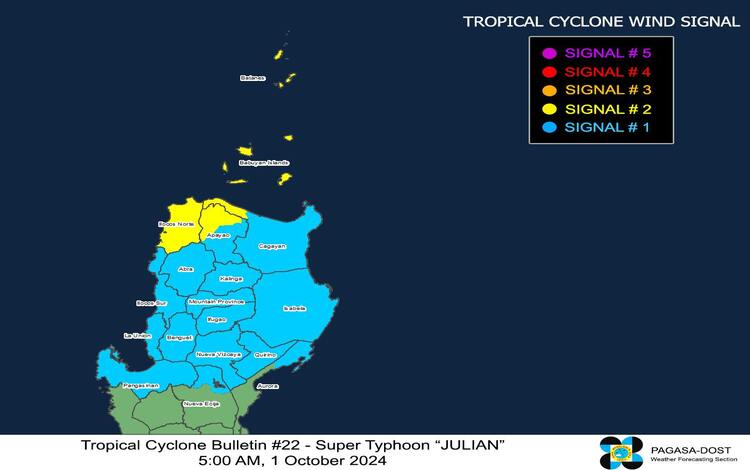
Julian is now moving west-northwestward slowly, with its vast wind field extending up to 620 kilometers from the center. Currently, Tropical Cyclone Wind Signal (TCWS) No. 2 is in effect for Batanes, Babuyan Islands, northern Ilocos Norte, and northwestern Cagayan. Residents in these areas should prepare for gale-force winds ranging from 62 to 88 km/h, with potential minor to moderate impacts on life and property.
Areas under TCWS No. 1, including the rest of Ilocos Norte, Ilocos Sur, La Union, Pangasinan, and parts of Aurora, should also brace for strong winds of 39 to 61 km/h within the next 36 hours. Minimal to minor impacts are expected in these regions.
Heavy Rainfall and Severe Winds
Although PAGASA has yet to issue the specific rainfall advisory today, the weather bureau warns of severe winds, especially in coastal and upland areas. Regions under TCWS No. 2 should anticipate minor to moderate impacts from gale-force winds. Meanwhile, areas under TCWS No. 1 may experience strong winds with minimal to minor effects.
Coastal and upland areas exposed to strong winds should be prepared for intensified gusts, especially in Northern Luzon, including parts of the Ilocos Region, Cordillera Administrative Region, and Cagayan Valley. By tomorrow (October 2), these gusts will extend to regions such as Metro Manila, Zambales, and CALABARZON.
Coastal Hazards
PAGASA has issued Storm Surge Warning No. 7, cautioning that a moderate to high risk of life-threatening storm surges exists for the low-lying coastal areas of Batanes and Babuyan Islands within the next 48 hours. Residents in these areas are urged to take precautionary measures and evacuate if necessary.
Additionally, a Gale Warning is in place for the northern and western seaboard of Northern Luzon, with wave heights reaching up to 7.0 meters in the seaboard of Batanes. Sea conditions are also very rough in Babuyan Islands and Ilocos Norte, where waves could reach 6.0 meters, posing a significant risk for maritime activities. Mariners are advised to remain in port or seek safe harbor until conditions improve.
Forecast Track and Outlook
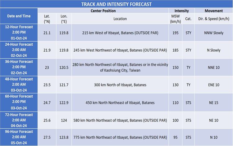
Super Typhoon Julian is forecast to recurve towards the sea southwest of Taiwan today, continuing on a west-northwestward path. The storm is expected to land on Taiwan’s southwestern coast by tomorrow, October 2, before weakening as it crosses the island’s rugged terrain. By Thursday (October 3), Julian is projected to move northeastward into the East China Sea, gradually exiting the Philippine Area of Responsibility (PAR) by Thursday afternoon or evening.
PAGASA also highlights the possibility of further intensification in the next 24 hours before the typhoon encounters Taiwan’s mountainous landscape, which could lead to a downgrade in intensity. By Thursday, Julian is expected to weaken into a severe tropical storm as it moves towards the East China Sea.
Local Weather Conditions
In the affected areas of Northern Luzon, stormy weather conditions will prevail, particularly in Batanes, Cagayan, and Ilocos Norte. Rain with gusty winds is anticipated in surrounding regions, including Isabela, Quirino, Nueva Vizcaya, and Ilocos Sur. Coastal waters will remain rough to very rough, with waves reaching up to 4.5 meters in the seaboard of Ilocos Sur.
Residents in the impacted areas are urged to stay vigilant, adhere to the guidance of local authorities, and monitor updates from PAGASA as Super Typhoon Julian continues its path across Northern Luzon.