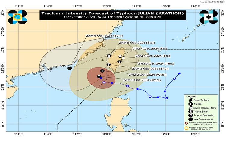
Typhoon “Julian” (international name: KRATHON) has continued to weaken as it inches slowly toward Taiwan. As of 4:00 AM today, the center of the typhoon was located 280 kilometers west-northwest of Itbayat, Batanes, and remains outside the Philippine Area of Responsibility (PAR). Despite its weakening, Julian is still packing maximum sustained winds of 165 km/h near its center, with gusts reaching up to 205 km/h and a central pressure of 945 hPa. The typhoon is currently moving northwest at a slow pace.
Typhoon Signals and Affected Areas
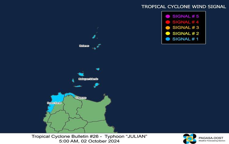
PAGASA has issued Tropical Cyclone Wind Signal (TCWS) No. 1 for certain areas in Luzon due to strong winds. These areas include Batanes, Babuyan Islands, the northern and western parts of Ilocos Norte, and parts of northwestern mainland Cagayan, including Santa Praxedes and Sanchez-Mira.
The wind signal indicates that these regions may experience 39 to 61 km/h winds in the next 36 hours. While these wind speeds are not expected to cause significant damage, residents in coastal and mountainous areas are advised to remain vigilant as stronger winds may be felt in such regions.
PAGASA warns that minor impacts to life and property may occur within these areas, although the overall threat is minimal.
Rainfall and Coastal Conditions
According to the weather bureau, the rainfall outlook for Typhoon Julian remains a significant concern. As of 5:00 AM, Weather Advisory No. 26 was issued, detailing the heavy rainfall outlook for affected areas. Despite weakening, Julian may still bring moderate to heavy rains in northern Luzon and its nearby islands. Residents in low-lying and mountainous areas should be alert for flooding and landslides.
A Gale Warning has also been raised, particularly for the northern seaboard of Northern Luzon. Very rough sea conditions are expected in the following areas:
- Batanes (waves up to 5.0 meters)
- Babuyan Islands (waves up to 4.5 meters)
- Northern Ilocos Norte (waves up to 4.5 meters)
Given these conditions, sea travel is highly risky, especially for small vessels and motorbancas. Mariners are advised to stay in port or seek safe harbor. Moderate to rough seas are also expected in other coastal regions, including the seaboard of Zambales, Isabela, and Cagayan, where waves can reach up to 4.0 meters. Fisherfolk and mariners are strongly discouraged from venturing out into these waters.
Forecast Track and Typhoon’s Intensity
Typhoon Julian is forecast to continue its slow movement toward Taiwan, with landfall expected either late tonight or early tomorrow morning along Taiwan’s southwestern coast. After making landfall, Julian is anticipated to move erratically over Taiwan’s landmass and coastal waters before reemerging over the Taiwan Strait by Friday night or early Saturday morning.
As Julian approaches Taiwan, it will be impacted by a combination of factors, including cooler waters and an incoming northeasterly wind flow from the East China Sea. These conditions will likely cause further weakening, and the typhoon is expected to become a remnant low by the weekend.
At this time, no other dominant weather system is significantly influencing Julian’s general movement, which means changes in its forecast track could still occur in future updates. PAGASA advises the public to stay tuned for the latest bulletins and to continue monitoring weather advisories, especially in northern Luzon.
Public Advisory
Residents in areas under TCWS No. 1 should prepare for strong winds and potential disruptions, such as light structural damage and tree branches breaking. Those living in flood-prone or landslide-prone areas are advised to stay alert and heed any evacuation orders from local authorities.
Mariners are urged to avoid sailing in affected coastal waters due to dangerous sea conditions. As the typhoon’s movement remains slow and unpredictable, frequent updates from PAGASA are critical to ensure public safety.