As of 4:00 AM today, October 3, 2024, Typhoon Julian (international name: Krathon) continues to weaken as it slowly moves northeastward towards Taiwan. The storm’s center is now located approximately 265 km northwest of Itbayat, Batanes, outside the Philippine Area of Responsibility (PAR). Currently, Typhoon Julian has maximum sustained winds of 140 km/h, gustiness of up to 170 km/h, and a central pressure of 965 hPa.
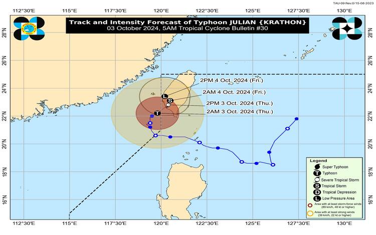
Despite its gradual weakening, Julian still poses a risk with its strong winds extending up to 280 kilometers from its center. The storm’s slow northeastward movement is influenced by incoming northeasterly winds and lower ocean heat content, contributing to its ongoing weakening.
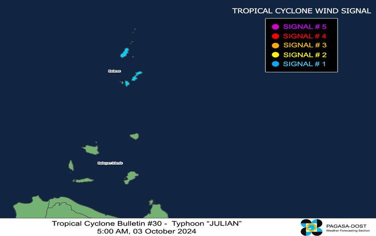
Tropical Cyclone Wind Signal No. 1 Raised Over Batanes
As of the latest update, Tropical Cyclone Wind Signal (TCWS) No. 1 remains in effect over Batanes. Under this signal, strong winds ranging from 39 to 61 km/h are expected within the next 36 hours. While these winds pose minimal to minor threats to life and property, the public is still advised to take necessary precautions, particularly in coastal and mountainous areas where local winds could be stronger.
Hazardous Sea Conditions
A Gale Warning has been issued for the northern seaboard of Northern Luzon, with very rough seas expected. The seas around Batanes may reach heights of up to 4.5 meters, making sea travel risky for all types of vessels, especially small watercraft. Mariners are strongly advised to remain in port or seek safe shelter.
In addition, moderate to rough seas are forecast over the seaboards of the Babuyan Islands and Ilocos Norte, with waves reaching up to 4.0 meters. Other areas affected include the seaboards of the Ilocos Region, Zambales, Lubang Island, Calamian Islands, and Kalayaan Islands, with waves ranging from 2.5 to 3.5 meters. Mariners, particularly those operating small boats, are urged to avoid venturing out to sea in these conditions.
Forecast and Future Movement
Typhoon Julian is expected to make landfall in southwestern Taiwan later today. Due to land interaction and upwelling of cooler waters caused by its slow movement, the typhoon will continue to weaken. After making landfall, Julian is forecast to move erratically over Taiwan and may weaken further into a remnant low by October 4.
General Flood Advisories
Flood advisories have been issued for several regions, including CAR (Cordillera Administrative Region), Region 1 (Ilocos Region), Region 2 (Cagayan Valley), Region 11 (Davao Region), and Region 13 (CARAGA). Residents in these areas are advised to monitor local warnings and prepare for potential flooding.