Tropical Depression “Kristine” continues to maintain its strength as it moves west-southwestward over the Philippine Sea, posing potential impacts on various parts of the country. The latest update from the Philippine Atmospheric, Geophysical, and Astronomical Services Administration (PAGASA) provides crucial details regarding Kristine’s current position, intensity, and forecasted path.
Current Location and Movement
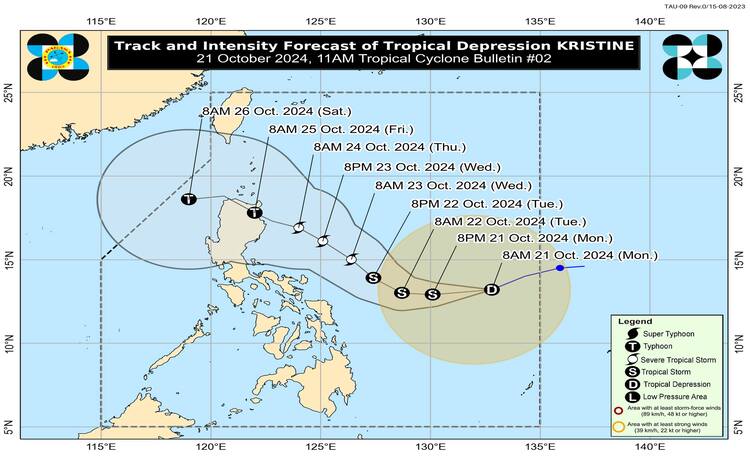
As of 10:00 AM today, Tropical Depression Kristine was located approximately 870 km east of Eastern Visayas, near coordinates 13.2°N, 132.6°E. The system is moving west-southwestward at a speed of 30 km/h.
Intensity and Extent
Kristine is currently packing maximum sustained winds of 55 km/h near the center, with gusts reaching up to 70 km/h. The tropical depression has a central pressure of 1000 hPa, indicating its growing intensity. Strong winds associated with Kristine extend outward up to 550 km from the center, affecting a large area in its path.
Tropical Cyclone Wind Signals (TCWS)
PAGASA has raised Tropical Cyclone Wind Signal No. 1 over the following areas due to the expected strong winds:
Luzon:
- Catanduanes
- Masbate (including Ticao and Burias Islands)
- Camarines Sur, Albay, Sorsogon, Camarines Norte
- Eastern portion of Quezon (Tagkawayan, Guinayangan, Buenavista, San Narciso, San Andres)
Visayas:
- Eastern Samar, Northern Samar, Samar, Leyte, Biliran, Southern Leyte
Mindanao:
- Dinagat Islands
- Surigao del Norte (including Siargao and Bucas Grande Group)
These areas are expected to experience wind speeds ranging from 39 to 61 km/h, with minimal to minor threats to life and property. PAGASA advises the public to remain vigilant, as TCWS No. 1 typically signals a 36-hour lead time for strong winds.
Rainfall and Wind Outlook
The heavy rainfall forecast due to Kristine can be found in PAGASA’s Weather Advisory No. 3, issued earlier today. The public is advised to stay updated, as severe winds will impact coastal and upland areas exposed to the cyclone. Winds may be stronger in these areas, while more sheltered regions could experience less intense gusts.
The highest wind signal that could be raised as Kristine intensifies may reach TCWS No. 4, depending on its development. In addition, gale-force winds are expected today and tomorrow in areas such as Batanes, Cagayan, Ilocos Norte, and the southern portions of Palawan and Mindanao.
Coastal Waters and Sea Conditions
PAGASA has also issued warnings regarding sea conditions, with moderate to rough seas expected over several areas, including the seaboards of Isabela, Aurora, Catanduanes, and Northern Samar. Waves could reach up to 4.5 meters, posing risks to mariners, especially those operating small sea vessels. A gale warning is likely to be raised in the coming hours.
Forecast Track and Intensification
Tropical Depression Kristine is forecast to move westward until tomorrow (October 22) before shifting northwestward. The system is expected to make landfall over Northern Luzon by Friday, October 25. As Kristine traverses the Philippine Sea, it is projected to intensify into a tropical storm within the next 12 hours. It could reach severe tropical storm status by Wednesday (October 23) and possibly evolve into a typhoon by Thursday (October 24) or Friday morning.

PAGASA emphasizes that further intensification is likely due to favorable environmental conditions, such as high sea surface temperatures and low wind shear. However, changes in the forecast track remain possible depending on the movement of weather systems in the coming days.
The public is advised to stay updated with the latest bulletins and advisories to ensure safety as Kristine continues to develop. The next update is expected at 5:00 PM today.