According to the latest weather bulletin from the Philippine Atmospheric, Geophysical, and Astronomical Services Administration (PAGASA), Typhoon Kristine (international name “Trami”) slightly intensified while moving over the sea east of Quezon as of 5:00 AM today. This tropical storm is expected to affect a wide area of Luzon, Visayas, and Mindanao.
Typhoon Position and Strength
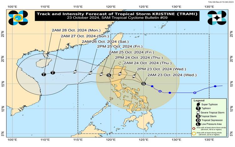
At 4:00 AM, the center of Typhoon Kristine was located 340 kilometers east of Infanta, Quezon, or about 180 kilometers north-northeast of Virac, Catanduanes. Near the center, it had maximum sustained winds of 85 km/h, with gusts reaching up to 105 km/h. The central pressure is estimated at 985 hPa. The storm is moving west-northwestward at 25 km/h, and gale-force winds extend outward up to 850 kilometers from the center.
Wind Signals and Areas Affected
PAGASA raised Tropical Cyclone Wind Signals (TCWS) in multiple areas as the storm threatens to bring gale-force winds and heavy rainfall. Wind Signal No. 2 is hoisted in parts of Luzon, including Ilocos Norte, Ilocos Sur, La Union, Pangasinan, Apayao, Abra, Kalinga, Mountain Province, Ifugao, Benguet, Cagayan, Isabela, Quirino, and parts of Quezon and Camarines provinces, among others. This signal indicates potential winds of 62 to 88 km/h within 24 hours, posing a moderate threat to life and property.
In addition, Wind Signal No. 1 is in effect for the rest of Luzon, including Metro Manila, as well as parts of Visayas and Mindanao. Areas under Signal No. 1 may experience winds of 39 to 61 km/h in the next 36 hours, which could cause minimal to minor damage.
Rainfall and Wind Hazards
Heavy rainfall is expected, particularly in areas under Wind Signal No. 2. PAGASA advises residents in these regions to be prepared for flooding, landslides, and storm surges, especially in low-lying and coastal areas. The storm’s winds, especially in upland and coastal areas, could bring moderate impacts, such as damage to structures made of light materials and minor disruptions to power lines and communication networks.
A storm surge warning has been issued for coastal areas in Ilocos Norte, Ilocos Sur, La Union, Pangasinan, Cagayan, Isabela, Zambales, Aurora, and Catanduanes. There is a moderate to significant risk of life-threatening storm surges over these areas within the next 48 hours.
Sea Condition and Gale Warning
A Gale Warning is in effect for the seaboards of Luzon and Visayas, where sea conditions are expected to be rough, with waves reaching up to 8 meters. PAGASA strongly advises against sea travel, especially for small seacrafts. Mariners are advised to stay in port or seek shelter until the weather improves.

Typhoon Kristine’s Track
Typhoon Kristine is forecast to move northwestward over the next 24 hours before turning westward. It is expected to make landfall over Isabela or northern Aurora by tonight or early tomorrow morning (October 24). After crossing Northern Luzon, it is forecast to exit the Philippine Area of Responsibility (PAR) by Friday, October 25, 2024. Kristine is projected to intensify into a severe tropical storm before landfall, followed by a slight weakening while traversing the mountainous terrain of Northern Luzon.
PAGASA continues to monitor the storm closely and will issue updates as necessary. Residents in affected areas are urged to take precautionary measures and stay updated on the latest weather advisories.