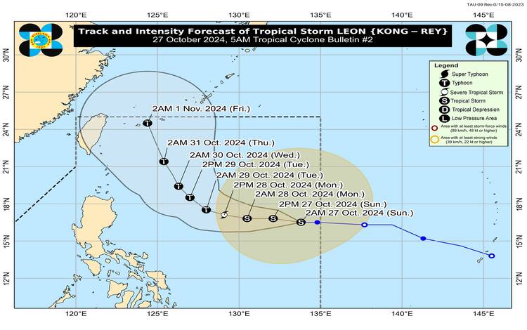
Tropical Storm Leon (internationally known as Kong-rey) has maintained its strength as it progresses westward across the Philippine Sea. Positioned approximately 1,195 km east of Central Luzon (16.4°N, 133.3°E) as of 4:00 AM today, Leon is moving at 20 km/h. Near its center, maximum sustained winds are 65 km/h, and gustiness can reach up to 80 km/h. The storm has a central pressure of 994 hPa, while its strong to gale-force winds extend to 640 km from the center.
Tropical Cyclone Wind Signals (TCWS) and Potential Impacts
No Tropical Cyclone Wind Signals are hoisted over any part of the Philippines. However, given Leon’s anticipated trajectory, authorities may hoist Wind Signal No. 1 over portions of Cagayan Valley and the northeastern part of the Bicol Region by this evening. Should the storm track shift westward, there remains a possibility of Wind Signal No. 2 being raised in certain areas. Residents in potentially affected areas are advised to remain alert for any updates on wind signals, particularly in the coming days.
Heavy Rainfall and Wind Forecast
Although Tropical Storm Leon is not expected to directly impact Philippine weather conditions in the short term, its rainbands might influence the extreme northern regions of Luzon if it moves closer. The outer circulation of Leon may also enhance the existing southwesterly wind flow previously triggered by Severe Tropical Storm Trami (formerly “Kristine”). This intensification may bring increased rain and wind activity across parts of Southern Luzon, Visayas, and Mindanao in the days ahead.
For today, strong to gale-force gusts are likely to affect coastal and upland areas of Catanduanes, Northern Samar, Eastern Samar, and Dinagat Islands. These conditions are expected to spread on October 28 to Northern Samar, Romblon, Masbate (including Burias and Ticao Islands), northern Antique, Capiz, southern Negros Oriental, Siquijor, Southern Leyte, Dinagat Islands, and parts of Mindanao, including Surigao del Norte and Davao regions. By October 29, the gusty winds may extend to Batangas, Oriental Mindoro, Camarines Norte, Camarines Sur, Catanduanes, and other northern parts of the Visayas.
Marine and Coastal Hazards
Pagasa also issued a 24-hour sea condition outlook, warning mariners of potential rough seas. Expected wave heights are as follows:
- Up to 3.0 meters along the western seaboard of Luzon,
- Up to 2.5 meters along the northern and eastern seaboards of Northern Luzon, Catanduanes, Northern Samar, and Eastern Samar, and
- Up to 2.0 meters for remaining seaboards of Luzon, Visayas, and parts of Mindanao.
Due to these conditions, smaller vessels are advised to exercise caution or avoid sea travel if possible, as navigating under these circumstances may be hazardous.
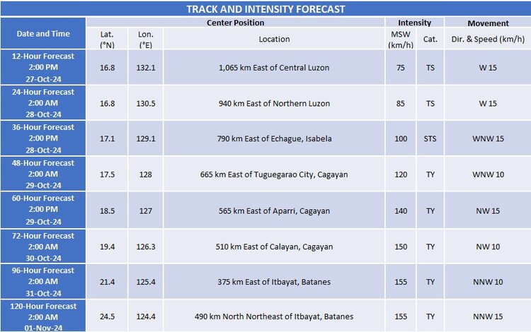
Track and Intensity Forecast
Tropical Storm Leon is expected to continue moving westward until tomorrow morning (October 28), after which it may shift to a west-northwest path, potentially turning further northwestward by October 29. This northwestward path could lead Leon to make landfall over Japan’s Ryukyu Islands in Okinawa by November 1. Although Leon remains distant from the Philippine mainland, its track forecast might change within the 4-5 day forecast window, possibly edging closer to the country’s northern territories.
In terms of intensity, Leon is forecast to gradually strengthen over the next 24 hours, possibly reaching severe tropical storm status by tomorrow. Rapid intensification may occur from October 28 to October 30, potentially elevating Leon to a typhoon by the evening of October 28 or early morning on October 29.
Advisory
Pagasa urges the public and local authorities to monitor future bulletins on Tropical Storm Leon. Updated forecasts, wind signals, and rainfall advisories will be issued as needed, particularly if there are significant shifts in the storm’s path or intensification.