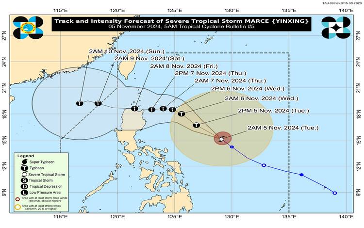
As of early morning today November 5, 2024, Severe Tropical Storm Marce (international name: Yinxing) has intensified slightly and is moving closer to typhoon status. It remains approximately 735 kilometers east of Baler, Aurora, as tracked by the Philippine Atmospheric, Geophysical and Astronomical Services Administration (Pagasa). Residents of Luzon, particularly those in areas under Tropical Cyclone Wind Signal No. 1, are advised to prepare for potential impacts as Marce continues to strengthen.

Current Storm Details
- Location: 735 km East of Baler, Aurora (15.7°N, 128.5°E)
- Intensity: Maximum sustained winds of 110 km/h near the center, with gustiness reaching up to 135 km/h and a central pressure of 975 hPa
- Movement: Heading northwest at a speed of 25 km/h
- Wind Field Extent: Strong to storm-force winds extending up to 580 km from the center
Tropical Cyclone Wind Signals in Effect
Pagasa has raised Tropical Cyclone Wind Signal No. 1 over parts of Luzon, including Batanes, Cagayan (including the Babuyan Islands), portions of Isabela, northern Apayao, and parts of Ilocos Norte. Areas under this signal may experience strong winds within the next 36 hours, with wind speeds ranging from 39 to 61 km/h. Minimal to minor impacts are expected on life and property.

Weather Hazards Affecting Land Areas
- Heavy Rainfall: Rain advisories are in effect for areas in Luzon, as issued in Pagasa’s Weather Advisory No. 2 at 5:00 AM today. While direct rainfall impacts are still limited, heavy rain may occur along Marce’s track in the coming days, particularly as it nears landfall.
- Severe Winds: Moderate to severe winds are anticipated in areas under Signal No. 1, especially in coastal and elevated regions. Localized wind conditions may be stronger in exposed coastal and mountain areas. Pagasa has also cautioned that Wind Signal No. 4 may be necessary if Marce’s intensity increases further.
- Strong Winds from Northeasterly Flow: Alongside Marce’s circulation, northeasterly winds are expected to bring gusts over parts of Ilocos, Aurora, Quezon, and the Bicol Region through Thursday. Gusts will be particularly strong in exposed coastal and upland areas.
Coastal Hazards and Sea Conditions
- Gale Warning: Gale warnings are in effect for Northern Luzon’s northern and eastern coastal regions. Mariners are urged to heed Gale Warning No. 1 and avoid sea travel in these regions due to waves reaching up to 4.5 meters. The seaboards of Batanes, Cagayan, Babuyan Islands, and Isabela will experience very rough seas, with similar conditions expected in Ilocos Norte, Aurora, and Camarines Norte.
- Advised Precautions for Mariners: Small vessels and inexperienced seafarers are advised to remain in port. Those operating motorized bancas should avoid sailing, especially as sea conditions worsen along the northern seaboards of Luzon and eastern Quezon.
Track and Intensity Forecast
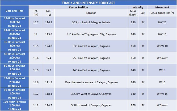
Marce is forecast to move generally northwestward through the Philippine Sea until tomorrow morning. As it approaches Northern Luzon, it may decelerate, then shift to a westward direction, bringing it near the Babuyan Islands or northern Cagayan by Thursday evening or early Friday. Marce could intensify into a typhoon by today and may reach peak intensity just before landfall.
Following its landfall, Marce is expected to exit the Philippine Area of Responsibility (PAR) between Friday evening and Saturday morning. However, slight shifts in the track remain possible due to influences from the high-pressure area to the north of Marce.

Public Safety Advisory
Pagasa urges residents in affected areas to stay informed and take precautions to protect life and property. Those in flood- and landslide-prone areas should prepare for possible evacuation, while residents along coastal areas should monitor updates on sea conditions. Local authorities may announce further safety measures as Marce approaches.
For the latest advisories on rainfall, wind warnings, and severe weather updates, residents should follow Pagasa’s bulletins.
