As of early morning on November 6, 2024, Typhoon Marce continues to intensify as it moves northwestward over the Philippine Sea. The Philippine Atmospheric, Geophysical, and Astronomical Services Administration (Pagasa) has issued updates on the typhoon’s location, strength, and potential impacts as it threatens to bring strong winds, heavy rainfall, and dangerous sea conditions to parts of Northern Luzon. Marce, with maximum sustained winds of 140 km/h and gusts up to 170 km/h, is currently located approximately 345 kilometers east of Tuguegarao City, Cagayan, moving northwestward at a speed of 15 km/h.

Wind Signals and Expected Impacts
Pagasa has raised Tropical Cyclone Wind Signals (TCWS) in affected areas to warn residents of incoming wind threats:
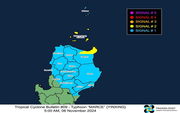
- TCWS No. 2 is in effect for the eastern portion of Babuyan Islands (Camiguin Island, Babuyan Island) and northeastern Cagayan (Santa Ana, Gonzaga, Lal-Lo, Santa Teresita, and Buguey). Residents here can expect gale-force winds of 62 to 88 km/h within the next 24 hours. The impact could be minor to moderate, with potential damage to light structures and vegetation.
- TCWS No. 1 is raised over Batanes, the rest of Cagayan, including Babuyan Islands, Ilocos Norte, Ilocos Sur, Apayao, Abra, Kalinga, Mountain Province, Ifugao, northern Benguet, Isabela, Nueva Vizcaya, Quirino, and northern Aurora. These areas may experience wind speeds of 39 to 61 km/h over the next 36 hours, with minimal to minor impacts expected.
Depending on its trajectory and intensification, Signal No. 4 is the highest wind signal that may be raised for Typhoon Marce.
Rainfall and Severe Winds
Typhoon Marce is expected to bring intense rainfall across Northern Luzon. Pagasa has warned of potential flooding and landslides in areas under TCWS No. 2, especially those with steep terrain or high soil saturation. Residents are urged to stay updated with the latest Weather Advisory, particularly Advisory No. 6 issued at 5:00 AM today, for specific rainfall information.
Pagasa has advised people under TCWS No. 1 and TCWS No. 2 to secure their homes and prepare for moderate to severe wind impacts. Stronger winds are anticipated in coastal and upland regions directly exposed to the typhoon’s force. Localized gustiness may be experienced in areas affected by the northeast monsoon (Amihan), which is expected to enhance wind speeds in northern Luzon, Quezon, and parts of Bicol.

Coastal Hazards and Sea Conditions
Marce poses a significant storm surge threat, with waves potentially reaching between 2.0 to 3.0 meters above the usual tide levels. Storm Surge Warning No. 3, issued at 2:00 AM, highlights the risk for vulnerable coastal communities in Batanes, Cagayan (including the Babuyan Islands), Isabela, and parts of Ilocos Norte and Ilocos Sur. Evacuation measures and additional safety precautions are recommended for these areas, as storm surge events can be life-threatening.
A Gale Warning is currently in place for Northern Luzon’s seaboard and Central Luzon’s eastern seaboard. Sea conditions are predicted to be extremely rough, with waves reaching up to 8.0 meters in some areas, including northeastern Cagayan and Babuyan Islands. Mariners are strongly advised against sea travel and urged to remain in port or seek safe harbor until conditions improve. Smaller vessels, particularly motorbancas, should avoid sea navigation, as moderate to rough seas are expected even in less exposed areas, including Albay, Sorsogon, and portions of Northern and Eastern Samar.
Typhoon Marce’s Forecasted Path
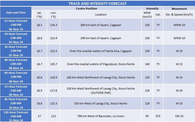
Marce is anticipated to continue its west-northwest movement today, approaching Babuyan Islands and northern Cagayan by Thursday (November 7) or early Friday (November 8). The typhoon could make landfall or pass close to these areas within the next 48 hours before exiting the Philippine Area of Responsibility (PAR) by Friday evening. Marce is expected to intensify further, potentially reaching peak intensity before making landfall or skimming past the northernmost regions of Luzon.
Pagasa continues to monitor Typhoon Marce closely and will issue timely updates for affected regions. Residents in affected areas are encouraged to stay vigilant, secure loose objects, and prepare for possible evacuations.
