As of 5:00 PM, the Philippine Atmospheric, Geophysical, and Astronomical Services Administration (PAGASA) has issued its latest advisory on Typhoon “NIKA,” which continues its path over Luzon. Currently moving over the Cordillera Administrative Region, Typhoon “NIKA” is bringing significant wind and rain impacts across Northern Luzon, prompting heightened alerts and extensive Tropical Cyclone Wind Signals (TCWS) across multiple regions.

Location and Intensity
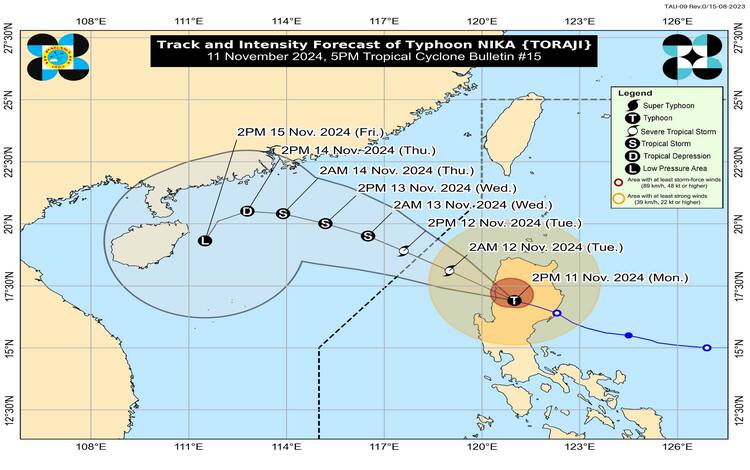
At 4:00 PM, the center of Typhoon “NIKA” was positioned near Besao, Mountain Province (17.1°N, 120.8°E). The storm maintains maximum sustained winds of 120 km/h near its center, with gusts reaching up to 200 km/h and a central pressure of 970 hPa. Moving at a west-northwestward pace of 25 km/h, NIKA’s reach is expansive, with strong to typhoon-force winds extending outward up to 340 km from its center.
Tropical Cyclone Wind Signals in Effect
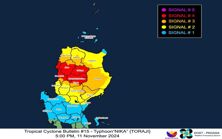
The following TCWS levels are in place for areas across Luzon, with Signal No. 4 signaling the most severe threat:
- TCWS No. 4: Regions under Signal No. 4 are bracing for typhoon-force winds (118 to 184 km/h) and could experience significant to severe impacts on life and property. Areas affected include parts of Kalinga, Mountain Province, and sections of Ilocos Sur and Abra.
- TCWS No. 3: These areas are preparing for storm-force winds (89 to 117 km/h), posing a moderate to significant threat. Localities affected include portions of Quirino, Nueva Vizcaya, and Isabela, as well as the southern parts of Apayao and Ilocos Norte.
- TCWS No. 2: Gale-force winds (62 to 88 km/h) are anticipated in regions under Signal No. 2, where minor to moderate impacts may occur. Localities under this signal include parts of Cagayan, Isabela, Nueva Vizcaya, Apayao, and Benguet.
- TCWS No. 1: Strong winds (39 to 61 km/h) are expected in areas under Signal No. 1, posing minimal to minor threats. This signal covers a broad range of locations, including the Babuyan Islands, parts of mainland Cagayan, Aurora, Zambales, and portions of Quezon Province.

Heavy Rainfall and Coastal Inundation
PAGASA’s 5:00 PM Weather Advisory (No. 15) highlights the outlook for heavy rainfall associated with Typhoon NIKA. Significant rainfall is anticipated, which may lead to flash floods and landslides, especially in upland and mountainous areas. Residents in affected areas are urged to remain vigilant for localized flooding and landslide warnings.
Additionally, a moderate to high risk of storm surge is in effect for low-lying and exposed coastal areas of Ilocos Norte, Ilocos Sur, La Union, Pangasinan, and Cagayan, including the Babuyan Islands. In these areas, storm surges may result in coastal inundation over the next 48 hours, further heightening the need for evacuation and other preventive measures.
Coastal Waters and Gale Warning
PAGASA has also issued Gale Warning No. 4 for the eastern, northern, and western seaboards of Northern Luzon, warning of extremely rough seas with wave heights reaching up to 5.5 meters. Coastal waters along the eastern seaboard of mainland Cagayan, Isabela, and Ilocos Sur are particularly dangerous, and sea travel is not advised for all vessel types. Mariners are urged to remain in port or seek immediate shelter until winds and wave conditions subside.
Track and Intensity Outlook
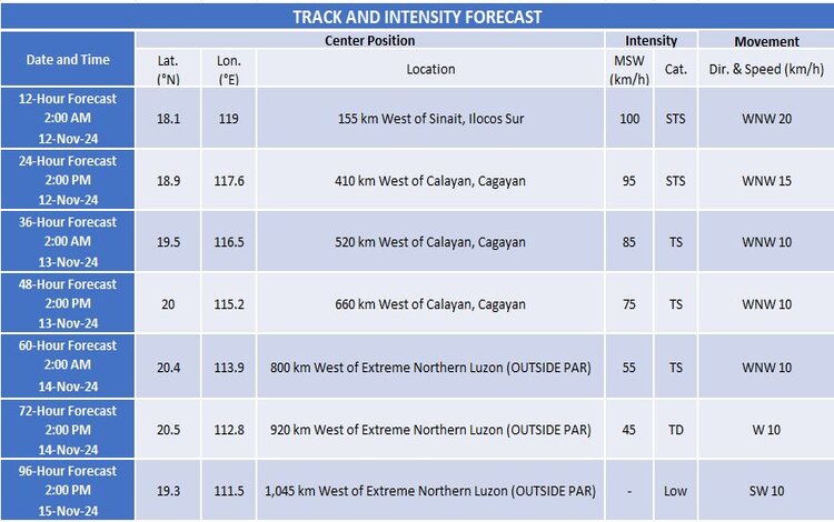
PAGASA forecasts that Typhoon “NIKA” will continue traversing the Luzon landmass today and may emerge over the sea west of Ilocos Sur by tonight. As NIKA progresses west-northwestward, it is expected to exit the Philippine Area of Responsibility (PAR) by tomorrow morning, November 12. A weakening trend may occur as the typhoon interacts with Luzon’s terrain, and NIKA could downgrade to a severe tropical storm before becoming a remnant low near southern China.
Impact Forecast and Safety Advisories
The areas currently under TCWS No. 4 should brace for significant to severe impacts due to typhoon-force winds, which can cause widespread disruption, and infrastructure damage, and pose severe risks to life and property. Those in regions under TCWS Nos. 3 and 2 should anticipate moderate to significant impacts and prepare accordingly.
The public is strongly advised to follow all local government unit (LGU) orders, including potential evacuations, particularly for those in coastal and mountainous areas vulnerable to flooding and landslides. Furthermore, NIKA’s northeasterly wind flow could bring strong gale-force gusts to areas like Batanes, Bataan, Cavite, Batangas, and other exposed locales through tomorrow, especially affecting coastal and upland regions.

Precautionary Measures
Residents in affected areas should stay indoors, secure loose outdoor items, and prepare emergency kits. Mariners and those in coastal areas are advised to remain on alert and avoid sea travel during this period. Additionally, all are urged to monitor PAGASA’s updates and advisories for the latest information on Typhoon NIKA.
As Typhoon NIKA continues its passage through Luzon, PAGASA underscores the importance of preparedness and caution to minimize the typhoon’s impact. For real-time updates, the public is encouraged to follow PAGASA’s advisories through their website, social media platforms, and partner media channels.
