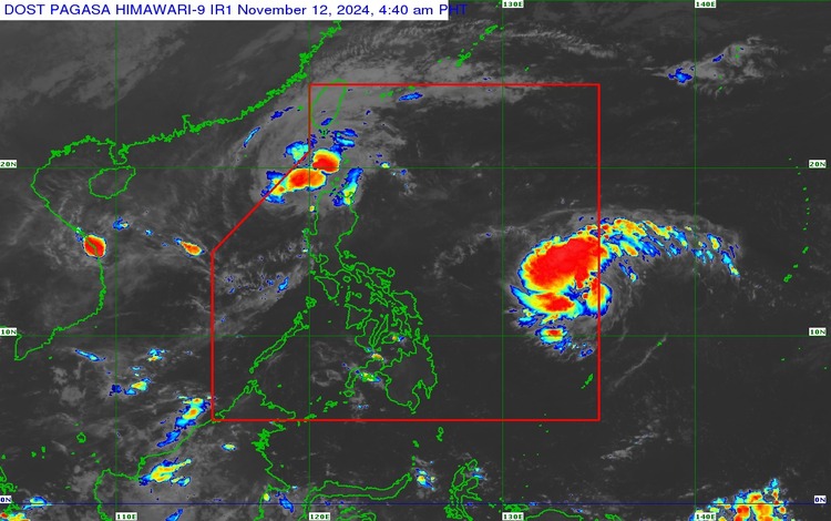
As of 4:00 AM on November 12, 2024, the Philippine Atmospheric, Geophysical, and Astronomical Services Administration (PAGASA) released its latest advisory on Severe Tropical Storm “Nika” (international name: TORAJI). The storm, now located approximately 185 km west of Laoag City, Ilocos Norte (18.3°N, 118.8°E), is gradually weakening as it moves northwestward over the West Philippine Sea. With maximum sustained winds reaching 95 km/h near the center and gustiness up to 115 km/h, “Nika” continues to pose significant threats to certain regions of Northern Luzon, especially those under Tropical Cyclone Wind Signal (TCWS) No. 1.

Current Location and Movement
Severe Tropical Storm Nika is presently moving northwestward at a speed of 30 km/h. With a central pressure of 990 hPa, this storm has a wide-reaching wind field, with strong storm-force winds extending outward up to 320 km from the center. This means that several areas in Northern Luzon are likely to experience winds, rain, and sea turbulence associated with “Nika.”
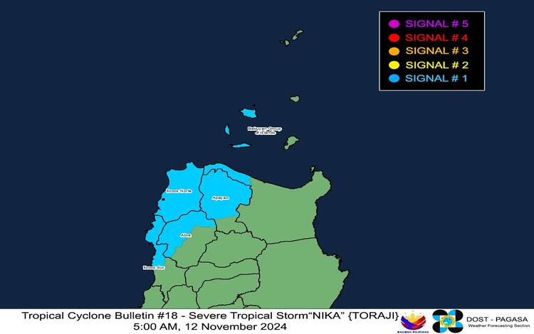
Areas Under Tropical Cyclone Wind Signal No. 1
TCWS No. 1 is raised over portions of Northern Luzon, which can expect sustained winds between 39 to 61 km/h within the next 36 hours. The areas affected include:
- Ilocos Region: Ilocos Norte and northern parts of Ilocos Sur
- Cordillera Administrative Region (CAR): The northern and western portions of Abra and the northern part of Apayao
- Cagayan Valley: Northwestern Cagayan and parts of the Babuyan Islands
While these regions are only under Signal No. 1, residents should be prepared for minimal to minor threats to life and property. However, caution is advised, especially in areas prone to landslides and flash floods due to potential heavy rainfall and localized severe winds.
Heavy Rainfall and Severe Wind Outlook
In addition to the wind warnings, PAGASA issued Weather Advisory No. 18 for heavy rainfall associated with both Tropical Cyclone “Nika” and the newly named Tropical Storm “Ofel” (international name: USAGI). This heavy rainfall outlook highlights the potential for localized flooding in low-lying areas, particularly in Northern Luzon.
As for severe winds, residents are advised that the wind flow may be stronger in coastal and mountainous regions exposed to the storm’s prevailing winds. Minimal to minor impacts from strong winds are expected within areas under TCWS No. 1. Additionally, the northeasterly wind flow is predicted to bring strong to gale-force gusts over Ilocos Sur, La Union, Pangasinan, Batanes, Cagayan, Babuyan Islands, and Isabela throughout today, especially in coastal and upland areas exposed to the winds.

Coastal Inundation and Sea Conditions
Due to the strong winds and storm surge risk, PAGASA has issued a minimal to moderate risk of coastal inundation in low-lying coastal areas of Ilocos Norte and Ilocos Sur within the next 48 hours. A Storm Surge Warning (No. 10) has also been issued for these regions, urging residents and local authorities to take necessary precautions against flooding and tidal surges.
A Gale Warning has been raised over the northern and western seaboards of Northern Luzon due to rough to very rough seas reaching up to 4.5 meters along the coasts of Ilocos Norte and northern Ilocos Sur. Smaller vessels and motorbancas are strongly advised to remain in port, while those already underway should seek shelter or safe harbor as soon as possible. Mariners in the Batanes and Cagayan areas, including the Babuyan Islands, are also warned of rough seas, with waves reaching up to 3.5 meters. Moderate seas of up to 2.5 meters are expected in northern Aurora and northern Zambales, urging caution for mariners with smaller vessels.
Track and Intensity Outlook
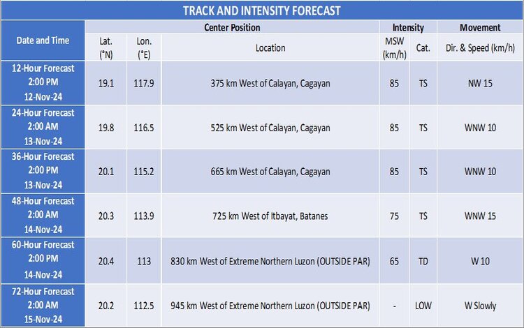
According to PAGASA, Severe Tropical Storm Nika is forecasted to continue its northwestward movement over the West Philippine Sea. It is expected to exit the Philippine Area of Responsibility (PAR) within the next 12 hours. As it moves further away from the Philippines, “Nika” is likely to weaken, possibly becoming a remnant low-pressure area as it approaches southern China.
The Arrival of Tropical Storm “Ofel” (USAGI)
While “Nika” exits the PAR, PAGASA has also issued an initial bulletin for Tropical Storm “Ofel” (USAGI), which has entered the PAR at approximately 1,170 km east of Southeastern Luzon. With maximum sustained winds of 75 km/h near its center and gustiness up to 90 km/h, “Ofel” is moving west-northwestward at 25 km/h and is expected to intensify in the coming days, potentially reaching typhoon strength.
No wind signals are currently raised for “Ofel,” though PAGASA forewarns that TCWS No. 1 may be hoisted over portions of Cagayan Valley by late this evening or early tomorrow. On Thursday, the potential landfall of “Ofel” over Northern or Central Luzon could bring intense rains, strong winds, and storm surge risks.

Preparations and Public Advisory
With both “Nika” and “Ofel” impacting weather conditions, PAGASA urges the public, especially those in vulnerable areas, to take all necessary precautions to protect lives and property. The disaster risk reduction and management offices are advised to closely monitor local weather updates and advisories. Residents in susceptible areas should prepare for potential evacuations if necessary, follow guidance from local officials, and monitor PAGASA’s updates for heavy rainfall warnings and severe weather advisories.
The next bulletin on the severe tropical storm “Nika” will be issued at 11:00 AM, while further updates on Tropical Storm “Ofel” will be provided as it continues to approach the Philippine landmass.
